SureFire

Archive for the ‘Sensors’ Category

Army Accepts Prototypes of the Most Advanced Version of IVAS

Friday, August 4th, 2023

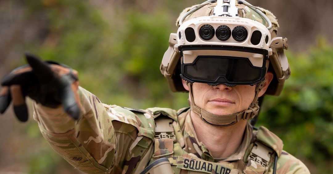
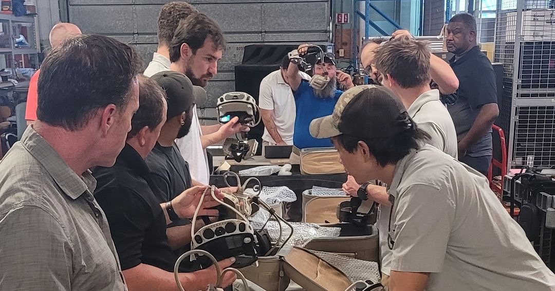
This week, the Army accepted delivery of the first 20 prototypes of the Integrated Visual Augmentation System (IVAS) 1.2 variant. The milestone is the latest step in the process of getting the most advanced version of the situational awareness system in the hands of Soldiers.

Microsoft delivered the 20 prototypes to Project Manager Soldier Warrior (PM SWAR), the program office within Program Executive Office (PEO) Soldier responsible for overseeing the development of IVAS.

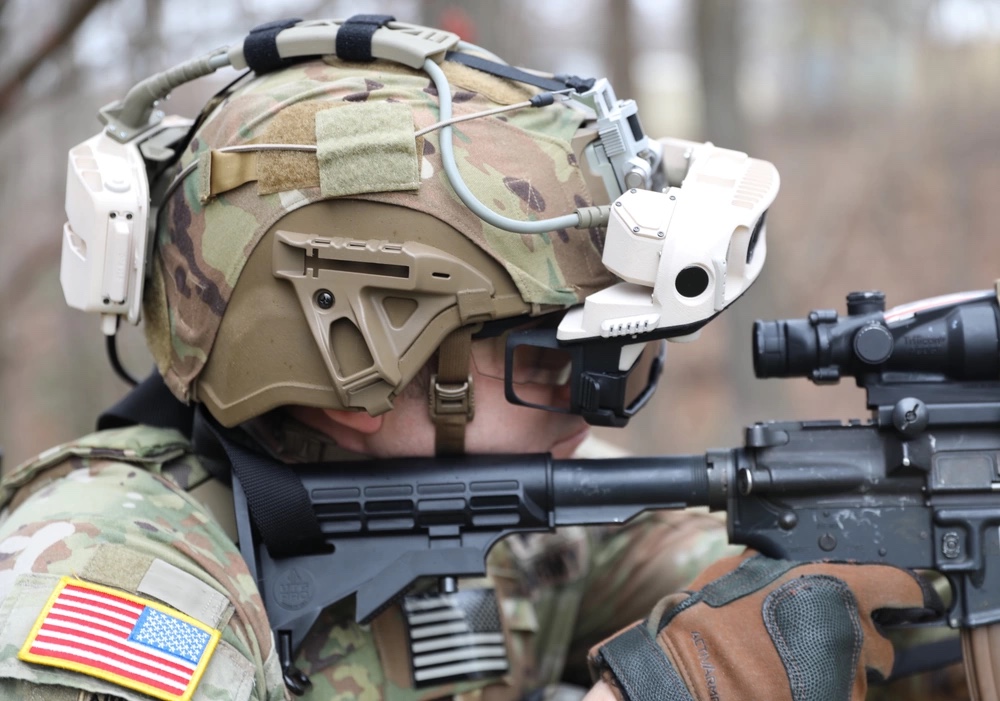
IVAS is a single platform that features an all-weather fighting goggle and a mixed reality heads-up display that integrates next-generation situational awareness tools and high-resolution simulations to provide Soldiers with improved mobility and lethality, during the day or at night. IVAS provides Soldiers with a single device to fight, rehearse and train.

“This is a really big deal for the program,” said Col. Anthony Gibbs, PM SWAR. “A little over a year ago we did an operational test with version 1.0 of the system. We learned a lot. We got a lot of good Soldier feedback. So last summer we came back and restructured the program. We took those lessons learned and all that Soldier feedback and in less than a year have what we now call version 1.2 of the system.”

Soldiers and squads will use IVAS to gain a fuller understanding of their operational environment. Its enhanced low-light and thermal sensors improve target identification. IVAS integrates with ground and air platform sensors, allowing Soldiers to see outside vehicles before dismounting into a hazardous situation. IVAS provides 3D mapping and navigation capabilities and can ingest data from Unmanned Aerial Vehicles.

“[IVAS] complements what’s currently in the Army’s inventory while expanding close combat force capabilities by leveraging the digital architecture for shared awareness and computing at the edge,” said Lt. Col. Denny Dresch, Product Manager IVAS. “IVAS provides a first-person augmented reality perspective that enables the integrating of operational data such as routes and control measures into the person’s field of view.”

The system’s embedded training tool, the Squad Immersive Virtual Trainer (SiVT), also provides Soldiers objective-based scenarios and battle drills through holographic and mixed-reality imagery, giving units the flexibility to train their squads with minimal resources.

IVAS 1.2 builds and improves on the capabilities of previous versions of IVAS (IVAS 1.0 and IVAS 1.1). Specifically, IVAS 1.2 incorporates reliability upgrades, features an improved low-light sensor and introduces a new form factor with a lower profile heads-up display (HUD) with a distributed counterweight for improved user interface and comfort.

IVAS 1.2 also has the capability to attach to a combat helmet with a “hinged” device to allow Soldiers to raise and lower the display, similar to traditional night vision goggles.

IVAS 1.0 and IVAS 1.1 will primarily be issued to schoolhouses and operational units for use in training to support the Army’s Campaign of Learning. The close combat force will receive IVAS 1.2.

“Anybody who has had IVAS on, even the early versions, knows that this is a transformative capability and really has the potential to change the way that we fight,” said Gibbs. “This new version, 1.2, we think it’s really going to hit the mark in terms of what we need to put out there for our Soldiers to give them the situational awareness and the leap-ahead capability they need to stay ahead of our peers.”

The 20 prototypes will be featured at a User Assessment in August, during which two squads of Soldiers will use IVAS 1.2 to measure the system’s performance and ensure engineering efforts are on schedule and meeting design objectives.

Story by Frederick Shear, PEO Soldier

GeoCue Expands European Footprint with New French Distributor, Escadrone

Monday, July 10th, 2023

The new partnership will bring cutting-edge geospatial hardware and software to France.
For Release July 10, 2023

Huntsville, AL – GeoCue, a leading provider of advanced geospatial software and hardware solutions, is pleased to announce the addition of Escadrone to its global network of distributors. This strategic partnership continues to extend GeoCue’s expansion into the European market, particularly in France and French-speaking countries where Escadrone will provide advanced-level TrueView 3D Imaging Sensors and LP360 LiDAR Processing Software.

Escadrone, a renowned expert in autonomous robotics integration for professional civilian applications, has been serving its customers since 2014. As a pioneer in the design, sale, and approval of drone technology, along with providing comprehensive training, Escadrone offers personalized autonomous robotics solutions to a growing number of companies. Their wide range of training, drones, equipment, and software covers various professional uses, ensuring their customers have access to cutting-edge technology.

Herbert Nicolas, CEO of Escadrone, expressed his enthusiasm about the partnership, stating, “We appreciate working with companies that put customers at the heart of product development, and creating partnerships with their distributors to ensure the customers receive the highest level of support and professionalism. GeoCue’s commitment to excellence aligns perfectly with our values, and we are excited to bring their industry-leading solutions to our customers.”

With this collaboration, Escadrone will now offer TrueView Lidar products and LP360 software to its customers. The TrueView systems enable advanced photogrammetry and LiDAR data collection, empowering customers to enhance their surveying and mapping capabilities. By integrating these powerful tools into their workflows, Escadrone’s customers gain a technological advantage in the highly competitive field of drone mapping.

Abdel Diani, Director of Global Distribution for GeoCue, commented on the partnership, saying, “We are delighted to welcome Escadrone to our global network of distributors. Their expertise in autonomous robotics and commitment to customer satisfaction make them an ideal partner for GeoCue. Together, we can provide innovative geospatial solutions to customers in France and beyond, helping them optimize their operations and achieve remarkable results.”

GeoCue and Escadrone share a common goal of delivering exceptional products and services while adapting swiftly to market conditions. This partnership not only strengthens GeoCue’s presence in the European market but also reinforces Escadrone’s commitment to providing cutting-edge solutions and unrivaled customer support.

BlueBird Aero Systems Unveils MagiCam: Field-Proven Hi-Rez Tactical Mapping Solution – Day & Night

Wednesday, June 21st, 2023

[Hepher Industrial Park, Israel, June 21, 2023] – BlueBird Aero Systems, a leading innovator in unmanned aerial Tactical systems (UAS) technology, proudly introduces MagiCam, a groundbreaking 3D Hi-Rez Large Area Mapping capability integrated with the renowned autonomous UAV, the WanderB-VTOL. This cutting-edge system revolutionizes large-scale mapping operations with its advanced Imaging payload, Smart features, stealthy operation and top-of-the-line actionable products.

MagiCam offers impressive specifications and delivers unmatched performance: It provides a projected footprint of up to 40 km2/hour (2D) and up to 12 km2/hour (3D) when flying undetected at 500 meters altitude, ensuring exceptional speed and efficiency. With a 3.2cm/pixel Ground Sample Distance (GSD), the system guarantees clear and detailed imagery, while its scalable processing time delivers quick results within hours of landing. Equipped with a uniquely designed gimbaled camera, MagiCam scans the area and captures multiple geo-tagged high-resolution images for precise mapping and 3D data. It also excels in detecting and marking changes between sorties, enabling users to track alterations over time, enhancing situational awareness and decision-making.

The mapping mission is planed using intuitive interface and executed autonomously by the UAV, ensuring seamless operation.

In defense applications, MagiCam provides valuable 3D and tactical information for combat units and facilitates target positioning for smart munitions. It enables near real-time terrain and hostile situational awareness, aiding informed decision-making. The system also contributes to battle damage assessment (BDA), operational mission planning, high- accuracy measurement tools, and mission preparation 3D databases. Optional inclusion of IR thermal mapping adds versatility for night operations.

The MagiCam payload* features impressive specifications, including a 103 MP sensor, a 5-look projected image footprint, nadir imaging capabilities, an onboard processing computer, and high-speed storage in an amazing weight of 1500 grams. It supports geo- tagging and includes a calibrated lens for precise data processing.

BlueBird presents a comprehensive tactical mapping solution with MagiCam, combining high-resolution 2D and 3D mapping capabilities with autonomous, simple and undetected operation. The system excels in providing extensive coverage per flight hour, ensuring efficient mapping operations. Equipped with powerful intelligence analysis tools**, MagiCam enables advanced data analysis and interpretation, further enhancing its value.

*Payload developed by WaldoAir from Panama City Florida. WaldoAir is the main supplier of 3D mapping payload for FEMA and the Civil Air Patrol.

**Processing of images, creation of 3D database and the smart tools supported by Skyline Software Inc. software and are used by the US army geospatial centers and many other organizations around the world.

“We are thrilled to introduce MagiCam, a game-changing tactical 3D mapping solution,” says Ronen Nadir, CEO & Founder at BlueBird. “This innovative system redefines the boundaries of large area mapping, delivering exceptional 3D products, accuracy, efficiency and capabilities never seen before. MagiCam’s integration with our WanderB-VTOL UAV further enhances its capabilities, providing customers with an unparalleled solution for their mapping needs.”

www.bluebird-uav.com

Introducing SpyX: BlueBird Aero Systems’ Revolutionary Loitering Munition

Tuesday, June 20th, 2023

Hepher Industrial Park, Israel June 19, 2023 – BlueBird Aero Systems, an Israel Aerospace Industries (IAI) Group Company, unveils its SpyX, a cutting-edge Loitering Munition UAV platform designed to empower military forces with unmatched tactical capabilities such as 50Km operational range, 1.5 hours mission time, autonomous electro-optical guided attack, optimal effect-on-target and tight integration with Bluebird’s VTOL ISR UAV family. This groundbreaking technology represents a significant milestone in the evolution of unmanned aerial vehicle (UAV) systems and brings a new era of precision and efficiency to the battlefield, and in an extremely affordable price.

SpyX, developed by BlueBird Aero Systems, is an expendable electric mini-UAV, designed for loitering & strike missions, to enable tactical teams to organically detect, confirm and hit targets at ranges up to 50Km. To increase its target detection capabilities, the SpyX is integrated with a revolutionary belly-mounted dual-sensor stabilized payload and advanced video tracker, to enable autonomous and accurate electro-optical guided attack on the target. To increase its effectiveness, the 2.5Kg warhead (like combined Anti-Personnel, Anti-vehicles, or Anti-tank warheads) is loaded to the SpyX Loitering Munition just before launch, as per the required effect-on-target.

“SpyX is a game-changer in the field of military UAV platforms,” says Ronen Nadir, CEO of BlueBird Aero Systems. “We are proud to introduce this advanced system that combines innovative technology with unmatched versatility and cost-effectiveness. SpyX not only enhances situational awareness and enables precision and effective strikes, but also revolutionizes tactical battlefield superiority through its tight integration with our VTOL ISR UASs. It is a testament to our commitment to provide our customers with cutting-edge solutions that meet their evolving needs of tactical military operations”.

Key Features and Benefits of SpyX:

• Operational Range: An impressive operational range of up to 50km.

• Endurance: An impressive endurance of 1.5 hours, ensuring persistent surveillance and the ability to strike when targets are discovered and identified.

• Versatile Warhead Options: Multiple types of warheads, including anti-tank and anti-personnel/lite vehicle, ensuring optimal effectiveness against different target types.

• Agility: With a weight of only 10 kg, SpyX is a compact and agile platform, enabling rapid deployment and maneuverability in dynamic scenarios.

• High Attack Speed: With an attack-speed of 250 km/h, SpyX ensures efficient engagement of targets. The Target will not see nor hear it coming…

• Separate Warhead Storage: SpyX unique design allows the warhead to be stored separately, to enhance logistic storage capabilities, reduce the required space for safe bunker storage, and simplifies the transportation and handling of the system.

Advanced Military Operations:

SpyX revolutionizes the way tactical military operations are conducted, providing an unparalleled advantage in various scenarios:

• Precision Strikes: With a designed Circular Error Probable (CEP) of less than 1 meter, SpyX ensures exceptional precision in targeting to minimizes the risk to ground forces and reduces collateral damage.

• Reconnaissance and Surveillance: With its advanced dual-sensor payload, the SpyX provides real-time enhanced situational-awareness, enabling better target detection capabilities and decision-making in the field. Additionally, BlueBird’s unique open architecture design allows for joint reconnaissance and target detection efforts by integrating SpyX with BlueBird’s VTOL ISR UASs such as WanderB-VTOL and ThunderB-VTOL UAS. This collaborative approach enhances the mission effectiveness by allowing target detection before launching SpyX, while covering larger areas for longer time using VTOL UAVs, maximizing operational efficiency.

• Force Protection: Safeguard military personnel and critical infrastructure by identifying and neutralizing threats efficiently and effectively. SpyX’s versatile warhead options allow for adaptable mission planning, enabling precise engagement of both armored targets and personnel or light vehicles.

For more information about SpyX and BlueBird’s range of UAS solutions, please visit www.bluebird-uav.com.

GA-ASI Seaguardian Supports Northern Edge 2023

Monday, June 12th, 2023

Flights Featured ESM, COMINT, Detect and Avoid, AIS, and Link 16 Capabilities

SAN DIEGO – 07 June 2023 – As part of a U.S. Navy contract, an MQ-9B SeaGuardian® Unmanned Aircraft System from General Atomics Aeronautical Systems, Inc. (GA-ASI) supported the NORTHERN EDGE 2023 (NE23) exercise May 8-19, 2023. The training exercise, which took place in the Gulf of Alaska, was one of a series of U.S. Indo-Pacific Command (IPACOM) exercises that prepares joint forces to respond to crises in the Asia Pacific region.

GA-ASI’s SeaGuardian is a maritime derivative of the MQ-9B SkyGuardian® and remains the first UAS that offers multi-domain Intelligence, Surveillance, Reconnaissance and Targeting (ISR&T) and has an internal payload suite that can prosecute surface and subsurface targets in support of Fleet Operations.

During NE23, SeaGuardian provided real-time Maritime ISR&T data feeds to the various IPACOM operations centers including Pacific Fleet, Pacific Air Forces, Joint Base Elmendorf-Richardson Joint Exercise Control Group (JECG) and various exercise and real-world watch floors. Real-time sensor data – including Signals Intelligence (SIGINT), radar, and full-motion video – was Processed, Exploited and Disseminated (PED) by operators via Minotaur Mission System. The Minotaur system was developed by the Johns Hopkins University Applied Physics Laboratory. It links sensors, SIGINT, cameras, radar and communications equipment into a single, automated system that allows operators to more efficiently identify, track and target simultaneously with other users for expedited dynamic tasking. This classified data was transmitted to the Joint Fires Network using new DoD technologies allowing for the smart routing of communications between widely distributed communications nodes.

In addition, SeaGuardian showcased an array of operational payloads, including Electronic Support Measures (ESM), Radar Moving Target Indication (MTI) and Inverse Synthetic-Aperture Radar (ISAR), Communication Intelligence (COMINT), Automatic Identification System (AIS), high-definition Electro-Optical/Infra-Red (EO/IR) imaging system and Link 16.

The ESM payload on SeaGuardian was supplied by Sierra Nevada Corporation and the COMINT payload was made by L3Harris Technologies. The aircraft featured the SeaVue Multi-role radar from Raytheon Technologies. GA-ASI’s Link 16 solution leveraged the L3Harris Small Tactical Terminal (STT) KOR-24A radio and Ultra Electronics Air Defense Systems Integrator (ADSI) host software ran on the Parry Labs Stellar Relay Common Compute Module.

The GA-ASI-developed Detect and Avoid (DAA) system was also installed in SeaGuardian and received a limited certification from NAVAIR. This enabled SeaGuardian to perform beyond visual line-of-sight (BVLOS) operations within the exercise airspace.

SeaGuardian’s multi-domain capabilities allows it to flex from mission to mission and pass real-time sensor data directly to the fleet through Link 16 and satellite feeds to the shore-based command and intelligence centers. During NE23, the MQ-9B effectively passed ISR&T information to various surface and air units, and a litany of other U.S. and foreign units taking part in the exercise.

In addition to its contributions to the exercise, the SeaGuardian self-deployed from GA-ASI’s Desert Horizons flight operations facility in El Mirage, Calif., to Joint Base Elmendorf-Richardson, Alaska, covering over 2,000 nautical miles in a single flight and demonstrated SeaGuardian’s unrivalled expeditionary attributes. The aircraft self-deployed back to El Mirage following the exercise. All flights were flown from a forward deployed Mission Command Element comprised of a Certified Ground Control Station and Mission Intelligence Station located Naval Air Station Whidbey Island, Washington, exercising UAS Expeditionary Concept of Operations (CONOPS) in support of Exercise objectives.

Rampart Range Day 23 – Pathfinder from ARA

Tuesday, May 30th, 2023

ARA’s Pathfinder is a seismic unattended ground sensor which was fielded to the US Army as the Expendable Unattended Ground Sensor System. Over 40,000 have been deployed.

This buried sensor can detect human foot traffic at 10 m and offroad vehicle traffic at 25 m. Additionally, it integrates with TAK and can report up to 10 km from the controller. The system uses a burst transmission to send alert reports and can be integrated with other sensors to slew to the area of interest.

The battery will last for up to six months based on 50 alerts per day. A version which is twice as large will last for up to two years. While the batteries can be replaced by ARA, Pathfinder is considered expendable. Each sensor weighs 11 oz.

The E-UGS 2000 model is not subject to ITAR export controls.

This and other products shown at Rampart Range Day are available for unit and agency orders in Canada and the US through Rampart.

Elbit Systems UK to Deliver Ground-Based Surveillance Radar to British Armed Forces

Thursday, May 25th, 2023

London, 23 May 2023 – Elbit Systems UK has been awarded a contract from the UK Ministry of Defence (MOD) to provide a series of Ground-Based Surveillance Radar (GBSR) systems, manufactured and developed in the UK and Europe, to the British Armed Forces to support front line threat detection for a range of end-users.

Elbit Systems UK will deliver 90 GBSR systems throughout 2023 and 2024, with a follow-on option of an additional 40 systems. The GBSR system is easily portable and uses Digital Signal Processing to detect, track and classify targets moving on or close to the ground.

The systems being delivered have been customised by Elbit Systems UK to meet the specialist capability requirements of a joint end-user community. These adaptations include an optimised stabilisation unit and open architecture software upgrades to facilitate integration both with existing and future MOD systems.

The system also incorporates capture software that allows operator performance to be analysed. This will support extensive, data-driven training for the user.

Martin Fausset, CEO of Elbit Systems UK, said:

“Elbit Systems UK has a deep understanding of the threat environment in which our servicemen and women operate. By offering a portable solution for medium and short range target detection, Elbit Systems UK is continuing to support the UK Ministry of Defence in providing leading situational awareness for those on the front line, using some of the best technology available.”

HENSOLDT Strengthens Air Surveillance in Ukraine

Friday, May 19th, 2023

Taufkirchen/Germany, 16 May 2023 – Sensor specialist HENSOLDT is supplying six more of its TRML-4D high-performance radars to strengthen Ukraine’s air defence. As part of an order worth more than 100 million euros, the radars will be delivered in the second half of the year following training of the Ukrainian operators. HENSOLDT already has several TRML-4D radars under contract for Ukraine as part of the IRIS-T SLM air defence system.

Thomas Müller, CEO of HENSOLDT, said: “We are pleased to support Ukraine with six additional TRML-4D radars, which will further strengthen Ukraine’s air surveillance and air defence sensor network. The information from the TRML-4D feeds into Ukraine’s national air situation picture, protecting Ukrainian citizens. We are proud to be able to deliver this much-needed equipment at short notice.”

TRML-4D uses the latest Active Electronically Scanned Array (AESA) radar technology with multiple digitally shaped beams. It is capable of early detection of various types of aerial targets such as aircraft, helicopters and cruise missiles. It ensures the rapid detection and tracking of about 1,500 targets in a radius of up to 250 km.

HENSOLDT has decades of experience with radar systems for air defence and actively drives the development of key technologies in this field. The company’s portfolio also includes the Twinvis passive radar, the Spexer product family and radars for securing ship and air traffic. Among other things, HENSOLDT supplies radars for the frigates and corvettes of the German Navy, for airspace surveillance and for approach control at airfields of the German Armed Forces.