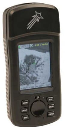
Satellite Imagery Enhanced GPS (SIMEG) Receiver is a rugged, handheld GPS receiver that correlates the receiver’s position and displays it on satellite imagery as a geo-rectified moving-map. What makes the SIMEG so unique is that it supports all National Geospatial Agency digital imagery and map products down to 1-meter CIB imagery. Upgrades are being worked for NGA’s Vector Product Format and specialty products developed by NGA and terrain teams as well as commercial products such as USGS Digital Ortho Quads for work back here in CONUS. While a few new commercial receivers show commercial imagery, no commercial GPS receiver displays NGA products. That alone would make the SIMEG worth pursuing but the team at DFT has also made the SIMEG compatible with PFPS route and threat overlay files. This means you can plan a mission on a Mission Planning terminal and export overlays to the SIMEG. They will show up on the imagery just like they do on FalconView. Top that!
The SIMEG has been under development for about four years and in use by specialized forces. I say development, because as I stated earlier, DFT is constantly updating software to support new requirements and emerging digital geospatial products. DFT is also looking at ways to improve the form and fit of the capability but I’ll leave it up to them to tell you more.
In addition to the SIMEG, DFT has a range of ISR technologies aimed at the small unit.
For more information contact Digital Force Technologies
Tags: DFT, Digital Force Technologies, GPS, NGA, SIMEG


