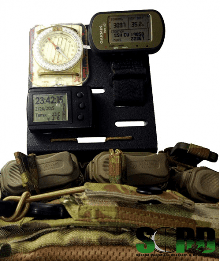
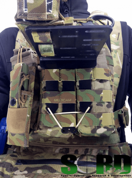
SORD’s Nav Platform is a Don/Doff aid for the attachment of navigation devices. Made from Kydex, the Nav Platform features functionally spaced holes for threading elastic cord. It comes with 600mm of elastic shock cord, along with a single toggle for the end user to cut, thread, tie, and/or weave the cord to their own requirements. MOLLE spaced slots on the platform allow for speed threading of batons. The platform is designed to be flexible enough so that it will bend rather than splinter in the event of a face-first landing.
MOLLE column-sized tangs allow the end user to weave the Nav Platform into a carrier or vest. Fefatures a quick attach / single handed release.
Available in Black.
sordaustralia.com – Nav Platform
Tags: SORD


Can anyone ID that compass?
Looks like a cut down Silva type 4/54 in Mils as opposed to degrees
Ah, that is how they got that shape….
I assume they drilled the holes as well. No problem. Mod time.
Look s like a silva – 4/6400, Great work SORD, looks good
Because nothing says accurate compass reading like setting it within a few inches of relatively strong magnetic fields….
HA!!! pretty sure the guy that did the MOD, cant afford power tools, He is still serving. All hand cut/ground and polished. (with the glow tape stuck on behind it)
Joe,
The reason the boards are configured like they are I.E. Nav items so close together is dictated by the distance between the straps on a parachute harness. All NAV boards sizing is a result of this. The key is to use one or the other. The compass is a backup incase mechanical navigation needs to be used.
I was referring to the proximity of batteries, ammo, and mag components to the compass affecting its accuracy.
If several degrees of error are acceptable for your particular movement (vertical or horizontal), then more power to you.
Considering that you are navigating off of GPS when under canopy, not really going to be a a concern. Haven’t seen a compass tell me my glide ratio.
-37.7281071°, 144.9467638°
Sord Australia HQ?
Yep, 25-27 Hocking Street Coburg North, Victoria, 3058 is where http://dominoc925-pages.appspot.com/mapplets/cs_mgrs.html plots 55hcu1985822367 in google maps.
As a vet scout I can see how this would be appealing. However, as soon as you come into contact this piece of kit (and your nav gear) is gonna get smashed and or become a snag hazard. Is it quick detaching?
Yep, Takes less than 5 seconds to remove one handed (even for lefties) and chuck it in a dump pouch. Also, Lanyard Technology is ALWAYS a good idea with MEI’s
I am sure this like the S&S nav boards are primarily intended for free fall operations. Allowing you to still fly your canopy with both hands while making use of the compass GPS and Alti right in front of your face.
Nicely done then.