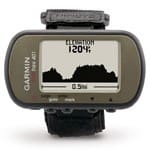
 The Foretrex 401 is a lightweight (3.1 oz with batteries!), wrist mounted GPS receiver that has become very popular with troops down range. The 401 can often be seen strapped to a weapon’s stock so that the shooter can conduct a GPS check by simply rolling his carbine toward his face. In addition to GPS, the device also integrates an electronic compass (yes, mounting it to a rifle affects it) as well as a barometric sensor which comes in quite handy while operating in mountainous terrain. The Foretrex 401 also runs the free Jumpmaster Software package designed to assist parachutists to compute release points. Data for this as well as other applications is easily updated via a USB cable. As an added bonus, you can share waypoint and track data wirelessly with other 401s. It is powered by readily available by 2 AAA batteries which provide up to 17 hours of use.
The best place we have found to purchase Garmin products is Strohman Enterprises. In fact, they have a special on the Foretrex 401 for $159. Owned by Lt Col USMC (Ret) Joseph Strohman, the company supplies Garmin and Aimpoint products to LE & Military organizations as well as individual personnel. Joe and his crew are well versed in all of the products and can answer customer’s questions about anything from mounting solutions to loading map data for the AOR.


