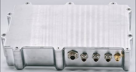
I get excited when I find out about small businesses with innovative technologies that solve real problems, particularly those owned by fellow veterans. Even better when these capabilities are low cost.
Take for example, MSRS Navigation, which was founded by a retired Tier One operator after having experienced GPS jamming while deployed overseas. In fact, all five of the company’s employees are Veterans and the gear is made in Asheville, NC.
Confronting the Electronic Warfare threat is now a challenge faced by everyone and the Western use of Global Positioning System for navigation can no longer be solely relied upon to accurately determine position and route.

MSRS Navigation has developed the only ITAR-free, Denied-GPS navigation system. What’s more, the system is completely non-RF, with no reliance on satellites or any signals for that matter. There’s nothing to jam.
Having been awarded two patents with three more in process, they instead rely upon an AI/ML engine which examines data and identifies errors from GPS degradation, identifying last known good point to base modeling from. This is supplemented with real-time data from multiple sensors. The result is .1 meter accuracy per mile and is correctable by the end user at any point by simple correction via drag/drop of the icon on the map-based interface GUI, to the correct point. Alternatively, there is a plug-in for ATAK users.
The systems runs independently from, but in parallel with GPS, allowing the user to rely upon GPS in high-fidelity environments. At any point, the user can switch to MSRS if for example, they enter a degraded environment such as jamming or dense foliage or tunnels. MSRS always runs in the background.
The current Army program of record is Mounted Assured Positioning, Navigation and Timing System (MAPS) Gen II which is great if you’re part of the BOIP. If not, MSRS is available today, for immediate deployment. Over forty of their fly away kits (FAK) are currently in use with US and International SOF in overseas combat environments.
Simple to employ, the FAK comes packed in a Pelican 1200 and can be installed in under 30 minutes. Additionally, MSRS is about the quarter of the price of MAPS.
While the system is currently configured for ground and sub-T navigation, the company has a CRADA in place with USSOCOM through SOFWERX to support an upcoming evaluation of the system. To expand its use, they have partnered with Hefring Marine out of Iceland to build a Maritime system and expect to have a working prototype in early 2025.
For more information, visit www.msrsnav.com.
–Eric Graves


The portrait photos on the “Team” page are almost certainly AI generated… immediate red flag.
Based on what evidence?
These guys are real.
It says GUI you and “my atak interface” in line two, sounds like a bunked system we all might as well just walk, that’s what james said
You’re coming in broken and stupid.