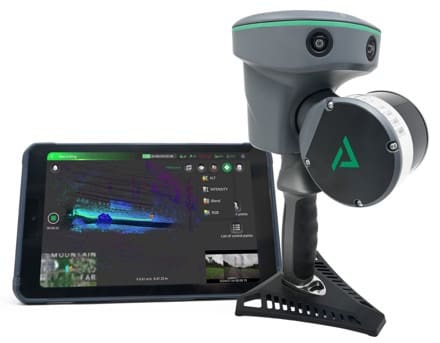
Huntsville, AL – GeoCue, a leader in geospatial technology, is proud to announce the release of LP360 Land, a new addition to the LP360 software ecosystem designed to elevate handheld LiDAR scanning with the TrueView GO.
The TrueView GO, launched in August, set a new standard for handheld LiDAR scanners by combining advanced hardware with user-friendly operation. Now, LP360 Land empowers users to transform their raw handheld data into valuable insights and deliverables with ease.
“The integration of LP360 Land with the TrueView GO is a game-changer for professionals seeking efficient and accurate data processing,” said Frank Darmayan, CEO of GeoCue. “This powerful combination enables users to seamlessly process, visualize, and analyze their handheld LiDAR data, enhancing their overall workflow.”
LP360 Land offers an intuitive workflow that simplifies the processing of LiDAR, GNSS, and SLAM handheld sensor data. Key features include:
• Multi-scan import and processing capability
• Coordinate systems (datum and projection) management
• Powerful SLAM/PPK/RTK point cloud processing: Generate accurate and colorized point clouds even in GPS-denied environments
• Advanced visualization tools: Utilize multiple synchronized windows, including 2D, 3D, profile, and immersive views.
• QA / QC and data editing / cleaning tools
• Manual and automatic registration (LAS to LAS and LAS to Control Points)
• Image explorer for contextual analysis (Point cloud to Photo)
“We are excited to see how LP360 Land will enhance the capabilities of TrueView GO users,” said Vivien Heriard-Dubreuil, CEO of mdGroup. “With LP360 Land, the user can combine LiDAR data coming from mobile, aerial and ground sensors to complete a job and work on a registered, colorized and georeferenced point cloud. This software reflects our commitment to providing innovative solutions that meet the evolving needs of the geospatial community.”
LP360 Land is available in two plans to suit different user requirements:
• Basic: Ideal for TrueView GO users needing essential LAS file processing and fundamental data management tools.
• Standard: Includes all Basic features plus advanced functionalities like multi-cycle processing, control point management, point cloud registration, and automatic target recognition.
To further maximize your workflow, LP360 Land seamlessly integrates with LP360 Cloud, a suite of cloud-based tools designed to simplify the management, archiving, sharing, and collaboration of geospatial projects.
Explore the Full LP360 Product Line
LP360 Drone: Comprehensive tools for drone-based geospatial data workflows, including visualization, quality assessment, classification, 3D editing, and analysis.
LP360 Land: Tailored for TrueView GO and compatible handheld scanners, offering robust SLAM/PPK/RTK and imagery processing and advanced visualization capabilities.
LP360 Geospatial: Optimized workflow for processing LiDAR data or images, QA/QC data from various aerial or mobile sensors.
LP360 Cloud: Cloud-based solutions for project management and collaboration.
For more information about LP360 and how it can enhance your LiDAR and photogrammetry please visit www.lp360.com.com.
To learn more about GeoCue, visit www.geocue.com.

