We’re big fans of the multi-function augmented reality nav app Theodolite. The developer, Hunter Research and Technology has announced that they’ve added a new World Geodetic Datum Pack option. This brings over 220 new datums to the app, covering countries and regions on all continents around the world. The new feature is targeted at professional, military, search and rescue, and outdoors users who need more accuracy from the GPS hardware on their iOS devices, or who want to work with specialized coordinate systems and grids.
Here is the full press release –
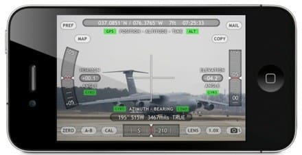
Williamsburg, Virginia – Hunter Research and Technology is pleased to announce that the popular multi-function augmented reality nav app Theodolite has added a new World Geodetic Datum Pack option. Theodolite works as a compass, GPS, map, zoom camera, rangefinder, tracker, and two-axis inclinometer. The app set a new standard for augmented reality navigation apps when it debuted in 2009, and has been the #1 selling navigation app in iTunes stores around the world. Theodolite overlays real-time information about position, altitude, bearing, range, and horizontal/ vertical inclination on the live camera image of an iPhone, iPad, or iPod touch, turning the device into a sophisticated electronic viewfinder. Uses are endless, and Theodolite is great for outdoor sports, hiking, boating, hunting, golf, sightseeing, photography, and navigation. The app is used in the field every day by surveyors, geologists, architects, engineers, military personnel, competitive sportsmen, and search and rescue workers.
Theodolite lets users take geo-tagged and geo-stamped camera images, screenshots, movies, and screen movies directly from the app. Users can choose to watermark geographical data and custom notes directly on photos and movies for later reference. The app also includes features for serious users like a navigation calculator, map with live markers, data logging, e-mail export with KML data, system-wide clipboard integration, percent grade display, mil compass readout, optical rangefinders (including a mil-based reticle and sniper-style stadiametric graphs),
colored lens filters to improve use in dark conditions and preserve night vision, and team tracking. Theodolite supports military grid reference system (MGRS) coordinates, universal transverse Mercator (UTM) coordinates, British/Irish National grid, and six latitude/longitude formats.
The new World Geodetic Datum Pack, available as an optional in-app purchase, adds over 220 new geodetic datums to the app for more accurate position and altitude computation from GPS data. Datums include NAD-27, NAD-83, OSGB-36, ED-50, and hundreds of others, covering regions and countries on all continents around the world. The new feature is targeted at professional, military, search and rescue, and outdoors users who need more accuracy from the GPS hardware on their iOS devices, or who want to work with specialized coordinate systems and grids in regions of operation all around the world.
Device requirements:
* iPhone or iPod touch (Theodolite)
* Camera-equipped iPad or iPad Mini (Theodolite HD)
* iOS 4.3 or later
Pricing and Availability:
Theodolite and Theodolite HD are available on the iTunes App Store in the Navigation category for a winter sale price of $3.99 USD. The World Geodetic Datum Pack is available as an optional in-app purchase for $2.99 USD. More information, including screenshots, is available on the Hunter Research and Technology website. Media professionals interested in reviewing Theodolite can request a promotional code to download the apps from iTunes at no cost.
Theodolite 3.2 (iPhone and iPod Touch)
Theodolite HD 3.2 (iPad and iPad Mini)
Purchase and Download Theodolite (iPhone and iPod Touch)
Purchase and Download Theodolite HD (iPad and iPad Mini)