SureFire

Archive for the ‘Tac Apps’ Category

Introducing Nav Camera: Photos And Movies With Geolocation Data Overlays

Tuesday, August 26th, 2014

Williamsburg, Virginia – Hunter Research and Technology, developer of the popular Theodolite app series, is excited to announce its newest iPhone app, Nav Camera.

marsh1

Nav Camera uses the proven navigation, augmented reality, and image processing engines from Theodolite to create an app that focuses on photography and video recording with data overlays. The app has been crafted with attention to detail, and benefits from over five years of development and testing heritage, along with real world usage by surveyors, geologists, architects, engineers, competitive sportsmen, first responders, military personnel, and search and rescue workers around the world.

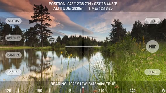
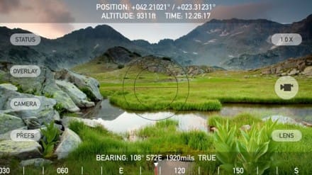
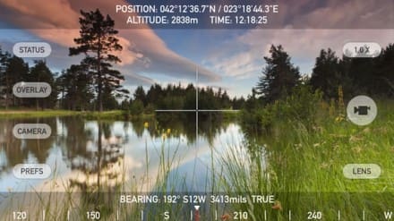
Nav Camera lets users take photographs and record movies in landscape and portrait orientations with geolocation overlays and custom notes. Geolocation overlays include date, time, position, altitude, GPS datum, and compass bearing. Overlay data is updated in every frame when recording movies, which is great for documenting dynamic scenes or scanning an area. Users can enter up to four lines of custom notes to be rendered into the overlay, which is perfect for job descriptions, project names, company/staff information, invoice numbers, or additional comments/documentation. Various parts of the overlay can be turned on or off, and multiple overlay colors are available.

gnp

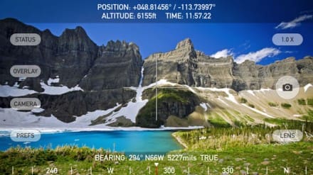
Nav Camera includes features for serious users including multiple reticles (three types of crosshairs and an SLR-style focus/exposure indicator), colored lens filters to improve use in dark conditions and preserve night vision, and multiple position formats including military grid reference system (MGRS), universal transverse Mercator (UTM), British/Irish National Grids, and six latitude/longitude variations. The optional “Datum Pack” adds over 220 geodetic datums to the app for more accurate position and altitude computation from GPS data. Optional datums include NAD-27, NAD-83, OSGB-36, ED-50, and hundreds of others, covering regions and countries on all continents around the world.

Find out why apps like Nav Camera and Theodolite, and their field-proven results, are featured in Apple Keynotes, written up in magazine articles and professional journals, and used by everyday explorers and pro users around the world. Where will you take Nav Camera on your next adventure?

lake

Nav Camera works on any iPhone or iPod Touch with a camera, running iOS 7 or later.

Nav Camera Website
hrtapps.com/navcamera

Nav Camera on the iTunes App Store
itunes.apple.com/us/app/nav-camera-take-photos-record

Applied Ballistics Announces iOS Version Of Mobile App Highly-Demanded Ballistics Software Now Available For Apple Devices

Wednesday, July 16th, 2014

Cedar Springs, MI – July 11, 2014 – Applied Ballistics is excited to announce the official release of the highly-anticipated iOS version of their mobile app, “Applied Ballistics Mobile”; allowing Apple iPhone and tablet owners to download and take advantage of the ballistic computing software that has become popular on the Android platform.

screen568x568

The Applied Ballistics Mobile App runs a Point Mass ballistic solver; the state of the art ballistic solver calculates long-range rifle trajectories, and along with the library of ballistic coefficients provided by Bryan Litz, makes this the most accurate and complete ballistics app available.

The program integrates the equations of ballistic motion numerically, using a 4th-order Runge-Kutta method ; the standard way of solving dynamic equations of motion in aircraft and missile simulations. Former missile design engineer, ballistician and President of Applied Ballistics, LLC, Bryan Litz wrote this solver, which is common among many of the Applied Ballistics devices – providing the same accuracy you expect.

screen568x568 (1)

The application also comes with G1 and G7 BC’s for over 1,300 bullets- allowing users to easily select their bullet and have its data loaded into each individual ammo profile automatically.

“Applied Ballistics is thrilled to announce the release of this highly-sought iOS version of the Applied Ballistics mobile app,” stated Litz. “We have worked extensively on this product with intense development to ensure we continue to offer our loyal customers with a solution to their ballistics computing. With the success of the Android version of the application – which was launched 2 years ago, the demand for the iOS version has been high, and we are excited to now offer a version that is compatible with iPhone as well.”

The new mobile app accounts for all major and minor trajectory variables that a shooter could encounter. The app displays single shot solutions in HUD view or Reticle view, as well as multi-shot solutions in Reticle view, table and graph.

Shooters can enter their observed drop-at range and the program will calibrate; incorporating muzzle velocity and drop-scaling over various segments of the trajectory to ‘true’ the predictions based on actual bullet impact.

A web-sync feature allows you to store your rifle and ammunition libraries online for quick retrieval, as users are able to backup all the profiles online or restore them to a device.

Available now through iTunes https://itunes.apple.com/us/app/applied-ballistics/id785619104?ls=1&mt=8, the Applied Ballistics Mobile App costs $29.99, and requires iOS 7.0 or later for proper functionality. Compatible with iPhone, iPad, and iPod touch devices, this app is optimized for iPhone 5.

appliedballisticsllc.com

TacApps – MIL Sistemika – Personal Eye System (PES)

Sunday, March 30th, 2014

MIL Sistemika is a Slovenian firm that develops and sells commercial off-the-shelf products in the area of military command & control, communications and training, and simulation products.

PES Pamplet

Their Personal Eye System is a personal tracking, asset tracking, military navigation, and tactical data sharing application designed for Military personnel, Law Enforcement, security forces, Emergency Services, VIP protection services, and asset tracking, designed for use with Android-powered devices.

It offers topographic land and sea navigation, asset tracking, and blue force tracking – BFT and Common Operational Picture (COP) sharing. PES is currently being evaluated by the Slovenian armed forces, Police and National Crisis Management Center as a part of their BMS (Battlefield Management System).

Click to view .pdf
PES PDF

PES is currently available on Google Play – play.google.com/store/apps/details?id=si.milsistemika.pes

pes.milsistemika.com

Tactical NAV For iPhone Update

Friday, December 13th, 2013

download

AppDaddy’s Tactical Nav for iPhone just received an update to mirror the recent Tactical NAV HD release. The Tactical NAV app now supports the following features:

* Military quality GPS tactical navigation system
* WGS 84 standard
* Tested in combat to ensure utmost accuracy and reliability
* 1:50,000 map scale overlay (1km by 1km gridsquares)
* Waypoint plotting functionality
* Fully editable waypoints
* Location and waypoint sharing via email with other users
* Compass lock function
* Fast user switching between degrees, Mils, elevation, LAT/LONG, and MGRS data
* Camera mode with heads-up data displayed in real-time with photo stamping ability
* One-button night mode function
* “Go to Grid” option
* Multi-tasking support

itunes.apple.com/us/app/tactical-nav/id412650650?mt=8

Tactical NAV HD For iPad

Tuesday, November 26th, 2013

screen480x480

AppDaddy Technologies’ Tactical NAV HD is a military-quality GPS tactical navigation system, built from the ground up for the iPad. It features a 1:50,000 map scale overlay, with live map annotations, drawing and distance calculation, and fully editable waypoint plotting functionality. The app utilizes MGRS, BNG, UTM, LAT/LONG, and USNG coordinates. It also features a one-button night mode function which allows for easier viewing in the dark.

itunes.apple.com/us/app/tactical-nav-hd/id759349889?ls=1&mt=8

TacApps – TACNAV Now Available For Android

Wednesday, September 18th, 2013

Jonathon Springer, creator of the popular Tactical NAV app informed me that it is now available for Android. Look for it on Google Play.

20130917-215053.jpg

Features
-Military quality GPS tactical navigation system
-WGS 84 standard
-1:50,000 map scale overlay (1km by 1km gridsquares)
-Waypoint plotting functionality
-Fully editable waypoints
-Location and waypoint sharing via email with other users
-Compass lock function with fast user switching between degrees, Mils, elevation, latitude/ longitude, and MGRS coordinate data
-Camera mode with heads-up data displayed in real-time with photo stamping ability
-One-button night mode function
-“Go to Grid” option

20130917-221059.jpg

www.tacticalnav.com or www.facebook.com/TacticalNAV

TacApps – Cop Slang App

Thursday, August 29th, 2013

Cop Slang

Thought some of our LE readers might be interested.

www.copslang.com/

TacApps – Theodolite Nav App Adds Geo Datum Pack

Wednesday, February 20th, 2013

We’re big fans of the multi-function augmented reality nav app Theodolite. The developer, Hunter Research and Technology has announced that they’ve added a new World Geodetic Datum Pack option. This brings over 220 new datums to the app, covering countries and regions on all continents around the world. The new feature is targeted at professional, military, search and rescue, and outdoors users who need more accuracy from the GPS hardware on their iOS devices, or who want to work with specialized coordinate systems and grids.

20130220-093321.jpg

Here is the full press release –

Williamsburg, Virginia – Hunter Research and Technology is pleased to announce that the popular multi-function augmented reality nav app Theodolite has added a new World Geodetic Datum Pack option. Theodolite works as a compass, GPS, map, zoom camera, rangefinder, tracker, and two-axis inclinometer. The app set a new standard for augmented reality navigation apps when it debuted in 2009, and has been the #1 selling navigation app in iTunes stores around the world. Theodolite overlays real-time information about position, altitude, bearing, range, and horizontal/ vertical inclination on the live camera image of an iPhone, iPad, or iPod touch, turning the device into a sophisticated electronic viewfinder. Uses are endless, and Theodolite is great for outdoor sports, hiking, boating, hunting, golf, sightseeing, photography, and navigation. The app is used in the field every day by surveyors, geologists, architects, engineers, military personnel, competitive sportsmen, and search and rescue workers.

Theodolite lets users take geo-tagged and geo-stamped camera images, screenshots, movies, and screen movies directly from the app. Users can choose to watermark geographical data and custom notes directly on photos and movies for later reference. The app also includes features for serious users like a navigation calculator, map with live markers, data logging, e-mail export with KML data, system-wide clipboard integration, percent grade display, mil compass readout, optical rangefinders (including a mil-based reticle and sniper-style stadiametric graphs),
colored lens filters to improve use in dark conditions and preserve night vision, and team tracking. Theodolite supports military grid reference system (MGRS) coordinates, universal transverse Mercator (UTM) coordinates, British/Irish National grid, and six latitude/longitude formats.

The new World Geodetic Datum Pack, available as an optional in-app purchase, adds over 220 new geodetic datums to the app for more accurate position and altitude computation from GPS data. Datums include NAD-27, NAD-83, OSGB-36, ED-50, and hundreds of others, covering regions and countries on all continents around the world. The new feature is targeted at professional, military, search and rescue, and outdoors users who need more accuracy from the GPS hardware on their iOS devices, or who want to work with specialized coordinate systems and grids in regions of operation all around the world.

Device requirements:
* iPhone or iPod touch (Theodolite)
* Camera-equipped iPad or iPad Mini (Theodolite HD)
* iOS 4.3 or later

Pricing and Availability:
Theodolite and Theodolite HD are available on the iTunes App Store in the Navigation category for a winter sale price of $3.99 USD. The World Geodetic Datum Pack is available as an optional in-app purchase for $2.99 USD. More information, including screenshots, is available on the Hunter Research and Technology website. Media professionals interested in reviewing Theodolite can request a promotional code to download the apps from iTunes at no cost.

Theodolite 3.2 (iPhone and iPod Touch)
Theodolite HD 3.2 (iPad and iPad Mini)
Purchase and Download Theodolite (iPhone and iPod Touch)
Purchase and Download Theodolite HD (iPad and iPad Mini)