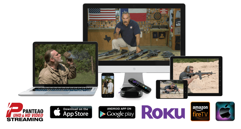
SureFire

Archive for the ‘Tac Apps’ Category

Inteliscope PRO+ Rifle Mount For Seek Thermal’s CompactXR Camera Now Shipping

Tuesday, December 22nd, 2015

Inteliscope PRO+ Rifle Mount For Seek Thermal’s CompactXR Camera Now Shipping
Product showcases the first integration of Seek’s CompactXR thermal image camera into a night vision scope at a price point of less than $500

Intelliscope Seek

SANDPOINT, Idaho, December 21, 2015 – Inteliscope LLC today announced it is now shipping the patented Inteliscope PRO+ Rifle Mount for Seek Thermal’s award-winning CompactXR thermal imaging camera. Inteliscope is the first company to integrate the Compact XR into a night vision scope at a price point of $497.

“With a highly successful pre-sale campaign for the Inteliscope PRO+ Rifle Mount for Seek’s CompactXR, we could not be more pleased to bring this product to market,” said Jason Giddings, Inteliscope’s CEO. “This product is such a great example of how Inteliscope is tapping into the latest technologies to help our customer base perform better and be safer in the field.”

“We are excited to see new innovations through the use of our products and SDK starting with Inteliscope’s mounting kit,” said Tracy Benson, VP of Global Marketing for Seek Thermal. “The idea that the Inteliscope team could quickly make an accessory suitable for their customers leveraging the same smartphone CompactXR device and Seekware SDK at affordable prices is remarkable.”  

The $497 Inteliscope PRO+ Rifle Mount bundle provides a quality night vision experience for a fraction of the cost of stand-alone units. The Inteliscope PRO+ mounts any smartphone to the shooters rifle and the Seek XR is integrated into the PRO+ mount using a snap-in bracket with a short extending cable to the phone, providing firm support to improve accuracy and eliminate issues with high recoil. Seek’s CompactXR can detect temperatures from -40° up to 626° Fahrenheit, with the ability to detect heat up to 1,800 feet away.

inteliscopes.com

www.thermal.com

GeoBallistics – Precision Shooting Wind Meter

Sunday, December 20th, 2015

WFPSM-01-front

GeoBallistics’ Precision Shooting Wind Meter is a plug-in wind meter for smartphones or tablets, designed for use with the BallisticsARC mobile app. When plugged into the audio jack of the device, it actively measures local wind velocity, with direction measured by the device compass. It is capable of detecting winds from 2 to 125 mph, with an accuracy of +/- 0.5%. The Precision Shooting Wind Meter requires no separate batteries to operate, and comes with a hard case for storage.

geoballistics.com/product/precision-shooting-wind-meter

Dazzle It App

Friday, September 11th, 2015

IMG_4127

You may be wondering why we’re covering a mobile device app inspired by and featuring the recent work of Sir Peter Blake, celebrated pop artist. Well, it all has to do with a bit of history in the application of camouflage.

320px-USS_West_Mahomet_(ID-3681)_cropped

This is an image of the USS West Mahomet, painted in Dazzle camouflage, which involves complex patterns of geometric shapes in contrasting colors, interrupting and intersecting each other. It was used by the British and United States principally during WWI, and was designed to make it difficult for enemy vessels to estimate a ship’s range, speed, and heading.

IMG_4130

The Dazzle It app allows users to ‘Dazzle’ any image available on their phone, or taken by their camera, by putting it through any one of various filters. This new camouflage pattern can then be applied to a variety of virtual ships and other watercraft which displays as a 3D model. As you can see in the images, we decided to go a bit more contemporary, utilizing a MultiCam base and putting it through a ‘Kaleidoscope’ pattern.

We then applied this pattern to various ships, including the HMS President.

FullSizeRender

There’s even an augmented reality aspect of the app, which allows you to anchor the ship of your choosing to a live background. We found this to be a little wonky in practice, but that might have something to do with trying to place a camouflaged ship on a camouflage background.

The Dazzle It app is available through both iTunes and the Google Play store for free.

itunes.apple.com/us/app/dazzle-it/id1022780620

play.google.com/store/apps/details?id=co.uk.corporationpop.dazzleships

Panteao Mobile App Available For Android Devices

Tuesday, March 24th, 2015

Columbia, SC, March 24, 2015 – The latest version of the Panteao Mobile App for Android Devices is now available for download. The new version of the app is a vast improvement over the previous release. The navigation and layout is completely revised and redesigned to make it easy to find the videos you wish to watch.

If you already have the Panteao app on your Android device, you will have to install the new version from the Google Play Store. Panteao website subscribers can use the mobile app to access and stream all the video titles available on the Panteao website using their same username and password from the Panteao site. Non subscribers can watch the video trailers and pro-tips.

Panteao

Link to Google Play Store: play.google.com/store/apps/details?id=com.app.panteao.productions

Time On Target iPhone App

Thursday, March 12th, 2015

Time On Target

Time On Target is a tactical training app available on the iTunes store. It features numerous Courses of Fire for pistol, rifle, or pistol + rifle, with built-in audio that calls out the drills to you. It also features multiple opponent profiles for you to test your skills against, and a built-in shot timer.

www.timeontargetapps.com

Tac Apps – Range Rings: New Map-Based Ballistics Calculator from Kopis Mobile

Tuesday, November 18th, 2014

Range Rings by Kopis Mobile is meant to be used when a shooter needs to quickly determine ballistics solutions in a number of directions, for multiple landmarks, instantaneously. This gives the shooter a quick mental reference as he moves between shots quickly. Other ballistics apps only provide a single shot solution.

Range Rings

When you start the app, your location is found and ballistics solutions are calculated based on the most recent weapon and weather information. The solutions, in the form of distance and drop, are then displayed in rings overlaid on a map of the immediate area.

You can add and edit your weapons configurations via the Weapons tab.

Weather (wind speed and direction, temperature, humidity) is automatically downloaded and used in the calculations, or edited manually on the Weather tab.

The appearance of the rings, including their units, color, spacing, and distance covered is all managed on the Settings tab.

Range Rings is available for iOS at itunes.apple.com/us/app/range-rings.

Kopis Mobile welcomes your feedback about additional features or problems. More information about Kopis Mobile can be found at www.KopisMobile.com.

New GeoSure Global App Provides Up-To-The-Minute Travel Safety Information

Saturday, September 20th, 2014

Monitor threat temperatures anywhere in the world: know when to walk or take a cab. when to leave at dusk or linger for a glass of wine. Today’s travelers can be empowered with GeoSure.

New York City, September 18, 2014 – It’s a beautiful world. It’s a treacherous world. Both facts are equally true. So how can travel – for business, for pleasure, for study – focus on the good, and steer clear of the bad? Today’s state-of-the-art answer is GeoSure Global, a new application designed under the leadership of Michael Becker, investor, entrepreneur and adventurer, and big data scientist, Dr. Donald Pardew, a thought leader in statistical risk modeling.

GeoSure Global balances the need or desire to travel with a personalized, analytically modeled assessment of safety and security in all the world’s travel zones. Its precision helps assure that travel adventures are the adventures one wants.

Today’s premier travel-risk assessment tool, the GeoSure app is unique in its ability to provide ultra-accurate and ultra-timely safety related advisories to travelers and travel-planners worldwide. Using sophisticated predictive analytics, GeoSure derives its exclusive “Threat Temperature” risk scores to quantify travel vulnerability anywhere in the world. It’s an instant, powerful, and highly personalized tool that is further enhanced by crowd-sourced updates from GeoSure’s community of global travelers and users.

Utilizing up-to-the-minute data drawn from hundreds of sources, including narrative data sources and shared intelligence from its own global community, GeoSure delivers vital travel information based on data and predictive analytic methodologies not available to most travelers. Sources include CDC, WHO, United Nations, State Department, Interpol, and data from many national and local authorities and updated global threat statistics. Virtually real-time reporting can include:

• Cultural, economic or geopolitical conditions that predict overall threats
• Political rallies that signal trouble or the absence of trouble
• Human rights violations
• Environmental contamination and cyber threats
• Conditions unfavorable to women (existing and emerging)
• Incidence of thefts and physical threats
• Local conditions that are attractive to visitors
• User reported “all-clears” in any travel zone

You can read the full release via .pdf here: soldiersystems.net/wp-content/uploads/2014/09/GEO_PR_09-18-14p.pdf

For more information, visit www.geosureglobal.com.

Prometheus Design Werx – Danger Ranger Bear App

Tuesday, September 2nd, 2014

screen568x568

The Danger Ranger Bear app by Prometheus Design Werx “…shares the how to’s, what’s, why’s, do’s and don’ts for your next outdoor adventure.” It offers constantly updating outdoors tips such as recipes for outdoor meals, how to read a topographic map, bushcraft, and gear maintenance, as well as gear reviews and campfire tales.

Currently available on iOS.

You can get it here: itunes.apple.com/us/app/danger-ranger-bear/id905506238?mt=8