FirstSpear TV

Archive for the ‘UAS’ Category

Silvus Launches StreamCaster 4200 Plus Drop-in Module

Tuesday, April 26th, 2022

Module Enables Plug-and-Play Compatibility with a Variety of Existing Subsystems

Los Angeles, California (April 25, 2022) – Silvus Technologies, Inc. (“Silvus”) today announced the launch of the StreamCaster 4200 Plus Drop-in Module, an embedded integration package for the StreamCaster 4200 Enhanced Plus at AUVSI Xponential 2022.

Equipped with a familiar mechanical footprint, hole pattern, and JST connectors for plug-and-play compatibility with a variety of subsystems currently on the market, the Module makes Silvus’ industry-leading MN-MIMO technology more accessible than ever. With the Module’s ability to quickly and easily integrate with existing hardware and cable interfaces, end users will benefit from:

• Reduced time to market and development investment

• Industry-best range, throughput, and robustness

• Low size, weight, and power consumption (SWaP)

• Dual bands in a single package without needing to swap hardware

• Spectrum Dominance waveform enhancements, including Anti-jam, LPI/LPD, and ToF Ranging

• Interoperability with StreamCaster (AN/PRC-169) Program of Record radios

“Unmanned system platform integrators demand options depending on end user preference and mission requirements,” said Jimi Henderson, Silvus Vice President of Sales. “The StreamCaster 4200 Plus Drop-in Module’s design approach provides integrators with the ability to quickly and easily upgrade their existing 802.11 based datalink with the extended range, reduced weight, and more advanced anti-jam and LPI/LPD capabilities that MN-MIMO provides, while ensuring interoperability with a growing number of US DoD Programs of Record where StreamCaster radios are being adopted.”

After meeting internal quality standards and successful completion of on-site client integration testing, the StreamCaster 4200 Plus Drop-in Module is now available. For more information or to request the full integration package, contact info@silvustechnologies.com or visit us at Booth 2414 at AUVSI Xponential.

AeroVironment Donates Over 100 Quantix Recon Unmanned Aircraft Systems to the Ministry of Defence of Ukraine and Territorial Forces

Thursday, April 21st, 2022

 • Donation is independent of other AeroVironment systems already being provided to Ukraine by the United States Government

• Donated Quantix Recon unmanned aircraft systems will ship this week with more to follow

• Operational training services for donated systems will also be provided at no cost

Quantix Recon is a powerful, simple-to-use unmanned aircraft system that delivers rapid, automated reconnaissance and hands-free data collection to operators. (Image: AeroVironment, Inc.)

ARLINGTON, Va., April 19, 2022 –AeroVironment, Inc. (NASDAQ: AVAV) a global leader in intelligent, multi-domain robotic systems, today announced it will donate more than 100 Quantix™ Recon unmanned aircraft systems (UAS) and operational training services to the Ministry of Defence of Ukraine and territorial forces amid the ongoing war against Russia. The donation was presented to the Ambassador and the Defence Attaché at the Embassy of Ukraine by AeroVironment chairman, president and chief executive officer Wahid Nawabi during a face-to-face meeting last week.

“As the Ukraine military’s fight to protect their homeland and defend their nation’s freedom against Russia’s invasion intensifies, their need for solutions that can offer force protection and force multiplication capabilities continues,” said Nawabi. “This donation will provide operators with a tool that can fly undetected by enemy forces and unaffected by radio frequency jammers to deliver accurate and rapid reconnaissance of remote, inaccessible areas of the dynamically changing battlefield.

“Using the actionable intelligence gathered by the Quantix Recon, operators can conduct quick mission planning and verification to help keep Ukrainian ground forces out of harm’s way. AeroVironment is honored to support the people of Ukraine,” Nawabi added.

AeroVironment’s Quantix Recon UAS is a lightweight, easily deployable, fully automated reconnaissance solution that provides on-demand actionable intelligence using high-resolution, georeferenced terrain, vegetation and infrastructure imagery. With its unique hybrid vertical takeoff and landing (VTOL) design, Quantix Recon combines the VTOL advantages of a multirotor drone with the range, speed and efficiency of a fixed-wing unmanned aircraft. Featuring fully automated flight operation, the UAS can survey up to 1.6 square kilometers (0.6 square miles), or 20 linear kilometers (12.4 miles), per 45-minute single battery flight.

Delivery of the Quantix Recon UAS is independent of other AeroVironment tactical missile systems and UAS already being provided to Ukraine by the United States Government. The first half of the donated Quantix Recon UAS shipment is expected to be delivered this week with operational training commencing immediately.

DroneShield Launches DroneSentry-C2 Command-and-Control System in Partnership with Location Intelligence Provider Nearmap

Friday, April 8th, 2022

DroneShield, an Australian/US global leader in Artificial Intelligence based platforms for protection against advanced threats such as drones and autonomous systems, has today announced an enhanced version of its DroneSentry-C2 Command-and-Control software, in partnership with location intelligence firm, Nearmap. Nearmap provides city-scale 3D content, artificial intelligence data sets, geospatial tools, and high-resolution aerial imagery in Australia, New Zealand, and North America.

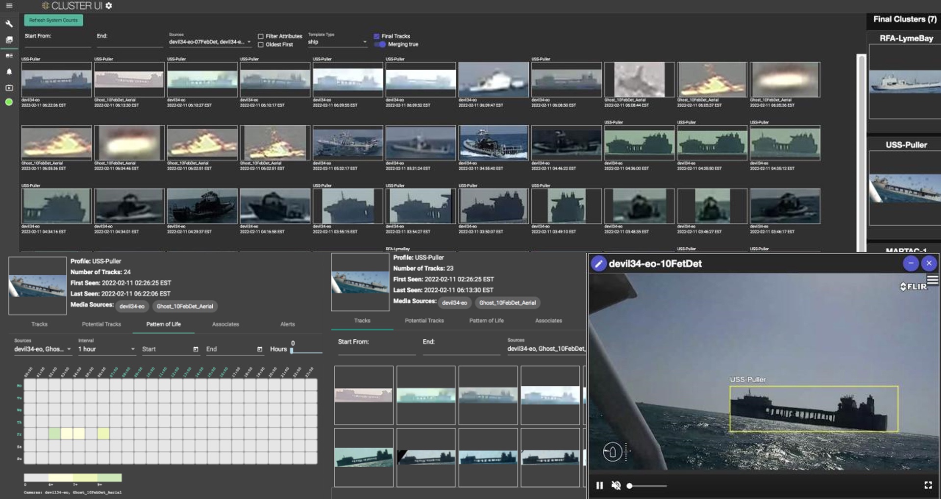
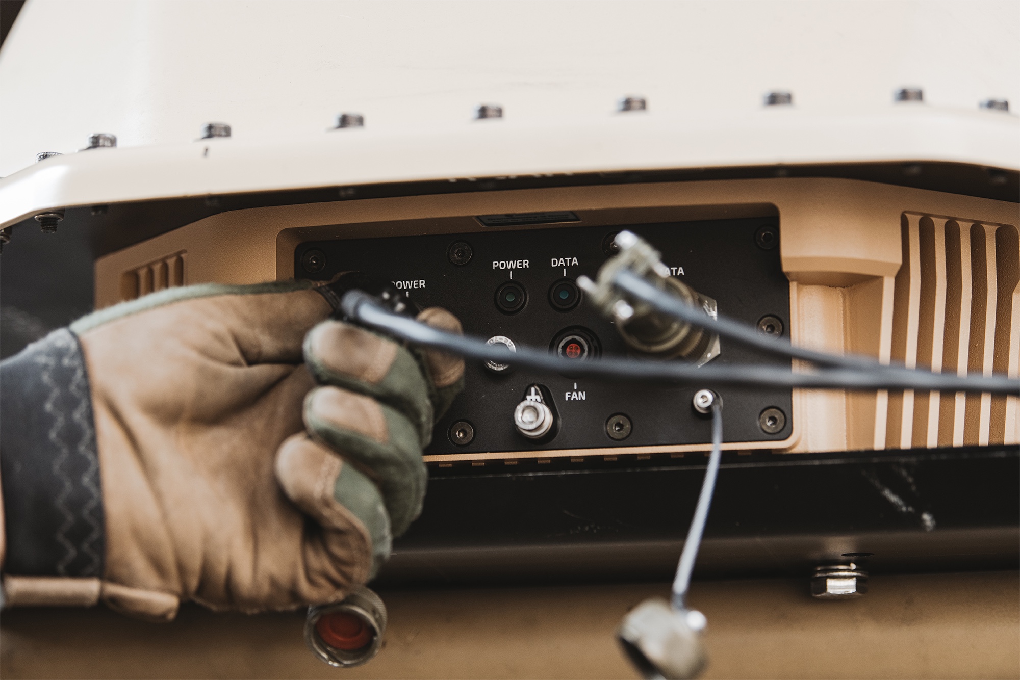
DroneSentry-C2 provides an intuitive and feature-rich software platform, providing counter-UAS awareness and reporting capability. It integrates both DroneShield and third-party C-UAS sensors and effectors. Those include multiple AI-enabled sensing and tracking products, such as RfOne long-range direction-finding sensors for UAS detection and tracking, and camera-agnostic DroneOptID optical/thermal camera AI software.

DroneSentry-C2 will come with a standard mapping solution for cost-sensitive customers, and an optional Nearmap mapping upgrade for best-in-class mapping data for high-performance environments, such as Government, intelligence, Homeland Security and defence markets, when precision and quality are critical.

The system receives regular secure software updates, capitalising on years of DroneShield’s extensive experience in the C-UAS arena.

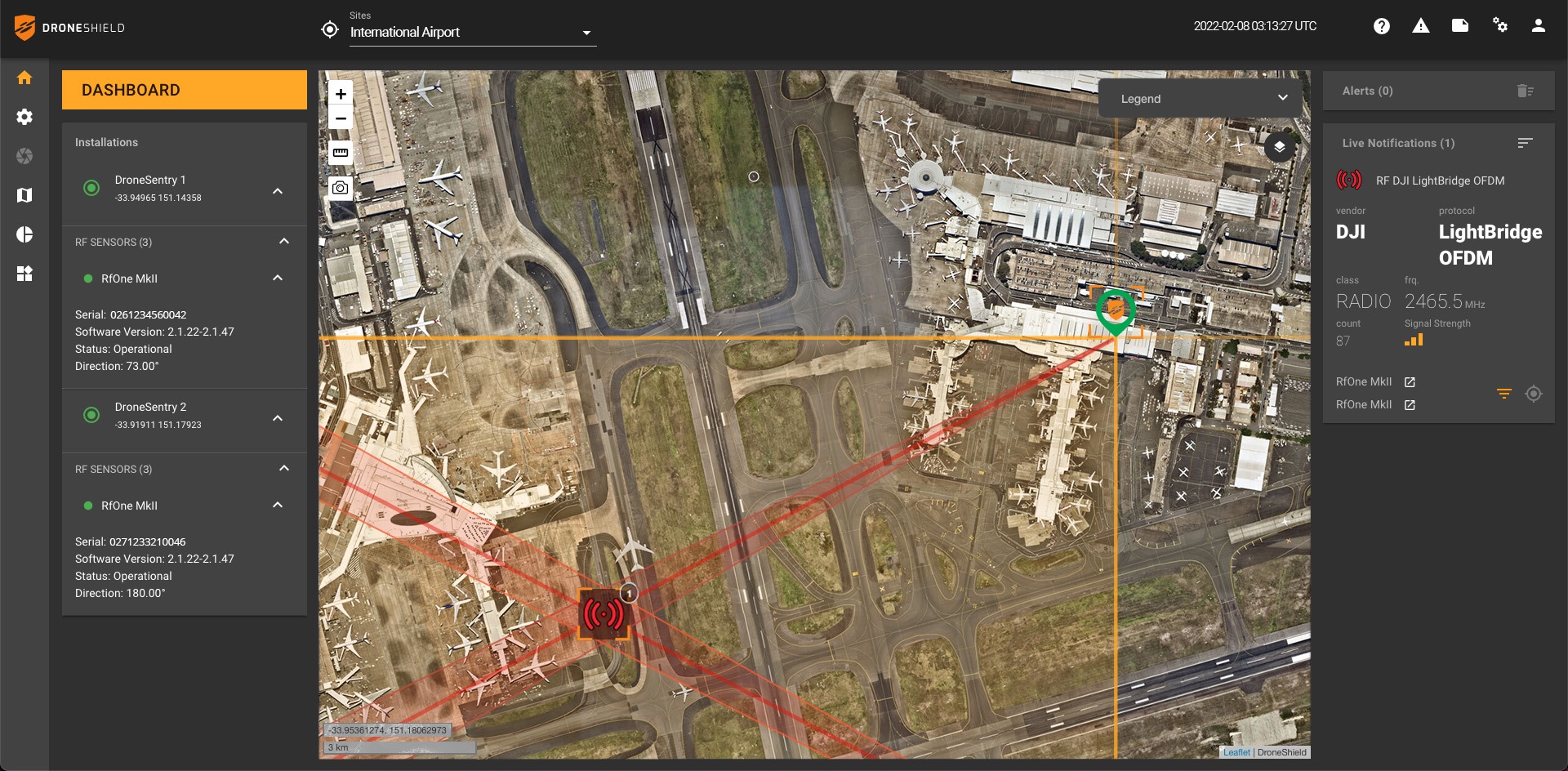
DroneSentry-C2 with Nearmap location data

The software comes as an on-prem, air-gapped solution which focuses on intelligence, Homeland Security and defence users, or secure cloud for enterprise customers. The on-prem solution also includes a high-grade physical server. Both options come with regular mapping updates, including ability for the user to load own maps, for sensitive locations.

Oleg Vornik, DroneShield CEO, commented, “One of DroneShield’s differentiators is that we are both a sensor manufacturer and an integrator. Providing a streamlined and standardised hard/software bundle that gives our user community an easy to deploy and run command-and-control software, will be critical, as more fixed and pop-up site users seek to deploy counter-UAS products. Importantly, the offering is already validated by deployments such as US Air Force and Australian Army, amongst number of other tier 1 end users globally.”

Dr Rob Newman, Nearmap CEO and Managing Director, said, “Our customers tell us they prefer Nearmap because of the quality, city-scale coverage, and currency of our location intelligence offering. Combine this market-leading geo-spatial capability with DroneShield’s innovative software, and the ability to defend against the threat of autonomous aerial vehicles, including drones, is even more powerful.

“Nearmap continues to drive innovation in the use of geo-spatial data and tools. This includes harnessing location intelligence to help organisations plan smart cities of the future, support the growth of greener spaces, and assist recovery efforts after major natural disasters.”

DroneShield Achieves UK MOD SAPIENT Compliance

Wednesday, April 6th, 2022

DroneShield Limited (ASX:DRO) (“DroneShield” or the “Company”) is pleased to advise it has reached compliance with UK Ministry of Defence (UK MOD) SAPIENT format. SAPIENT is a common operating format for defence devices (with similar principles to the US Department of Defense ATAK system), originally developed by the UK’s Defence Science and Technology Laboratory (DSTL). It was since adopted as the standard counter drone communication system in the UK.

SAPIENT offers a standard approach for AI and autonomy in networked multi-sensor systems in security and defence, and is being evaluated as a potential NATO standard for counter-drone systems.

Additional information on SAPIENT is available at www.gov.uk/guidance/sapient-autonomous-sensor-system

Going forward, DroneShield’s AI-enabled counterdrone/C-UAS RfPatrol, RfOne, and DroneSentry-X products now have the capability to provide a SAPIENT compliant output.


Image: DroneSentry-X system, now with SAPIENT interoperability

Oleg Vornik, DroneShield CEO, commented, “In the current challenging geopolitical environment, DroneShield continues to substantially progress our engagement across the NATO militaries, and specifically UK, alongside Australia and the US. We have on-the-ground team members in all 3 countries, supported by a network of highly capable local partners – in the case of UK, our partner is BT with its substantial defence credentials, as well as being a household name in the UK market.”

“Compliance with the SAPIENT format was driven by end-user requests from our UK and European militaries. It ensures our networked devices are plug-and-play compatible to the common operating format of other devices and systems of those end-users. We are currently involved in meaningful acquisition tender processes with UK and European end-users, which require this compliance as part of the deployment.”

Short Battery Life: A Drone’s Worst Enemy

Tuesday, March 22nd, 2022

IARPA awards $10.2 million for battery research to a team of performers led by Rutgers University for the RESILIENCE program

CAMBRIDGE, MA—March 23, 2022—Sensors and small aerial drones are touted as force multipliers for the military. Drones, known to specialists as unmanned aerial vehicles (UAVs), serve as the eyes and ears for combat and surveillance operations while keeping soldiers and intelligence personnel out of harm’s way.

UAVs can be configured to detect weapons, track troop movements and even pick up trace amounts of chemicals. But a key component that has long stymied UAVs is an adequate power source: aerial drones typically cannot fly for as long or as well in demanding operational conditions as many missions require.

Now scientists and engineers are developing a power source for UAVs that can better withstand conditions such as large temperature fluctuations, vibration and shock. The new tech incorporates recent advances in electrochemistry, microelectronics and packaging that combine for novel energy storage. The aim is to create reliable power solutions for missions conducted in extreme and challenging environments—and potentially triple battery life over best-in-class lithium-ion.

Rob Doe, an energy storage expert and microsystems integrator at Draper, says improving a drone’s power supply, or battery, is possible given recent advances in science and technology. “A battery that doubles or triples the energy density while meeting all other necessary performance requirements is well beyond the current performance of commercial solutions, but is within reach of the developer community,” Doe said.

Doe and his colleagues at Draper are contributing to the development of sensors and UAVs as part of a team recently selected by the Intelligence Advanced Research Projects Activity (IARPA). Led by Rutgers University, the team is developing portable power solutions for IARPA’s Robust Energy Sources for Intelligence Logistics In Extreme, Novel and Challenging Environments (RESILIENCE) program.

Battery cell development, using rechargeable lithium metal, is headed by Glenn Amatucci, Ph.D., professor of materials science engineering and director of the Energy Storage Research Group at the Rutgers School of Engineering. Draper’s primary contribution is to leverage its expertise in custom microelectronics, packaging and systems integration to optimize the energy storage system output, meet stringent size requirements and accelerate adoption of Rutgers’ energy storage solution.

The team has set a goal of developing a power source for drones, small sensors and portable devices that exceeds that of rechargeable lithium-ion batteries and single-use legacy lithium batteries. The team is working to create new electrochemical energy storage solutions, and lay the foundation for using rechargeable lithium metal in the power source they create. The vision is to extend battery life and design a battery that can be charged and discharged thousands of times.

IARPA says the aim of the RESILIENCE program is to develop “portable power solutions for electronics that can operate under the demanding operational conditions experienced by intelligence community officers.” If successful, the effort will provide power sources to extend the function of unmanned aerial vehicles (UAVs) with vertical takeoff and landing capability and unattended electronic devices, which must operate in extreme environmental conditions for years.

The company has previously applied its multidisciplinary engineering capabilities to a variety of related programs including to tiny, robust communications and navigation devices; persistent surveillance systems; and navigation software for drones.

www.draper.com

This publication was supported by a subaward from Rutgers, the State University of New Jersey, under Award No. 2021-21060200003 from the Office of the Director of National Intelligence – IARPA.

Any opinions, findings, and conclusions or recommendations expressed in this publication are those of the author(s) and do not necessarily reflect the views of Rutgers or those of the Office of Director of National Intelligence – IARPA.

DroneShield Receives Its Initial GSA Order

Friday, March 18th, 2022

DroneShield is pleased to advise it has received its initial order via a GSA schedule from a U.S. Government law enforcement and public safety agency.

GSA Schedule (U.S. General Services Administration, or also referred to as Multiple Award Schedule (MAS) and Federal Supply Schedule) is a United States long-term government-wide contract with commercial firms providing federal, state, and local government buyers access to more than 11 million commercial supplies (products) and services.
 
DroneShield products are available for U.S. State, local, and tribal governments through GSA Multiple Award Schedule under Special Item Number (SIN) 334290, or alternatively via GSA’s Cooperative Purchasing Program.
 
The public safety project includes multiple DroneSentry-C2, DroneShield’s enterprise command-and-control system, DroneShield  RfOne long-range UAS direction finder sensors, and RadarZero small form-factor radar.
 
Matt McCrann, CEO of DroneShield LLC (DroneShield U.S. subsidiary), commented, “State, local and tribal governments have a growing need for drone detection solutions. Often the procurement process presents complexity for Government end users to field the capabilities needed across their organizations. Our availability on the GSA Schedule provides an easy-to-use contract vehicle for them to acquire this capability and field effective counterdrone solutions. With DroneShield solutions now on GSA, Government agencies have the confidence of receiving proven products at competitive pricing.”
 
Oleg Vornik, DroneShield CEO, added, “We welcome onboard our first customer through GSA, and anticipate for this to be one of numerous U.S. deployments. Purchasing via GSA is also a great indicator of increasing maturity and scale of the C-UAS market, whereby the acquisitions move from experimental budgets to streamlined large acquisition processes.”
 
Further information about DroneShield’s law enforcement C-UAS solutions can be found at www.droneshield.com/law-enforcement.

TEKEVER AR5 Successfully Integrates Overwatch Imaging’s PT-8 Oceanwatch Payload

Monday, March 7th, 2022

World Defense Show, March, 7th 2022 – TEKEVER, the European leader in Maritime Surveillance, and US-based Overwatch Imaging, a leader in airborne imaging systems for both piloted aircraft and drones, have successfully integrated the PT-8 Oceanwatch payload on the TEKEVER AR5 UAV, adding 360º automatic small target detection capabilities to the system.  The news was announced in Riyadh, during the World Defense Show.

VIDEO – we.tl/t-nlUQDi6ULy

World Defense Show, March, 7th 2022 – TEKEVER, the European leader in Maritime Surveillance, and US-based Overwatch Imaging, a leader in airborne imaging systems for both piloted aircraft and drones, have successfully integrated the PT-8 Oceanwatch payload on the TEKEVER AR5 UAV, adding 360º automatic small target detection capabilities to the system.  The news was announced in Riyadh, during the World Defense Show.

“The Overwatch Imaging payload enhances the situational awareness capabilities of the TEKEVER AR5, namely for 360º automatic detection of small targets. Like a radar, the sensor automatically detects targets, and allows the operator to recognize and validate the information. Because it’s based on visual data, the PT-8 Oceanwatch allows us to consider very significant information for automatic classification, such as the color of the targets. We believe it will greatly help us improve mission effectiveness”, said Tiago Nunes, TEKEVER’s Director of Products.

“The TEKEVER AR5 UAV is a very capable system with a large payload capacity and multiple state-of-the-art sensors operating simultaneously,” said Greg Davis, CEO of Overwatch Imaging. “Our PT-8 Oceanwatch enhances the system capabilities with AI software, creating an even more powerful maritime patrol UAS.”

The AR5 is a Medium-Altitude/Medium-Endurance, Fixed Wing UAS designed for missions such as land and maritime surveillance, extended patrols, and search & rescue. It is capable of BRLOS (beyond radio line of sight) by way of satellite communications. The AR5 offers superior performance with reduced operating costs, using a satcom terminal and multiple sensors that operate simultaneously.  

The Overwatch Imaging PT-8 Oceanwatch is a passive image-based radar system that enables much faster search for small or long-range maritime objects compared to traditional maritime patrol systems that use video or human-based search alone. Oceanwatch combines multiple high-resolution cameras and AI-enabled processing at the edge to automatically identify objects in water during the day and at night.

www.tekever.com

DroneShield – Teledyne FLIR Collaboration and First Marquee Customer

Thursday, March 3rd, 2022

DroneShield Limited (ASX:DRO) (“DroneShield” or the “Company”), a global leader in artificial intelligence solutions for advanced unmanned threats, and Teledyne FLIR, a world leader in intelligent sensing solutions for defense and industrial applications, part of Teledyne Technologies Incorporated, have announced a collaboration to offer a joint sensing and mitigation solution for unmanned aerial threats.

As part of the collaboration, Teledyne FLIR is extending its counter-UAS thermal imaging sensing technology to the DroneShield platform, which has developed and applied its powerful AI and machine learning software algorithms via radiofrequency (RF) sensing and computer vision technologies. The addition of Teledyne FLIR thermal camera hardware and expertise will enable military customers to improve detection, including identifying and tracking numerous unmanned threats in the thermal and RF spectrums at considerable range, providing a unique and ground-breaking capability offered within a single system.

The combined sensor offering has secured an initial marquee customer, a major Western military agency, which will be deploying the combined system at one of the best-known military testing ranges in the world. 


Image: DroneShield DroneSentry-C2 command-and-control system with Teledyne FLIR thermal imaging sensing technology

Oleg Vornik, DroneShield CEO, commented, “With the ability to detect, identify, and track threats in the thermal and RF spectrums via powerful artificial intelligence algorithms, DroneShield and Teledyne FLIR offer a unique and differentiated capability, poised to augment a substantial number of multi-sensor C-UAS systems globally. We are thrilled to enter this collaboration. We are already working together on multiple tier-one global opportunities, including having jointly secured the initial marquee DoD customer for our combined offering, which incorporates our radiofrequency sensors and DroneSentry-C2 command-and-control system. The joint system’s capability, plus the combination of Teledyne FLIR and DroneShield channels to market, strongly positions the combined system for a meaningful-scale rollout with Five Eyes partners and approved allies globally.”

“The unmatched Teledyne FLIR thermal imaging hardware and analytics for counter UAS, along with DroneShield’s RF sensors and unique AI software algorithms, provide a differentiated and substantial value-add to allied defence departments,” said Kai Moncino, Director of Global Business Development – Solutions, Teledyne FLIR. “Teledyne FLIR is thrilled to work closely with DroneShield to secure our first marquee proof-of-concept DoD customer at the iconic deployment location, and we look forward to expanding on our collaboration with DroneShield globally.”


Image: Teledyne FLIR thermal image sensor at a DroneShield facility

Further Information
Oleg Vornik
CEO and Managing Director 

Email: oleg.vornik@droneshield.com