TYR Tactical

Archive for the ‘ISR’ Category

MKS Announces Ophir Long Range, Ruggedized 60-1200mm f/4 Continuous Zoom Lens for Cooled MWIR Cameras

Tuesday, April 5th, 2022

Detection ranges exceed 28km for security and survaillance, and C-UAS extended observation systems

April 5, 2022 – Andover, MA – MKS Instruments, Inc. (NASDAQ: MKSI), a global provider of technologies that enable advanced processes and improve productivity, has announced the Ophir® SupIR 60-1200 MWIR f/4 lens, the latest addition to the company’s series of lenses designed for SXGA/HD 10µm and 15µm VGA pitch FPA (focal plane array) cooled MWIR cameras. This new, high precision lens is equipped with an automated zoom interface and continuous zoom to provide a sharp and clear image across the entire field-of-view and throughout the full zoom range. This makes it ideal for the demanding requirements of Counter Unmanned Systems (C-UAS) applications and long range observation and surveillance systems.

“The SupIR 60-1200mm MWIR f/4 lens is a game changer for homeland security and defense applications,” said Dr. Kobi Lasri, General Manager, Ophir Optics Group. “The extended observation range, high performance continuous zoom capabilities, and ruggedized design allow for early and accurate identification and tracking of fast-moving targets without losing sight.”

The Ophir SupIR 60-1200mm f/4 has a horizontal field-of-view (H-FOV) of 0.3°-8.6°. It is the newest addition to the SupIR SXGA/HD 10µm detectors compatible series of lenses which are designed to withstand harsh environmental conditions, providing an operating temperature range from -32ºC to +85ºC. These lenses features Ophir’s world-renowned abrasion-resistant, anti-reflective (AR) coatings; IP 67 sealing; and a mechanical design that withstands severe shock and vibration. They are designed for ease of mechanical and electronic integration using Ophir’s standard software for optimal integration, calibration, and field operation. In addition, the lenses are equipped with zoom controller features for continuous zoom with focus retention, automatic focus compensation throughout temperature and zoom ranges, close objects focus mode, focus blurring for NUC calculation, and full manual and automatic control of zoom and focus positions.

Availability

The SupIR 60-1200mm MWIR f/4 lens is available now. OEM prices available on request.

Product Data Sheet

SupIR 60-1200mm f/4 lens

Ophir long-range product family brochure

Pennsylvania Guard First Guard to Field New SIGINT System

Tuesday, March 29th, 2022

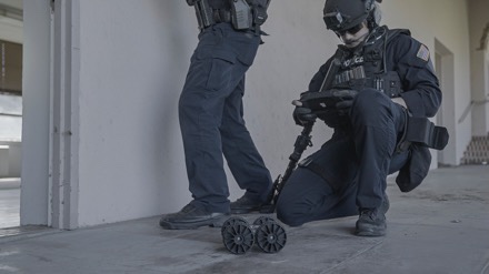
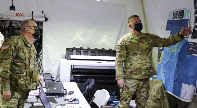
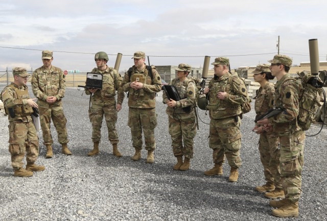
FORT INDIANTOWN GAP, Pa. — The Pennsylvania National Guard is the first National Guard in the country to field the new Tactical Dismounted Electronic Warfare and Signals Intelligence (TDEWS) system.

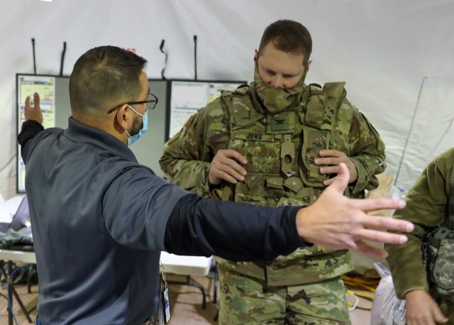
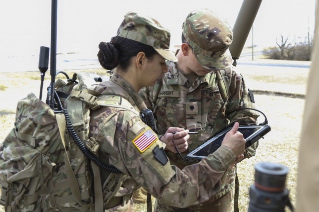
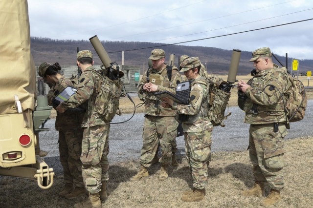
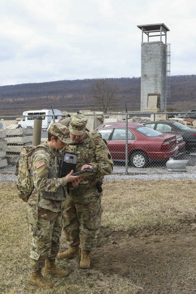
Eight Pennsylvania National Guard Soldiers trained at Fort Indiantown Gap March 13-17 on the TDEWS, which filled a significant gap in the training of Soldiers in the intelligence Military Occupational Specialties. Signals Intelligence advisers from the Army National Guard Technical Control and Analysis Element and the Intelligence and Electronic Warfare Program of the Mission Training Complex facilitated the training.

“This system adds a huge amount of value to our intelligence capabilities,” said Warrant Officer Trevor Burgess, a signals intelligence analysis technician with 28th Infantry Division, the Pennsylvania Guard’s senior SIGINT technician. “Soldiers train for six months to acquire the MOS, then when they get to their units here in Pennsylvania, they didn’t have this equipment to train on and the support of full-time subject matter experts that the Army National Guard G2 provides, so this does improve our intelligence capability.”

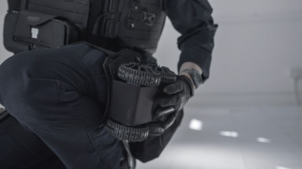
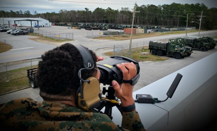
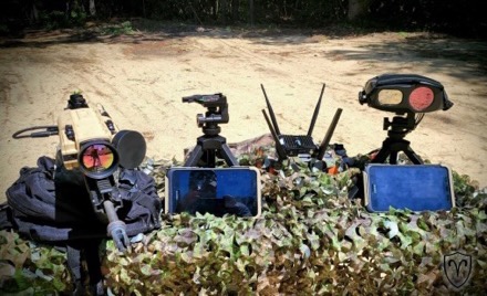
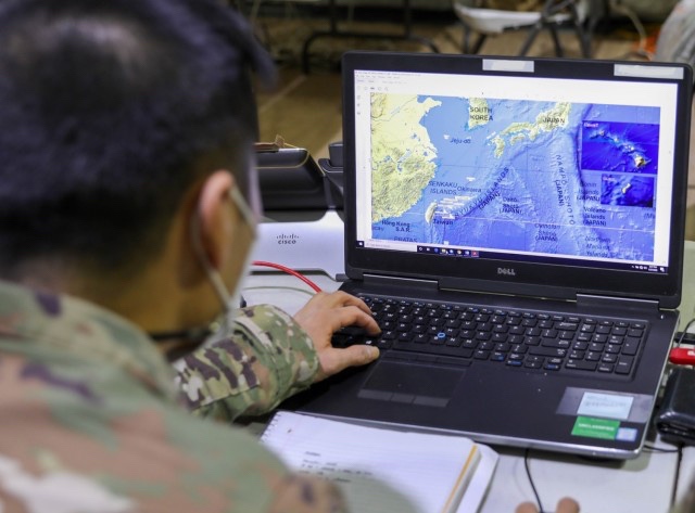
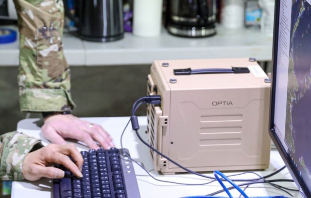
The TDEWS is a dedicated, all-weather, tactical electronic warfare system providing force protection and situational awareness to commanders at any echelon.

“We went from classroom instruction to hands-on setting up and tearing down the system over and over, to using it in a controlled dismounted environment, and then in the past two days, we’ve been able to pack it up in our special man packs we were issued for the system and actually come out here and work with trainers who built situational training exercise lanes for us to train on,” said Sgt. Emily Rivas, a cryptologic linguist with the 103rd Brigade Engineer Battalion, 56th Stryker Brigade Combat Team, 28th Infantry Division.

The 56th SBCT will be doing a rotation at the National Training Center at Fort Irwin, California, this summer. The training will ensure these Soldiers can employ this new equipment during the brigade’s validation exercise and can execute their mission as they would on the battlefield, Burgess said.

“The thing with this system that makes it so nice for our training is that we’re able to just fire it up and use it whenever we want at any training site,” said Rivas. The previous system required a lot of coordination and approvals, which became cumbersome.

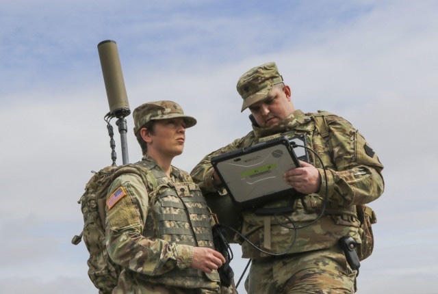
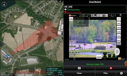
During the recent training at Fort Indiantown Gap, the eight Soldiers were divided into two-person teams to locate trainers posing as enemy forces at a rubble pile. Rivas’ team was the first to locate their target.

“We were able to lock it down really fast, locating the enemy really quickly and let the other teams know where they were and how they were communicating,” she said. “It felt really good to actually be able to see the system working and how it all comes together.”

“As of right now, I’m feeling very good about it,” said Sgt. Joe Falcone, a cryptologic linguist with the 103rd Brigade Engineer Battalion, 56th Stryker Brigade Combat Team, 28th Infantry Division. “We have a total of eight days so far training on this equipment, just due to the nature of being in the National Guard and that it was only fielded to us at the beginning of January, but every single day I feel leaps and bounds better.”

Falcone said he didn’t feel as comfortable with the device earlier in the week, but this event significantly improved his confidence in advance of the upcoming rotation.

“The NTC rotation will allow the Soldiers to actually utilize the skills that they train hard in, and use that to improve the intelligence footprint, the intelligence picture and make the overall mission a success,” said Burgess.

By SSG Zane Craig, Joint Force Headquarters – Pennsylvania National Guard

OverWatch by Aries Defense

Monday, February 14th, 2022

SupplyCore has been out looking for novel C5ISR* technologies and showed me the Overwatch System from a company right in my backyard. Aries Defense is based here in the Tidewater of Virginia and was founded by a small team of coders who specialize in rapid integration of existing systems into distributed networks.

OverWatch began service with the USMC but has rapidly been spread to other services. It is a TLR9 system which is a LOW voltage edge deployable video surveillance platform used to gain close-in situational awareness.  OverWatch will present a “live” view of the battlespace from a fixed and/or concealed position and provides live full motion video over any network.

OverWatch is network agnostic. They have integrated with LTE, SATCOM, Ethernet, and any Tactical radio such as Trellisware, Harris, DTC, Thales, Silvus, Persistent, etc.

OverWatch is also camera agnostic.  It will ingest any digital or analog video stream.  Aries Defense provides Canon/Nikon lens adaptors which allow maximum compatibility with existing lens kits.

Finally OverWatch is integrated into ATAK, WinTAK, and MCH as well as Aries Defense’s own StandAlone App.

Aries Defense products are available for unit and agency purchase through SupplyCore.

*Command, Control, Communications, Computers, Combat Systems, Intelligence, Surveillance, and Reconnaissance

Portable Servers Enhance Army Geospatial Intelligence Training

Saturday, February 12th, 2022

FORT KNOX, Ky. — The Army Geospatial Center has assisted in further modernizing the 412th Theater Engineer Command’s Engineer-Focused Intelligence Training, or ENFIT, geospatial intelligence procedures with two portable high speed imagery servers.

The OPTIA-produced “ammo can” and smaller-sized portable imagery server from TerraMaster provide Engineers with rapid access global map data without reliance on network speeds or bandwidth limitations. The unit connects a laptop to either device and pulls what they need directly from it, cutting down research and product development by as much as 50 percent.

Jorge Morales, Team Lead Geographer with the AGC Warfighter Support Directorate, stated that the AGC integrated both portable systems into the ENFIT program as of the third quarter of 2021, so the AGC anticipated units to send in results of their use shortly.

“The ‘ammo can’ has about 25 terabytes in storage,” he said. “That fits all of the geospatial maps with space to spare for more.”

Morales explained that the maps already on the devices varied depending on what engineers needed, but each were as detailed down to as much as half a meter. He said they provided a “hybrid solution” with both three dimensional and simulation capabilities.

Armed with comprehensive imagery of the entire world, regardless of depth or height, Army Engineers can precisely direct and reinforce U.S. military efforts for assured mission success. Further, at an estimated five pounds each, the servers prove an easy, more than acceptable burden for any unit.

ENFIT is a specialized course where Soldiers use updated geospatial analytic tools with rapid terrain analysis — geospatial data being facts about occurrences, objects and events that are associated with a particular location on Earth’s surface. These give engineer commanders proper foundational, geographical knowledge to make the right decisions as to where operations should take place.

Maj. Gen. Stephen Strand, 412th TEC Commander, emphasized that ENFIT provides new methods to improve top-tier planning for the Army Reserve.

“The ENFIT program significantly enhances the geospatial engineering capabilities of the [412th Theater Engineer Command],” said Strand. “It’s a great program to develop the bench needed to maintain proficiency for years to come.”

Col. Steven Hayden, 412th Theater Engineer Command Chief of Staff, concurred on Strand’s assessment, adding that ENFIT allows Soldiers to use geospatial analytic tools to provide commanders with terrain analysis that shape the battlefield and drive decision.

ENFIT continues in Alexandria, Virginia throughout 2022 with more classes that include these and more modernizing devices.

By MAJ William Allred and SFC Tony Foster, 412th Theater Engineer Command

Counting Elephants – The Hark-1 Radio

Saturday, January 1st, 2022

As Vietnam heated up, the Agency’s need for eyes on the Laotian panhandle increased beyond the support that could be provided by Thai PARU and RTSF advisors. As a result, the CIA was forced to look for other solutions to communicate with its illiterate Lao Theung road watching teams targeting the Ho Chi Minh Trail.

To tackle this problem, the Agency came up with a radio that used pictograms to communicate what a team saw. Crafted from a modified USAF survival unit, the Hark-1 or Hark Box was released early in 1967.

Note the depictions of armor, artillery, AAA, trucks, porters, soldiers, time of day, and direction of travel. The circular button at the center was used to transmit the tally of what was seen moving north and southbound on the trail to an airborne relay station. While the radio doesn’t appear to have a pictogram for elephants, it was given the affection moniker “the Elephant Counter” by Paramilitary Officers involved in the project. To avoid detection, the Hark road watching teams – sometimes numbering up to twenty-four road watchers on a target like the Mu Gia Pass – would be inserted via unmarked “Pony Express” CH-3s very far from their objective.

On the third slide you can see the Hark-1 with antenna deployed in front of Case Officer, Gene Norwinski during a briefing in Savannakhet. The project was wrapped up in 1969 having been overshadowed by a variety of Pentagon projects and new sensors and night vision capabilities like those present on the AC-130.

Written by @Immurement

Edgar Brothers to Deliver Fused Target Locator Solution to British Armed Forces

Wednesday, December 22nd, 2021

After a stringent tender process, Edgar Brothers are proud to announce the award of the multi-year contract by the UK Ministry of Defence to provide and support the British Armed Forces with the Fused Target Locator (FTL) solution for light reconnaissance operations.

The successful system put forward by the Edgar Brothers team includes a carefully selected collaboration of industry leading partners utilising SAFRANs JIM COMPACT Lightweight, multifunctional, long-range binocular system, supported by Forsberg’s MANTIS® Battle Management System, integrated applying EXSEL Groups extensive expertise.

The system integrates to optimise operation of the JIM Compact. This world-leading sensor is remotely controlled on the masthead or tripod from the operator’s MANTIS® software loaded end user device. Providing a lightweight, low signature, multi-sensor surveillance and target acquisition system; that is man portable, vehicle mountable and will detect, recognise and identify likely adversaries at range, which enables timely and effective decision making.

“We are immensely proud to have been selected to supply the FTL system to UK MoD. Along with our industry partners Safran, Forsberg and EXSEL we feel we have created a system that will give our troops the edge in the battlespace for many years to come. The award of this contract enables us to create more jobs “ here in the UK as part of our continued growth strategy.

Mike Newman – Director at Edgar Brothers

For more information, please contact pmd@edgarbrothers.com

TacJobs – USAF Special Reconnaissance

Friday, November 19th, 2021

Special reconnaissance Airmen are special tactics operators with unique training to conduct multi-domain reconnaissance and surveillance across the spectrum of conflict with focus on lethal and non-lethal air-to-ground integration of airpower.

Learn more at www.airforce.com/careers/detail/special-reconnaissance.

AeroVironment’s New Mantis i45 N Multi-Sensor Imaging Payload Delivers Advanced ISR for Nighttime Operations

Wednesday, November 17th, 2021

• Mantis i45 N provides maximum visibility during low-light or nighttime intelligence, surveillance, and reconnaissance (ISR) operations

• All-environment rated payload maintains similar footprint to battle proven Mantis i45, for fast in-field change-out of payloads between day and night operations

• No software updates required to Puma UAS avionics or ground control stations for legacy system compatibility


AeroVironment’s Mantis i45 N provides maximum visibility during low-light or nighttime intelligence, surveillance and reconnaissance (ISR) operations. (Image: AeroVironment, Inc.)

ARLINGTON, Va., Nov. 16, 2021 –AeroVironment, Inc. (NASDAQ: AVAV), a global leader in intelligent, multi-domain robotic systems, today introduced the Mantis™ i45 N, a multi-sensor nighttime imaging payload compatible with Puma™ 2 AE, Puma™ 3 AE and Puma™ LE small unmanned aircraft systems (UAS). Lightweight (905 g) and compact, the new Mantis i45 N joins AeroVironment’s expansive Mantis product line of micro-gimbals delivering high-quality video and imagery downlink to UAS operators.

Mantis i45 N is a dual-axis, gyro-stabilized, multi-sensor nighttime imaging payload designed for maximum visibility during low-light or nighttime intelligence, surveillance and reconnaissance (ISR) operations. The next-generation imaging system features improved long-wave IR (LWIR) thermal cameras with narrow-angle 32 mm and wide-angle 9.2 mm IR with 7.6x electronic zoom, allowing operators to capture high-resolution video at extended range. Designed for both superior night and low-light performance, the new imaging system also includes an upgraded 5-megapixel monochrome low-light camera sensor and high-powered 860 nm laser illuminator. Through its advanced suite of sensors, the Mantis i45 N payload allows Puma UAS operators to extend aircraft standoff distance for covert operations.

“Today’s battlefield is dynamic and UAS operators increasingly rely on multiple payloads to successfully complete their missions,” said Charles Dean, AeroVironment vice president for global business development and sales of UAS. “The new Mantis i45 N is a game changer during low-light or nighttime ISR operations, delivering increased situational awareness and advanced threat detection in any environment.”

Built on the trusted and battlefield proven Mantis i45, the enhanced night variant Mantis i45 N maintains the same housing form-factor, allowing for a quick and simple change-out of payloads between day and night operations. Plug and play operational, no software updates are required for Puma UAS avionics or ground control stations for legacy system compatibility. Mantis i45 N is also natively compatible with AeroVironment’s Crysalis™ next generation ground control solution. To learn more, visit: www.avinc.com/uas/payloads