Garmin unveils revolutionary Xero L60i laser rangefinder with superior optics, GPS and onboard mapping technology
Mark targets with Laser Locate and maneuver to them using high-resolution digital mapping, augmented reality and advanced navigation features for an immersive visual experience
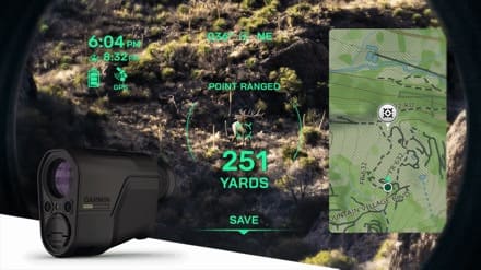
OLATHE, Kan./Jan. 20, 2026/ Garmin (NYSE: GRMN) is taking laser rangefinding capabilities to new horizons with the Xero® L60i. This GNSS-enabled rangefinding monocular combines premium optics with advanced technology and state-of-the-art sensors for an unparalleled rangefinding experience. With Xero L60i, users get a sharp, bright view through augmented reality technology that overlays graphics in full color, including distance, maps, navigation and more—all while ranging targets out to 3600 meters through 7X magnification.
See the Xero L60i laser rangefinder in action
“Xero L60i is a groundbreaking rangefinder that pushes the boundaries of what’s possible for rangefinding technology. Combining superior optic quality, robust mapping and integrated navigation features like Laser Locate, Sensor Locate and Visual Recall, Xero L60i represents what Garmin does best – integrating revolutionary new technology with rugged devices – to give hunters, wildlife enthusiasts, researchers, SAR teams and more the tools they can depend on to enhance their outdoor experience.”
—Susan Lyman, Garmin Vice President of Consumer Sales and Marketing
The Xero L60i difference
The Xero L60i is the first and only laser rangefinder with onboard map-based GPS navigational capabilities and a high resolution, multi-color display overlaid into superior optics. This enables features such as:
Digital Mapping: View current and ranged locations marked on topographic mapping and use the Xero L60i to navigate to them.
Smart Integration: Waypoints can be shared to the Garmin Explore™ App on a compatible smartphone, then shared to a compatible Garmin handheld or wearable device using the Garmin Share functionality.
Laser Locate™: Leverage the range taken, along with compass heading and GPS coordinates, to project a waypoint on the display, then navigate to the waypoint through directional cues.
Sensor Locate: When the desired object is too far to range, built-in GPS, compass, inclinometer and mapping can calculate and project a waypoint of the intended target, allowing estimated ranges to targets several miles away.
Visual Recall: When moving to a new vantage point after ranging, use on-screen cues to steer your visual field back to a previously marked waypoint.
Superior optics
Purpose-built to give users the highest quality optical experience, Xero L60i features fully multicoated, low-dispersion glass, which provides razor-sharp optics with a flat field of view, accurate color fidelity and superior light transmission. The 32mm objective lens was intentionally chosen to provide a generous exit pupil, low-light performance, and superior field of view. During dawn or dusk use, an ambient light sensor automatically controls display brightness, ensuring the visual scene remains clear.
Precise long-distance ranging
Range animals to 2,775 meters and trees to 3,600. In optimal low-light conditions, the Xero L60i makes it possible to reach as far as 7,000 meters to retro reflective objects while achieving accuracy of +/- .25 meters under 1,000 meters and +/- 1 meter out to maximum laser-ranged distances.
Onboard ballistics
Get access to the onboard Applied Ballistics Ultralight™solvervia the AB Quantum app for all the data needed to make the perfect shot. Thanks to the GPS positioning, temperature, compass, and barometric sensors, the Xero L60i delivers an accurate ballistic solution for short- and long-range shooting, including the effect of Coriolis on the point of impact. Change profiles, setup target cards, and more, all with a few button taps. Archers will appreciate the all-new arrow ballistics solver, which provides details on angle compensated range, max arrow height, and the arrow entry angle at the target.
The Xero L60i is built to withstand the harsh outdoor conditions with an IPX7 water-resistance rating and runs on two AAA lithium batteries. See it on display at the Garmin booth, #10119, during SHOT Show 2026. It’s available now for $2,499.99.