FirstSpear

Archive for the ‘TAK’ Category

Red Cat Collaborates with Safe Pro Group to Embed Real-Time AI-Powered Threat Detection Onboard the Black Widow Drone Platform

Tuesday, September 16th, 2025

SAN JUAN, Puerto Rico, Sept. 15, 2025 (GLOBE NEWSWIRE) — Red Cat Holdings, Inc. (Nasdaq: RCAT) (“Red Cat” or the “Company”), a U.S.-based provider of advanced, all-domain robotic solutions for defense and national security, today announced a strategic collaboration with Safe Pro Group Inc. (Nasdaq: SPAI) (Safe Pro), a leading provider of artificial intelligence (AI)-computer vision technologies.

Through this collaboration, Safe Pro’s patented AI-powered image analysis technology will be embedded into Red Cat’s Black Widow drones, enabling U.S. and allied ground personnel to rapidly identify and locate more than 150 types of explosive threats including landmines, anti-personnel mines, cluster munitions, and unexploded ordnance (UXO) in real-time.

The integration will allow Safe Pro’s Object Threat Detection (SPOTD) system to process real-time 4k video onboard the Black Widow at the tactical edge and deliver live threat data directly to military situational awareness platforms such as the U.S. Army’s Tactical Assault Kit (ATAK) software ecosystem, enhancing and accelerating decision making critical to mission success.

The Black Widow will also integrate with Safe Pro’s new SPOTD Navigation, Observation and Detection Engine (NODE), a powerful, edge-based solution designed to process, map and share mission critical information collected by drones. Supporting rapid deployment at the edge, the SPOTD NODE “kit” enables end users to collect real-time visual data, receive threat alerts, and utilize that imagery to create 2D and 3D interactive maps and plot hazard detections. This capability provides enhanced situational awareness, supporting a wide array of ground missions even in connectivity-denied environments.

Powering Safe Pro’s SPOTD technology is one of the world’s largest real-world landmine and UXO datasets consisting of high-resolution imagery and GPS-tagged geospatial data encompassing over 1.88 million drone images analyzed to date, and 34,200+ threats identified across 8,119 hectares (20,062 acres) in Ukraine.

“The Black Widow continues to distinguish itself as a leading sUAS platform for defense and security, ideally suited to supporting the evolving needs of the U.S. Army and its global allies. By incorporating field-proven innovations such as Safe Pro’s unique AI-powered threat detection technology, we continue to redefine the future of force protection and battlefield awareness,” said Jeff Thompson, Red Cat CEO.

“As demonstrated in Ukraine, the battlefield is dramatically evolving, establishing a critical need to provide today’s warfighter with access to enhanced, real-time situational awareness. By harnessing the power of the Black Widow with Safe Pro’s battle-tested threat detection technology, we have created a platform that can uniquely support the needs of the U.S. Army for real-time battlefield intelligence, and we look forward to bringing this capability to our warfighters,” added Dan Erdberg, Chairman and CEO of Safe Pro Group Inc.
PureTech Systems and Clear Align Partner to Deliver Advanced Autonomous Security and Command-and-Control for US Air Force Tactical Security System

Friday, August 22nd, 2025

Phoenix, AZ — August 18, 2025 — PureTech Systems®, a leader in AI-boosted geospatial video analytics and command-and-control solutions, announced its role in a joint effort with Clear Align to deliver a rapidly deployable perimeter security solution for the U.S. Air Force’s Tactical Security System (TSS).


Awarded under a seven-year, $199 million contract, this modular, scalable system is designed to enhance base and perimeter protection for forward-deployed installations, airfields, and emergency missions worldwide. It integrates electro-optical and infrared cameras, radar, and advanced AI into a unified, autonomous command-and-control platform. Designed for challenging and remote environments, the solution enables operators to detect, classify, and track threats in real time — with or without direct operator intervention.

Autonomy + Command and Control

PureTech’s technology brings autonomous detection, classification, and tracking of potential threats — including people, vehicles, unmanned aerial systems (UAS), and watercraft — with the ability to seamlessly cue operators or trigger automated responses. The system’s open architecture command-and-control platform provides complete situational awareness across all deployed sensors, reducing cognitive load and increasing mission effectiveness.

ATAK Integration for Real-Time Field Operations

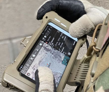
Incorporating Android Tactical Assault Kit (ATAK) compatibility ensures that situational awareness extends beyond the operations center. With ATAK integration, field personnel receive live intelligence and sensor alerts directly on mobile devices, enabling distributed teams to coordinate in real time and act with precision.

Rapid Deployment for Any Mission

The TSS is designed to be modular, lightweight, and rapidly deployable. Its autonomous operation and portable command centers make it ideal for protecting temporary or remote sites, securing perimeters in hostile environments, and supporting disaster response or high-value asset protection.

“This program demonstrates the Air Force’s commitment to leveraging the latest in AI, autonomy, and integrated command-and-control to protect personnel and assets in any environment,” said Larry Bowe, President & CEO, PureTech Systems. “We’re proud that our technology will play a central role in delivering unmatched situational awareness and operational agility to the mission.”

Learn more about the PureTech Systems at our website, www.puretechsystems.com.

Stop by the OKSI booth at ADS Warrior East and Learn More About Their Digital Imaging System (DIS)

Thursday, June 26th, 2025

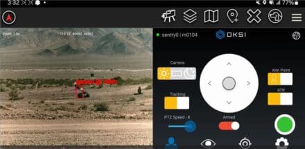
OKSI’s DIS for Remote Weapon Stations (RWS) provides passive and continuous ranging for humans, vehicles and object detection. ATAK application integrates within a closed-loop and basic functionalities including scanning, detect/track, and queuing with both visible and LWIR with zero emission of detectable energy.

Capabilities
– Automatic Detection & Recognition of Drones, Human and Vehicles
– Tracking
– Passive Rangefinding
– Geolocation Reporting & Plotting within ATAK/NET Warrior
– Assisted Aiming with Aimpoint Selection
– Human Activity Estimation and Pose Estimation

Future Enhancements Coming Soon
– Weapons Detections
– Edge/Anomaly Detection
– Threat Prioritization
– Super Resolution Image Enhancement

oksi.ai

SOF Week 25 – GoTAK Trackers

Wednesday, May 14th, 2025

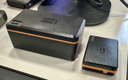
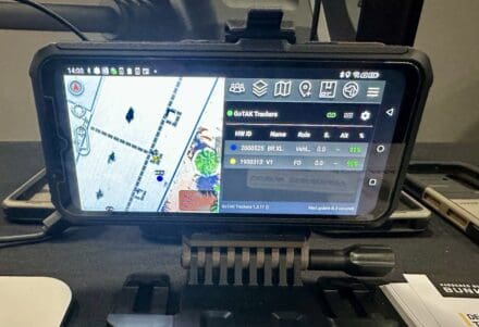
GoTAK exhibited their GoTAK Trackers. Offered in three variants, these low-cost tracking devices are designed to operate globally and integrate directly with Tactical Awareness Kit servers. They feature low power requirements and a compact form factor.

Personnel Tracker

Track your personnel with a key-fob sized device with a 24 hour battery life with 3 second interval updates. Charge easily with the included USB C dock.

Vehicle Tracker

Track your vehicles with the GoTAK Tracker ODB2 that powers and connects to vehicles over the diagnostic port (ODB2). Simply plug it in and the vehicle charges the internal battery for constant operation even with the vehicle is stationary or parked.

Asset Tracker

Track your assets or personnel with the GoTAK Tracker V1 or the XL with the optional magnetic base that fits in the palm of your hand with up to 7 years on a single charge with daily interval updates. Charge easily with the included USB C dock.

getgotak.com

Cubic Digital Intelligence Expands TAKTICS Platform With New Intelligence Feeds for Enhanced Situational Awareness

Wednesday, May 14th, 2025

Delivering powerful radio frequency (RF) intelligence directly to the tactical edge

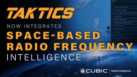
SAN DIEGO, May 12, 2025 -Cubic Digital Intelligence (CDI), a leader in geospatial and full-motion video software solutions, has announced the integration of advanced RF data and analytics from HawkEye 360 into its TAKTICS platform. These capabilities provide mission-critical insights directly to Tactical Assault Kit (TAK) users, strengthening decision-making at the tactical edge.

“This integration reflects our commitment to delivering powerful, real-time intelligence tools that support the operational needs of modern defense missions,” said Paul Sartorius, VP and General Manager at CDI. “By adding these advanced RF analytics to TAKTICS, we’re giving users the ability to act faster, with greater precision and context.”

TAKTICS is a trusted, web-based hub that rapidly delivers geospatial intelligence (GEOINT) data to users operating in time-sensitive and bandwidth-constrained environments. With the addition of HawkEye 360’s advanced RF data and analytics, TAKTICS now offers enriched intelligence derived from space-based RF signal detections, streamlining access to high-value insights through a single, integrated platform.

Enhanced Domain Awareness

HawkEye 360’s RF geolocation data enhances situational understanding across land and maritime environments by continuously detecting and analyzing emissions from signals of interest. This data supports daily updates to the TAKTICS platform and enables users to identify strategic threats without needing access to classified sources. By providing only the most relevant detections, it supports tip-and-cue workflows that allow analysts to efficiently direct additional sensors, such as EO or SAR, for further investigation. The result is persistent, unclassified insight that reduces analyst workload and strengthens mission planning in high-risk and contested areas.

A Unified Tactical Picture

Through these integrations, TAKTICS continues to evolve as a comprehensive intelligence dissemination platform, enabling secure access to critical GEOINT and RF-derived intelligence across desktop and mobile environments.

With TAKTICS, CDI reinforces its mission to get the right data to the right place at the right time – empowering tactical edge users with superior situational awareness, mission planning, and execution capabilities.

SOF Week 25 – EdgeTak by EDT

Tuesday, May 13th, 2025

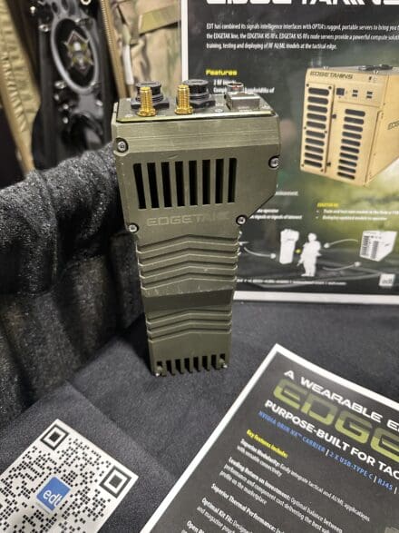
Integrating WIFI / Bluetooth and GPS as well as 2 X USB-TYPE C ports and a RJ45 jack, this TAK server is meant for deployment at the edge. It relies on an NVIDIA ORIN NX Carrier with 8TB of storage.

Key features include:

Superior Modularity: Easily integrate tactical and Al/ML applications with versatile connectivity

Optimal Kit Fit: Designed to fit flexibly on-body including existing radio and magazine pouches

Open Platform: No proprietary software or licenses; the platform is open for customizing the application stack, giving operator full control and mission flexibility

This sounds promising. They are introducing EDGETAK RF this summer which will incorporate a fully integrated spectrum awareness and collection capability from 30MHz- 8GHz.

– 2 x RX/TX channels of up to 80MHz IBW

edt.com

MDM 25 – IXI Electronic Warfare

Thursday, May 1st, 2025

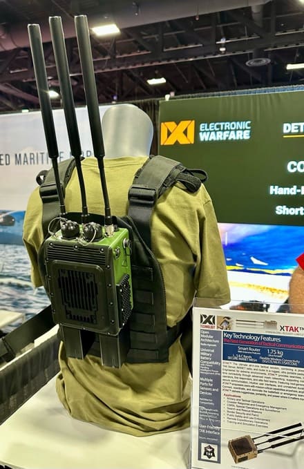
IXI Electronic Warfare exhibited their X-TAC Tactical Awareness Kit server.

The requirement was for a manportable TAK server and IXI EW delivered. Weighing 4.85 lbs with a single hot-swappable PRC-148 / 152 battery (3.85 lbs dry), the XTAK is 6.6″ x 5″ x 3.54″.

Powered by an Intel 17 / Jetson AGX Orin edge computing module, the system communicates in L, S and C Bands – 3X3 MIMO 6-10W, 2.4 GHz, 5 GHz, and 6 GHz and 5G Global Band (Dual SiM). Additionally, there are ports for Ethernet (1 WAN, 2 LAN), USB 3.0 (2), RS232 (1), and NETTWARRIOR.

From a power standpoint, they’ll accept everything from dirty shore power to MBITR batteries, to STUB, to BB-2590. In fact, with a BB-2590 you can expect up to 18 hours.

Cubic Digital Intelligence Unveils Industry-Leading Vector Tile Delivery for TAK Users

Wednesday, March 26th, 2025

Fast, interactive and data-rich mapping for real-time mission intelligence

SAN DIEGO, March 24, 2025 – Cubic Digital Intelligence (CDI), a leader in geospatial intelligence (GEOINT) and advanced full-motion video (FMV) solutions, announces the launch of its vector tile delivery system for the Tactical Assault Kit (TAK) ecosystem.

CDI’s new platform, delivered through the TAKTICS dissemination system, streamlines access to vector tiles from multiple vendors, while providing direct access to mission-critical data. The capability ensures rapid, seamless and scalable geospatial data dissemination for TAK users worldwide, allowing them to quickly locate, retrieve and download the information they need with unparalleled speed and efficiency.

“Our capability represents a major leap forward in delivering next-generation geospatial intelligence to TAK users,” said Paul Sartorius, VP & General Manager at Cubic Digital Intelligence. “We deliver fast, accurate and interactive data visualization, from sensor-to-shooter, enabling warfighters and intelligence professionals to make decisions anywhere, anytime.”

Key Benefits:

Seamless TAK Integration – Built for interoperability, the platform delivers instant access to vector tiles without time-intensive conversions or raster-based overlays.

Optimized for Performance – Unlike traditional hybrid tile approaches, the client-side rendered vectors reduce processing loads while delivering high-fidelity, interactive maps in both 2D and 3D TAK clients.

Scalable and Future-Proof – Supporting multi-vendor data sources, the platform ensures users always have access to the most up-to-date and relevant geospatial information, with no need for reprocessing or additional hardware investments.

Advancing Mission-Critical Geospatial Solutions

Vector tile solutions further enhance our commitment to delivering superior GEOINT dissemination tools that empower defense and intelligence operators with real-time, high-performance geospatial data. By eliminating the inefficiencies of burnt-in rasterization, CDI ensures TAK users can access, interact with and manipulate geospatial intelligence with unprecedented flexibility and clarity.

To learn more: Cubic Digital Intelligence.