Phantom Lights

Archive for the ‘UAS’ Category

GA-ASI Advances Sub-Hunting With Test of New Air-Dropped Sensors

Wednesday, February 26th, 2025

SAN DIEGO – 25 February 2025 – General Atomics Aeronautical Systems, Inc. (GA-ASI) continues to expand the role of unmanned aerial systems, demonstrating the first-ever Anti-Submarine Warfare (ASW) capability on an MQ-9B SeaGuardian®. In a groundbreaking test from January 20-30, 2025, a company-operated MQ-9B SeaGuardian successfully deployed and tested anti-submarine sensors using multiple pre-production Sonobuoy Dispensing System (SDS) pods.

Having already proven its ability to track submerged targets, SeaGuardian took this capability further with GA-ASI’s newly designed SDS pods. These pods deployed multiple sonobuoys to conduct onboard thermal-depth and acoustic data processing. Using Directional Frequency Analysis and Recording (DIFAR), Directional Command Activated Sonobuoy System (DICASS), and Bathythermograph sonobuoys, SeaGuardian effectively detected, tracked, and analyzed underwater targets while collecting critical acoustic intelligence.

“This demonstration represents a major leap forward in unmanned capabilities and marks a major milestone in proving that an unmanned aircraft can perform end-to-end persistent ASW operations,” said GA-ASI President David R. Alexander. “The success of this testing paves the way for enhanced anti-submarine warfare capabilities on the MQ-9B SeaGuardian. We look forward to continued collaboration with the U.S. Navy as they explore innovative solutions for distributed maritime operations in the undersea domain.”

As part of the development process, GA-ASI successfully deployed multiple DIFAR and DICASS test sonobuoys, precisely correlating ejection speed with stress/strain data. This provided a high-fidelity launch model to refine future deployment capabilities.

Naval Air Warfare Center Aircraft Division (NAWCAD) AIRWorks played a key role in supporting and overseeing the development, ensuring the system meets emerging warfighter needs. AIRWorks has partnered with GA-ASI in multiple ASW demonstrations, including the Rim of the Pacific (RIMPAC) exercise in July 2024.

With strong demand already in place from multiple customers, GA-ASI anticipates increasing interest in the MQ-9B SeaGuardian, given its high-end maritime capabilities at a significantly lower cost than traditional manned maritime platforms.

Transforming UAS Operations: UAS Summit at Fort Novosel Paves the Way for Future Innovations

Tuesday, February 25th, 2025

FORT NOVOSEL, Ala. — The U.S. Army Aviation Center of Excellence hosted its Unmanned Aircraft Systems Summit at Fort Novosel, from Feb. 10-13, 2025. The summit brought together subject matter experts and operators from around the world to discuss the future of UAS operations.

The summit, which included representatives from agencies such as Army Futures Command, DARPA, DEVCOM, the Department of Defense and the Army’s various Centers of Excellence, aimed to provide a platform for the sharing of lessons learned and the discussion of strategies to inform requirements moving forward.

Col. Joshua Ruisanchez, director of the U.S. Army Futures Command Aviation Capability Development Integration Directorate, highlighted the importance of air-ground integration as the Army continues to transform. The event provided a venue for discussing strategies and approaches moving forward, informed by current global conflicts and future military engagements. Different agencies working within the UAS space showcased their capabilities, which will inform future requirements.

“We’re learning from all the formations that brief this week on how they’re employing UAS, and we’re capturing those lessons learned,” said Col. Scott Shaw, Maneuver Capabilities, Development and Integration Directorate director from the Maneuver Center of Excellence. “We’re also learning from industry about the capabilities that are out there, and how they can help augment our operations.”

The summit included a range of units, including the 101st Airborne Division, the 82nd Airborne Division and the 75th Ranger Regiment, as well as representatives from Special Forces and other agencies.

“This is a great venue to bring in the air-ground integration as we continue to transform the Army,” said Shaw. “We’re seeing what’s happening in Ukraine and what we think the future of UAS operations will look like.”

The summit also included static displays of UAS systems by over 40 industry partners, as well as flight demonstrations.

“This is super important for the Army as a whole,” said Tyler Booth, the small UAS lead at Fort Novosel. “We’re bringing units from all over the UAS enterprise, and this event is a huge information-gathering and disseminating event. It’s also a chance for industry partners to showcase their UAS systems and demonstrate their capabilities.”

The event marked the first time that commercial UAS systems had been flown in such large numbers at Fort Novosel and required significant coordination and planning to ensure its success.

“It’s a large administrative task, and a lot goes into working with all these companies to ensure that we meet the requirements to be able to do this,” said Booth. “But it’s really great that we can do this here, and it’s a testament to the Army’s commitment to innovation and the development of new technologies.”

The summit was seen as a key step in the Army’s efforts to develop and integrate UAS systems into its operations, and to provide its warfighters with the capabilities they need to succeed on the battlefield.

“Robots, in and of themselves, are moderately interesting,” said Lt. Col. Michael Brabner, the Maneuver Center of Excellence’s Robotics Requirements Division chief. “But the effects they help commanders achieve, that’s the compelling piece of all this. We’re trying to give our warfighters the most lethal, apex-predator, robotic and autonomous systems that they can have to simply and intuitively employ on the battlefield to achieve the desired effects.”

Brabner explained that the Army must innovate during peacetime to avoid being reactive in combat situations. By partnering with industry, the Aviation Center of Excellence, and focusing on the end user — the maneuver warfighter — this summit allows the Army to capitalize on opportunities to innovate, learn, and form requirements. These efforts ensure that the Army can effectively fight and win large-scale combat operations.

The summit was part of a larger effort by the Army to develop and integrate UAS systems into its operations, and to provide its warfighters with the capabilities they need to succeed on the battlefield. As the Army continues to transform and adapt to new technologies and threats, events like the UAS Summit will play a critical role in shaping its future.

By Leslie Herlick, Fort Novosel Public Affairs Office

Rheinmetall at the Xponential Europe Trade Fair: Robotics, Drones and Teleoperated Driving in Focus

Sunday, February 23rd, 2025

From 18 to 20 February 2025, the Xponential Europe trade fair, which focuses on robotics and unmanned systems, will take place for the first time in Düsseldorf. Rheinmetall is the largest exhibitor, underlining its claim to leadership in this field. Under the motto ‘Leadership in unmanned digital ecosystem and robotics’, the Dax-listed technology company and its subsidiaries MIRA GmbH and Yardstick Robotics are presenting their latest developments in the fields of robotics, drones, unmanned systems and teleoperated driving. 

Rheinmetall is showing a wide range of its unmanned systems for military and law enforcement applications, including:

–    the LUNA NG VTOL (Vertical Take-off and Landing), a tactical fixed-wing Unmanned Aerial System with vertical take-off and landing capability, reconnaissance equipment (ISR, Intelligence, Surveillance, Reconnaissance) and optional effectors

–    the Fixed Wing Vehicle FV-002, a fixed-wing drone primarily for close-range reconnaissance

–    the Rotary Wing Vehicle RV-002, a rotary wing drone for close-range reconnaissance with a payload capacity of 750 grams

–    the target drone Fixed Wing Vehicle FV-015

–    the walking robot Robotics L.

MIRA GmbH, a wholly-owned subsidiary of Rheinmetall AG, is paving the way for automated mobility with teleoperation. MIRA uses teleoperation to decouple the driver from the vehicle. This makes it possible to control the vehicle remotely from a control panel located anywhere.

Teleoperation of vehicles on public roads requires powerful IT systems. In the ‘POQUASIA – Post-quantum secure generic IoT application’ project, the Rheinmetall Technology Center, with the support of MIRA GmbH, is developing a scalable, real-time-capable and generic Internet of Things (IoT) platform within a cloud environment.

The aim of the project is to demonstrate the potential of cloud-based applications using the example of teleoperation and to test the use of post-quantum cryptography to protect against future cyber threats. This will provide digital innovations that meet the highest security, latency and availability requirements. The project is funded by the German Federal Ministry for Economic Affairs and Climate Protection and supports the European IPCEI-CIS initiative to realise a unique multi-provider cloud-edge continuum.

During the trade fair, MIRA GmbH and the POQUASIA project are offering visitors to Xponential Europe the opportunity to take a ride in one of their teleoperated shuttle vehicles on public roads. In addition, MIRA GmbH will be providing first-hand information about its innovative technology and its diverse applications in logistics and passenger transport.

Rheinmetall subsidiary YardStick Robotics is a manufacturer of AI-enabled robotic solutions for extreme, unstructured and unpredictable environments. The specialised collaborative cobot ‘YARO Cobot’ is developed for the toughest of missions – in other words, robots for ‘dull, dirty & dangerous’ activities. YardStick Robotics is currently working on solutions for a range of applications from the deep sea to extraterrestrial missions in the future. In keeping with the motto ‘Robots for the World’s Toughest Jobs’, the focus is also on the safe automation of industries that have not previously had access to such robotic solutions.

At Xponential Europe, Yardstick Robotics will be showcasing

·    the outdoor cobot: ‘YARO Cobot’ – a specially developed collaborative robot for reliable use in rough, unstructured outdoor environments

·    an Autonomous Underwater Vehicle (AUV) study – an autonomous underwater platform for precise inspection and monitoring tasks in marine and inland waters

·    MagnetCrawler – an intelligent system for inspecting and monitoring metallic surfaces, e.g. for industrial applications

Xponential Europe is open daily from 9:00 a.m. to 6:00 p.m.from 18 to 20 February 2025. We look forward to welcoming you to our booth 1C25.

For more information about Xponential Europe, visit: www.xponential-europe.de

Quantum Systems Establishes New Leadership to Drive Global Growth and Product Excellence

Friday, February 21st, 2025

Gilching, February 19th, 2025 – Quantum Systems, Europe’s leading innovator in drone technology providing aerial intelligence for both government and commercial clients, announces a new executive leadership structure designed to elevate its growth ambition and technological excellence.

Effective January, company Co-Founder and CEO Florian Seibel transitioned to a Co-CEO role alongside Sven Kruck, who has served as Chief Revenue Officer and Managing Director since joining the company in December 2022. This change underscores Quantum Systems’ strategic focus on aligning visionary product development with robust operational leadership. Florian Seibel will focus on products, technology and strategy, while Sven Kruck will focus on operations, sales and finance.

As part of this transition, Frank Thieser, Chief Financial Officer since 2020, resigns from active management and takes on the role of Senior Advisor to Florian Seibel. Jonas Jarosch, who joined the company in autumn 2024 as Director of Finance, will succeed Frank Thieser as CFO, bringing expertise in financial strategy and operational excellence.

At the same time, Quantum Systems also announces the appointment of Martin Karkour as the new Chief Sales Officer (CSO) at Quantum Systems. He succeeds Sven Kruck, effective February 15th, 2025.

Since founding Quantum Systems a decade ago, Florian Seibel has led its transformation from a startup to a global enterprise with over 400 employees across five countries. Seibel commented:

“I want to dedicate more time to what I do best: Tech, Product & Strategy, and building outstanding teams. That is my real superpower and by the way the foundation of every successful tech startup. You can’t build a company without a product. It’s all about the product. I feel truly fortunate to share the helm with Sven as my Co-CEO.”

Sven Kruck has played a pivotal role in driving the company’s revenue growth and operational efficiency. Reflecting on his journey, Kruck noted:

“I was fortunate to have been at the forefront of Quantum Systems’ revenue and operational growth in my role as Managing Director and CRO. Our focus on manufacturing process improvement and fostering international collaboration has created a dynamic environment driven by innovation and excellence. I am honored to partner with Florian as Co-CEO to shape the future of UAV technology and look forward to dedicating my energy to develop Quantum Systems into a global champion.”

These changes position Quantum Systems to further solidify its position as a global innovator in UAV technology, with a strong commitment to advancing cutting-edge solutions for its clients worldwide.

quantum-systems.com

BlueBird Revolutionizes Tactical VTOL UAVs with Hydrogen Fuel-Cell Technology

Monday, February 17th, 2025

[Emek Hefer, Israel, February 17, 2025] – BlueBird Aero Systems proudly unveils its latest breakthrough: A field-proven operational Vertical Takeoff and Landing (VTOL) UAV, powered by a new PEM Fuel-Cell technology developed over the past several years by H3 Dynamics in the USA. This cutting-edge innovation redefines operational capabilities by delivering an electric VTOL UAV with unprecedented flight endurance of over 6 hours, unmatched reliability and a sustainable energy solution.

The WanderB-VTOL is an electric VTOL Mini-UAS, designed for rapid deployment and operation in any environment. Combat-proven, it can effectively function in GPS-denied and spoofed conditions. The WanderB-VTOL is a mature and proven products, in service with over 25 global customers, with more than 350 platforms delivered to date.

The hydrogen fuel-cell powered WanderB-VTOL has accumulated a considerable number of flight-hours that validated the system’s exceptional performance, including continuous operation for over six hours. BlueBird Aero Systems’ rigorous testing has demonstrated reliability and mission readiness. The fuel-cell enables up to 1000 operational hours (until maintenance round) and requires easy maintenance.

Bluebird Customer’s will be able to enjoy this extended endurance by upgrading their WanderB-VTOL systems with the new Fuel-Cell power source.

The WanderB-VTOL specifications:

Maximum Takeoff Weight (MTOW): 18 kg

Flight Endurance: Over 6 hours

Flight Ceiling: 16,000 feet

Payload Capacity: 1.5 kg

Operational Advantages of Fuel-Cells vs. Lithium Batteries

The fuel-cell provides much higher energy-density than Lithium Batteries, allowing the UAV to stay on target for significantly longer durations at the same weight, with significant operational advantages: reducing takeoffs and landings cycles to reduced strain and maintenance cost, longer and more efficient missions, less “dead” time on the way to the target’s area. For example, a mapping flight powered by a fuel-cell can cover a much larger area.

“This is a significant technological milestone for the tactical UAV industry” said Avi Elraz, VP R&D and Engineering.

A Smarter, Greener Energy Solution

At the core of this revolutionary system lies a hybrid solution, combining a hydrogen fuel- cell with a backup battery. The fuel-cell provides a continuous, clean power source, generating electricity through an electrochemical reaction between hydrogen and oxygen, with water as the only byproduct. The backup battery ensures additional energy when needed and acts as an emergency source of energy.

BlueBird’s solution redefines sustainability in UAV operations, ensuring that environmental responsibility meets high performance. This breakthrough not only offers a significant leap in energy efficiency and mission longevity but also sets a new standard in eco-friendly innovation.

“Bluebird is already leading the VTOL UAV market with battle-proven, reliable and capable UAVs, and now, with WanderB-VTOL powered by Fuel-Cell, even more capable with unmatched endurance for a more effective missions” said Ronen Nadir, Founder and CEO of BlueBird Aero Systems.

With its high performance, high availability and comprehensive customer-support, BlueBird’s fuel-cell powered WanderB-VTOL is tailored to meet the demands of both military and civilian markets.

For more information about the fuel-cell powered WanderB-VTOL and BlueBird’s range of UAS solutions, please visit www.bluebird-uav.com

Soaring to Success: 60th MXG Pioneers Drone Training Program

Thursday, February 13th, 2025

TRAVIS AIR FORCE BASE, Calif. – The 60th Maintenance Group completed the first in-house drone training for Small Unmanned Aerial Systems used for aircraft maintenance in the Department of Defense Jan. 27-31, 2025.

Over the course of five days, the drone training program’s 32 objectives focused on operational competency and flight safety, highlighting the fundamental safety rules for flying on an active airfield. This hands-on course allowed students to apply classroom knowledge in real-world scenarios, gaining valuable experience that directly supports the mission.

“Setting up the program required navigating complex regulations and overcoming significant challenges to qualify Travis Airmen to use drones for remote aircraft inspection,” said U.S. Air Force Chief Master Sergeant Max Dombroski, 60th MXG. “It really is a big step forward.”

Prior to this program, maintainers conducted inspections using a man lift or by walking along aircraft wings with harnesses and fall restraint equipment.

“Being able to use the drone has increased my confidence in my own personal safety,” said Senior Airman Mathew Closas, 860th Aircraft Maintenance Squadron airlift/special mission aircraft maintenance specialist. “This allows me to focus solely on the inspection.”

The drones are equipped with several technological advancements, including multi-spectral cameras, which enhance inspections by detecting hidden discrepancies, tracking structural issues such as cracks and corrosion, and identifying damage beneath the aircraft’s surface.

SrA Amrullo Nazarov, 60th MXG home station coordinator team lead and drone training instructor, said “that this program will improve fleet health, help prevent delays and boost readiness. And hopefully make its way throughout the Air Force and that’s exciting.”

Tech. Sgt. Merci Ovard, 60th MXG home station coordinator flight chief highlighted the significant potential applications of drones for preventative maintenance, emphasizing that using automated predictive model will enable early identification of potential issues.

“We have only just scratched the surface with this technology,” said Ovard.

While the drone itself was approved for airworthiness by Air Mobility Command in October 2024, the course was developed by team members assigned to the 60th MXG and approved by Air Force Special Operations Command in the fourth quarter of 2024.

“In the first week of use alone, drone pilots identified a sheared bolt in a C-17 Globemaster III stabilizer panel, preventing $280,000 in damages,” said Ovard. “The SUAS Aircraft Inspection Program has redefined inspection efficiency and accuracy. This initiative will save Travis AFB over 7,000 man-hours annually, significantly easing the workload on maintenance personnel.”

Story by Gary Edwards, 60th Air Mobility Wing

Drones Reportedly Used in Attack on Mexican General

Saturday, February 8th, 2025

An unspecified number and type of drones have reportedly been used in the attempted assassination of General Jorge Alejandro Gutiérrez Martínez, the newly appointed commander of Mexico’s 42nd Military District.

The attack took place near the town of Dolores, between Guadalupe y Calvo and La Leghuguilla in the state of Chihuahua in northwestern Mexico. Four people were said to be wounded, including Gen. Martínez, two soldiers and a policewoman.

(Gen. Martínez photo via El Financiero)

The following video of the attack has been proliferating across numerous social media platforms and accounts. It appears to show a coordinated attack by multiple drone operators against the small military convoy carrying Gen. Martínez and his security detail. However, it should be noted that other sources attribute this video from a different attack in Tamaulipas.

Regardless of its provenance, the video’s content is pretty clear.

Some of these posts claim the drone(s) used was a Mavic 30T, but at this juncture there is no way to confirm this independently.

Although the results of the attack were lackluster at best (except, of course, from the perspective of the four casualties that took shrapnel), it is attracting a substantial amount of attention. First, due to the rank of the intended victim. Second, and much more sensationally, due to recent reports that narco-traffickers are planning drone attacks on US Border Patrol and other LE and military elements on the border.

For instance, the New York Post recently published excerpts from an “internal memo” which warned, in part,

“On February 1, 2025, the El Paso Sector Intelligence and Operations Center (EPT-IOC) received information advising that Mexican cartel leaders have authorized the deployment of drones equipped with explosives to be used against US Border Patrol agents and US military personal currently working along the border with Mexico…”

Officer safety notifications of this nature (though not this content) are commonly distributed in the LE world to notify LEOs of emerging or imminent credible threats in an AO, a jurisdiction, or against law enforcement in general.

Additional reports of border security personnel exchanging gunfire with Cartel members have ratcheted up tension regarding border issues, though cross-border drone use and attacks against USBP agents are not all new. Mexican transnational criminal organizations have been using drones for years now in a number of ways. And though direct attacks by weaponized drones against either rival organizations or local security forces have not been reported in any great numbers, a comparison to drone use by Ukrainian and Russian forces is inevitable.

And probably righteous. If it hasn’t happened yet, it certainly will, though the wisdom of sustained, direct attacks on US military and law enforcement personnel is dubious from a strictly business Cartel perspective.

Some past examples of Cartel drone use include:

These examples are just a tithe of what could be reported, though to date, we haven’t seen a systemic and coordinated combined arms style attack utilizing drones and Cartel gunmen such as the ones that are now commonplace in Ukraine.

Read more on Border Report. 

See the referenced NY Post article. 


DRW

OMNInav by OKSI: A Breakthrough in GPS-Denied Navigation for Unmanned Aerial Systems

Thursday, February 6th, 2025

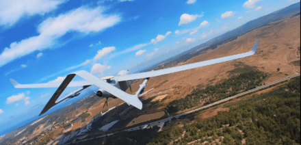
In an era where unmanned aerial systems (UAS) are pivotal in modern conflicts, the ability to navigate effectively in GPS-denied environments has become a critical requirement. Precise navigation is not only important for flying out and returning safely, but for arriving and observing points of interest with onboard sensors. Without drift-free navigation, a platform will end up arriving at the wrong point and observing the wrong area.

At OKSI, we’ve developed OMNInav, a cutting-edge solution that delivers precise and reliable navigation without relying on GPS by combining multiple navigation techniques to maximize performance across a wide range of environments and scenarios. This article highlights the innovative features of OMNInav and its role in addressing the challenges of modern UAS missions. It also highlights its robustness to various environmental and geographical problems sets where most other solutions struggle.

Overview of OMNInav

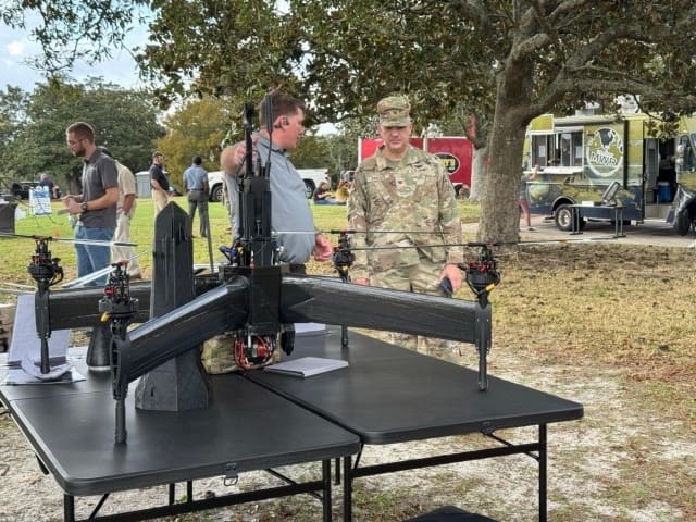
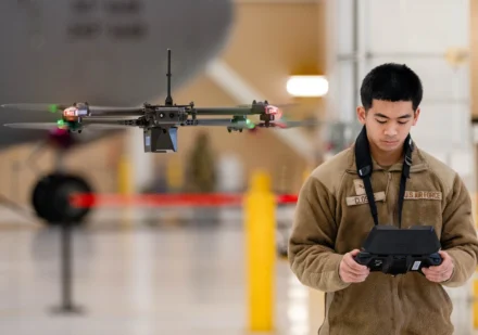
OMNInav is a core component of the Omniscience drone autonomy framework, delivering precise, real-time, multi-modality positional awareness to enable autonomous operations in GPS-denied environments. By integrating seamlessly with popular flight stacks like PX4, ArduPilot, and custom variants, OMNInav replaces GPS input, allowing the autopilot to handle navigation with accurate positional data. It supports a wide range of unmanned airframes, including rotary, fixed-wing, and VTOL aircraft.

Key Features:

  • Modular Design: Seamless integration with existing UAS hardware and software systems.
  • Modular Software Solution: Accelerated containerized software solution ready to deploy on your systems existing companion computer.
  • COTS and Custom Hardware Available: Low SWaP, 70x50x50 mm, weighing 300 grams, and as low as 5 watts of power. Day & Night capable with LWIR camera option.
  • Advanced AI Models: Highly trained AI-based satellite registration models for cross-modality navigation, supporting visible and infrared imagers.
  • Flexible Deployment: Available as a software-only solution or combined hardware and software package.

Understanding GPS-Denied Navigation Methods: Explaining the Weaknesses of Single-Modality Solutions

OMNInav addresses limitations in traditional GPS-denied navigation methods by integrating multiple advanced techniques. Below is a detailed overview of commonly used visual navigation methods and their drawbacks.

1. Optical Flow

  • Definition: Tracks pixel motion in an image stream to estimate relative velocity.
  • Advantages: Computationally efficient and simple to implement.
  • Drawbacks: Does not perform well at higher altitudes and in settings with rapid motion.  Usually requires the use of a laser altimeter to properly scale state estimates.
  • Real-World Example: A drone navigates a smoke-covered battlefield and cannot rely on optical flow alone due to obscured visuals and erratic movement caused by explosions or turbulence.  Sending out laser altimeter energy to get altitude information gives away the drone’s position.


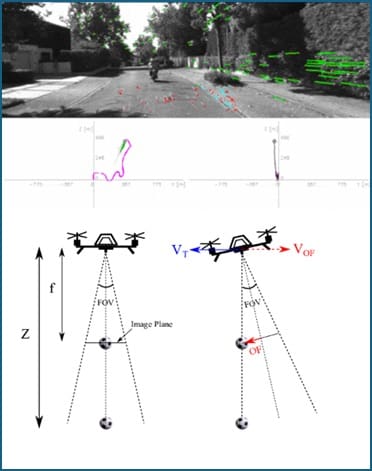
Figure 1: Illustration of optical flow in UAS navigation. (1) a real-world scene from the UAS camera with overlayed optical flow vectors, (2) a plot representing optical flow data, and (3) a diagram showing how the UAS’s field of view (FOV) changes with tilt angles.

2. Visual Inertial Odometry (VIO)

  • Definition: Combines camera and inertial sensor data to estimate motion and position.
  • Advantages: Reduced drift compared to optical flow alone.
  • Drawbacks: VIO can struggle with scale inaccuracies during initialization and is more difficult to implement reliably due to it needing highly synchronized inertial data.
  • Real-World Example: A drone flies to a target using only software synchronized camera and inertial data, leading to low-accuracy scale estimation and missing the target by several hundred meters.


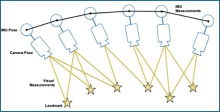
Figure 2: Depiction of Visual-Inertial Odometry (VIO). The image illustrates how a UAS combines data from its camera (camera pose and visual measurements) with inertial measurements from the IMU (inertial measurement unit).

3. Simultaneous Localization and Mapping (SLAM)

  • Definition: Builds a map of the environment while simultaneously localizing the vehicle’s position within the map.
  • Advantages: Provides accurate navigation when flying locally in areas without a prior map.
  • Drawbacks: More computationally demanding in terms of compute and memory to store a live map.
  • Real-World Example: A drone flies several low-altitude orbits over various compounds and can re-localize itself when revisiting a prior orbit.  The additional compute and memory requirements means the drone has a more capable offboard processor in addition to the flight controller.


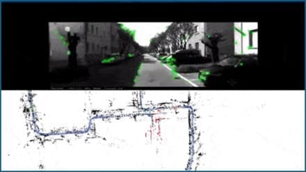
Figure 3: Simultaneous Localization and Mapping (SLAM) in action. The top panel shows a UAS’s camera view with detected visual features highlighted in green, while the bottom panel illustrates a real-time map of the environment generated by the SLAM algorithm. The map includes key structural features and demonstrates loop closure.

4. Feature-Based Localization

  • Definition: Uses pre-stored satellite maps to determine absolute position and correct drift.
  • Advantages: Provides robust, drift-free global positioning.
  • Drawbacks: Requires maps to be loaded to the vehicle.  Provides lower frequency updates and holes in areas where no matches can be found.
  • Real-World Example: A drone transits a long very distance and resets its drift as it flies to arrive at the target with very low error, letting it observe the point of interest autonomously without a pilot fixing the camera.

 
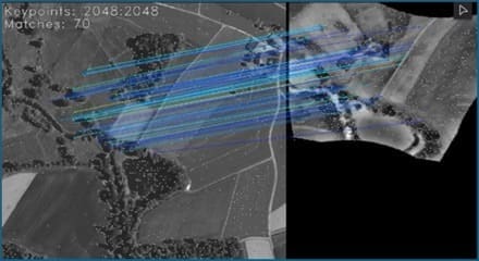
Figure 4: Example of OMNInav’s map-based feature matching for position correction and drift reset. The image illustrates a UAS using feature matching to align its live LWIR camera data (left) with a pre-stored visible map (right).

5. Military-Grade Navigation Systems

  • Definition: Advanced systems used in military applications, often leveraging custom hardware and complex algorithms.
  • Advantages: Highly accurate and reliable in GPS-denied environments.
  • Drawbacks: These systems are prohibitively expensive, bulky, and often proprietary, making them unsuitable for broader commercial applications or cost-sensitive defense missions.
  • Real-World Example: High-end inertial navigation systems (INS) used in military drones provide reliable navigation in GPS-jammed environments but require extensive calibration and are not viable for smaller, lower-budget UAS operations.

OMNInav’s Innovative and Multi-Modality Approach

OMNInav bridges the technology gaps of traditional navigation methods by combining multiple advanced techniques into a unified, multi-modal system. By integrating SLAM for models trained on large-scale satellite imagery datasets for global localization, and robust sensor fusion, OMNInav eliminates the weaknesses of single-method approaches. This innovative design ensures drift-free, accurate navigation across diverse flight profiles, making it ideal for both commercial and defense applications.

Key Features:

  • SLAM for Precise Local Navigation: Creates detailed maps and tracks positions in real-time, providing high frequency positional updates.
  • AI-Based Feature Matching for Global Localization: Provides state-of-the-art, zero-shot global localization by matching observed features to stored datasets and then backing out absolute position to reset drift.
  • Robust Sensor Fusion for Optimal Performance: Calibrates and fuses all available onboard sensors such as airspeed, inertial, and more to provide optimal positional estimates.

Addressing Real-World Challenges

OMNInav’s capabilities excel in overcoming the toughest navigation challenges in GPS-denied environments:

1. Low-Light and Night Operations

Trained on visible and infrared imagery, OMNInav ensures reliable navigation regardless of lighting conditions, camera modality, and map type.


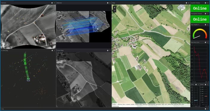
Figure 5. OMNInav’s agnostic modality capability performing with high accuracy in complex repeating pattern farmland.

2. Seasonal and Environmental Changes

Handles vegetation growth, snow cover, and landscape alterations using its robust AI models trained on multi-year satellite imagery.

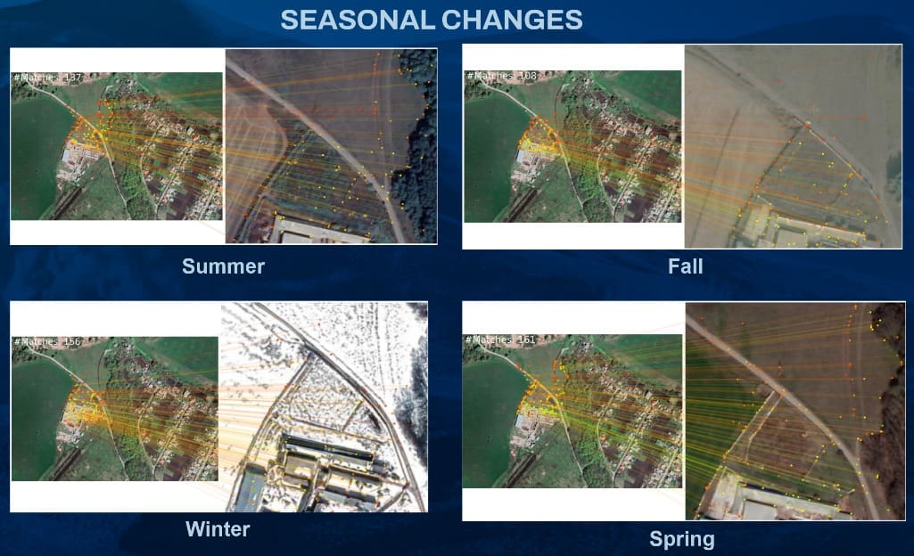
Figure 6. OMNInav is robust, handling seasonal variations from lush greenery to snow-covered terrain.

3. Man-Made Environmental Transformations

Adapts to rapidly changing environments such as construction zones and areas of conflict, ensuring robust navigation accuracy even with very old imagery.  OMNInav has been tested with imagery up to 10 years old successfully even with large-scale map differences.


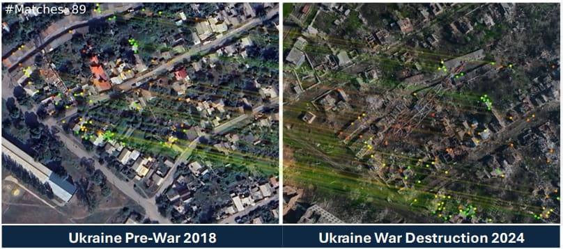
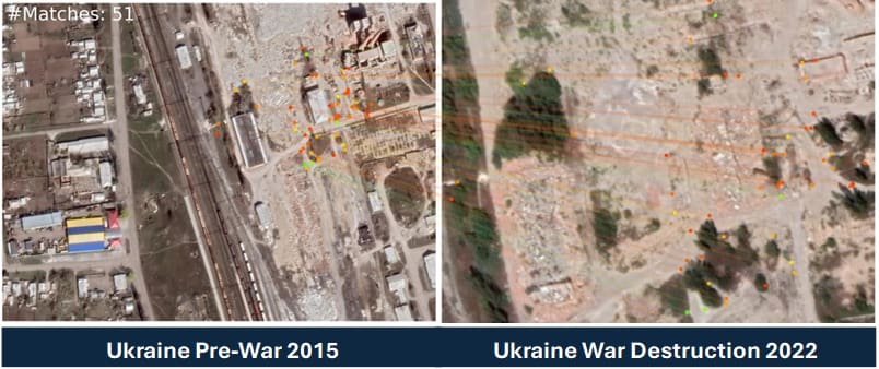
Figure 7. OMNInav accurately registers navigation points despite extensive urban damage.

Competitive Advantage

OMNInav’s unique multi-modal design ensures it outperforms competitors in GPS-denied environments by:

  • Surpassing Single-Method Systems: Combines SLAM and AI-driven feature matching to overcome the limitations of traditional approaches like optical flow, VIO, or basic feature-based localization in isolation.
  • Cost-Effective Alternative to Military-Grade Systems: Offers military-grade reliability without the prohibitive costs, bulks, or calibration demands of high-end inertial navigation systems.
  • Excelling in GPS-Spoofing Scenarios: Fully bypasses GPS reliance, making it indispensable in regions like Ukraine where GPS spoofing and jamming are prevalent.

A Game-Changer in Drone Navigation

OMNInav is redefining the standards for GPS-denied navigation with:

  • Seamless integration into existing systems
  • Superior adaptability to environmental changes
  • Industry-leading accuracy in autonomous operations

To further enhance UAS capabilities, OKSI also offers OMNIlocate, a solution for high-accuracy (CAT I/II) target localization using standard gimbaled sensors. Enabling air platforms to derive high accuracy target position without using GPS.

Ready to take your unmanned systems to the next level?

Discover how the OMNISCIENCE suite can revolutionize your operations with advanced, modular solutions for GPS-denied navigation, tracking, target geolocation, and more. Whether you’re planning complex missions or navigating challenging terrains, OKSI has the tailored tools you need. Explore the full range of OMNISCIENCE modules and cutting-edge technologies from OKSI. Learn more and watch our video series to see how we’re redefining drone autonomy for both defense and commercial applications.

Contact Us

Email: info@oksi.ai
Website: www.oksi.ai/contact 

Learn more: www.oksi.ai/omniscience