Tactical Tailor

Archive for the ‘Tac Apps’ Category

goTenna Releases goTenna Pro X, an Open Platform, Interoperable Tactical Mesh Networking Device

Thursday, March 28th, 2019

goTenna Pro X extends situational awareness capabilities for the professional sector

BROOKLYN, NY (March. 28, 2019) — goTenna, the world’s leading mobile mesh networking company, today released goTenna Pro X, a tactical-grade device that enables scalable mobile mesh networking and total situational awareness for professionals in the field. goTenna Pro X is designed to be used with the world’s leading situational awareness applications as well as open platform ecosystems.

goTenna Pro X used with situational awareness applications supports the efforts of military, law enforcement, wildland firefighters, and disaster response teams, when no service is not an option. goTenna Pro X builds on the functionality of Pro and enables seamless integration with other Android, iOS, Windows, and Linux applications. Current applications include ATAK and AGIS LifeRing with several more in development.

Today’s release builds on the success of goTenna Pro, the company’s tactical-grade mesh networking device that launched in June 2018. Developed by the Department of Defense, the ATAK app is used to support complex communication and coordination needs of more than 100,000 customers worldwide, including the military, Air Force, Army, Special Operations, National Guard, the Departments of Justice and Homeland Security. Developed by AGIS Inc., LifeRing allows users to easily and rapidly establish secure ad hoc digital networks that include all within a selected range.

“goTenna Pro X extends the edge of mission-critical connectivity, enabling operators’ phones to create a resilient peer-to-peer mesh mobile network,” said Daniela Perdomo, goTenna’s co-founder and CEO. “Users can more effectively command and control their missions by remaining connected and contextually aware even in comms-denied environments.”

Smartphones with specialized tactical mapping applications are vital equipment for today’s tactical operators to maintain real-time situational awareness. As seen in the recent spike of climate-related natural disasters, however, responders cannot rely on centralized cellular or wifi connectivity to communicate.

“During the 2018 wildfire season, goTenna Pro X units proved invaluable for communications among our crews and the sharing of vital incident information including personnel location, escape routes and temporary refuge areas,” said Ari Delay, La Honda, CA Fire Chief. “goTenna Pro X was easy to integrate with Tablet Command, the application our crews already use, enhancing operational capability, enabling command and control, and improving responder safety.”

From the Camp Fire in California to Hurricane Michael in Florida, vulnerabilities in central communications infrastructure were exposed. In 2018 alone, traditional communications failed tactical teams due to damage cables and fibers and even data throttling by carriers. Critical failures and loss of service for extended periods of time, compounded with the ever-present threat of cyberattacks, make the front lines where first responders operate particularly susceptible to danger.

To combat this vulnerability, experienced tactical teams including the U.S. military, CALFIRE, and the Texas Department of Public Safety have turned to goTenna for its mesh networking devices and software that enable smartphone connectivity independent of traditional communications infrastructure.

Developed for military and public safety applications, goTenna Pro X is packed with a suite of powerful features:
? Mesh Networking: Users can extend signals through other devices to expand network reach
? 5-Watt RF Transmissions: Power to perform in the most extreme environments
? Tunable: Operate on any frequencies in the 142-175 MHz (VHF) & 445-480 MHz (UHF) ranges
? Advanced Encryption: Up to 384 ECC end-to-end Public Key Infrastructure (PKI) encryption
? Extended Battery Life: Lasts up to 30 hours on a single charge
? ATAK Plug-in: compatible with the leading situational awareness mobile app developed by the DoD.
? goTenna Pro Team Awareness App: includes goTenna’s native app for off-grid situational awareness

How goTenna Pro X Works  
goTenna Pro X combines long-range burst data transmitted over VHF/UHF with iOS and Android devices. Even when unpaired to a smartphone, goTenna Pro X can serve as a multi-hop mesh node for all other Pro X devices – eliminating or reducing the need for base stations and repeaters.

The pocket-sized device pairs to a smartphone via Bluetooth or USB, and all data is displayed in the smartphone application.

Pro X is priced at $849, which includes one mesh-networking radio, the user’s choice of UHF or VHF antenna, the goTenna Pro Team Awareness App, ATAK plug-in (if required) and unlimited service user accounts for field administration and configuration of the Pro X

Pro X Deployment Kits are also available priced at $24,999 per kit. Deployment Kits come standard with 20 Pro X devices, and can charge and maintain up to 30 all in one rugged tactical briefcase. At 25 pounds, Deployment Kits can be easily be transported and deployed anywhere in the world.

Professional users interested in learning more about goTenna Pro X can request more information by visiting gotennapro.com.

About goTenna:

goTenna is the world’s leading mobile mesh networking company and provider of off-grid connectivity solutions for smartphones and other devices. goTenna’s innovative mesh networking protocol is embedded into low-cost, low-power devices and paired with easy-to-use mobile apps enabling mobile, long-range connectivity even without cell, wifi or satellite. The goTenna vision to create resilient connectivity was ignited during Hurricane Sandy in 2012, when approximately a third of cell towers and power stations were knocked out. Based in Brooklyn, goTenna is backed by notable investors including Union Square Ventures, Walden Venture Capital, MentorTech Ventures, BBG Ventures (a subsidiary of Verizon), and Bloomberg Beta. For more information, visit gotenna.com.

About ATAK:

The Department of Homeland Security (DHS) Science and Technology Directorate (S&T) deployed the Android Team Awareness Kit (ATAK) to support the complex communication and coordination needs of the multi-jurisdictional responders. ATAK is one of those game-changers that dramatically alters the user’s understanding of the action in any given area of operation (AO). A government-off-the-shelf app for Android smartphone, ATAK is available to all government agencies for free. The app uses GPS and maps to give the user a real-time view of the AO. This new situational awareness capability includes “Blue Force Tracking” to see where team members are (which reduces friendly fire incidents and helps with coordinating movements), “Red Force Tracking” to see where the bad guys are (obvious advantages), as well as terrain, weather, and other topographical elements. ATAK gives operators in the field a dramatically enhanced real-time situational awareness. It provides them with enterprise information sharing capabilities that will further increase safety, collaboration and mission successes. For more information or to request a copy, visit atakmap.com.

About LifeRing

LifeRing software enables Smartphone, Tablet and PC users to easily and rapidly establish secure ad hoc digital networks that include all within a selected range. Once the AGIS LifeRing Smartphone Icon is selected, LifeRing appears on screen as a map based display. This display provides all on the network with “a sense of where you are”, allowing all users to easily see their present location while enabling them to view the location and status of all other users. Once the visual is in place, LifeRing then provides the means to collaborate, and communicate via PTT, Text Messaging and Voice. The exchange of information occurs in real-time between the participants. For more information, visit agisinc.com/lifering.

Army Researchers Developing Heat Illness Mitigation App

Friday, November 16th, 2018

NATICK, Mass. — There is a delicate balance between training Soldiers rigorously and training them safely.

Warfighters can lose valuable training days due to unit leaders taking overzealous safety precautions, and as a result, they cannot learn and practice the necessary skills to become a ready and lethal force. However, warfighters training rigorously while forgoing safety can lead to disastrous consequences such as heat illness. These consequences can cost the U.S. military valuable training time, money and operational readiness.

Heat illness is a particular concern during warmer months, but that does not mean warfighters have beat the heat as soon as summer has ended. Surprisingly, heat illness can happen year round due to a combination of factors, not just heat and humidity.

“Body heat production from physical activity is the number one factor that causes body core temperature to rise,” said Laurie Blanchard, a biomedical engineer from the U.S. Army Research Institute of Environmental Medicine, or USARIEM. “Hot environments add to body heat gain, and hot and humid environments and heavy clothing make it more difficult to get rid of body heat. Put them all together, and you have a recipe for heat illness.”

To help solve this problem, Blanchard and other USARIEM researchers have been developing a mobile application that can help unit leaders understand how these factors affect military readiness so they can mitigate risk and optimize training.

The Heat Strain Decision Aid, or HSDA, is a tablet- and computer-based app that can help unit leaders and mission planners quickly determine a Soldier’s risk of heat illness during training or operational scenarios. HSDA’s simulations of heat stress, according to Blanchard, support the safe work time tables found in current Army heat injury prevention doctrine, Technical Bulletin Medical 507, or TB Med 507.

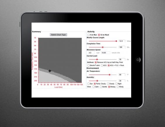
By pressing a few buttons and toggling a few settings, unit leaders can use the science-based guidance on the tablet- and computer-based Heat Strain Decision Aid, or HSDA, to quickly determine a troop’s risk of heat illness during training or operational scenarios. HSDA was developed by U.S. Army Research Institute of Environmental Medicine, or USARIEM, researchers based on over 30 years of studies on heat illness, hydration and core body temperature in simulated and realistic training environments. (Photo Credit: U.S. Army photo by Mallory Roussel )

“HSDA contains equations that predict how body core temperature changes during and after training and how changes in clothing, activity and environment affect the specific rise and fall of body core temperature,” Blanchard said. “This mission planning tool gives unit leaders objective, science-based guidance that can be found in TB Med 507, the Army’s current heat illness and hydration guidance, in a way that is easy and useful for developing prevention and mitigation strategies against heat illness.”

When unit leaders open HSDA on a tablet or computer, they can adjust warfighters’ activities, clothing, the environmental conditions and the intensity and duration of the exercise simply by pressing a few buttons and toggling a few switches. HSDA does the rest of the work by displaying a chart to the user that estimates how likely troops will experience heat illness during a training or operational scenario.

HSDA even shows leaders when warfighters would be most likely to experience a heat illness during the span of an exercise. For example, a unit leader using HSDA could see that Soldiers would be most likely to experience a heat illness during the first hour of a three-hour loaded ruck march.

“One of the advantages of using HSDA is that unit leaders have a tool that helps them visualize how different mitigation strategies can affect their risks of heat illness,” Blanchard said. “Users can manipulate HSDA’s settings to see how changing uniforms, the length and pace of an exercise and the load carried can increase or decrease heat illness risk.

“Even in those cases where the distance, pace and load cannot be altered, such as for a required training event at a specialty school, HSDA can help users plan effective treatment strategies for expected heat casualties, like providing extra ice sheets, closely watching trainees and planning medical evacuations in advance.”

USARIEM researchers developed the user-friendly software interface for the app warfighters know today. Yet the math behind HSDA has existed long before apps were even invented. According to Blanchard, USARIEM developed HSDA from over 30 years of research on heat illness, hydration and body core temperature. Researchers were able to build and validate the equations within HSDA by conducting hundreds of field studies on thousands of subjects in a variety of environments.

Researchers conducted even more laboratory studies at Natick Soldier Systems Center in the Doriot Climatic Chambers, a unique facility that can simulate an extreme range of global weather conditions, from hot deserts to the chilly Arctic. Blanchard and other researchers measured Soldiers’ body core temperatures as they marched on treadmills while carrying external loads and wearing a wide range of clothing, from Army physical training uniforms (shorts and a t-shirt), to Army Combat Uniforms, to insulating chemical, biological and ballistic protective gear.

This year, USARIEM briefed the HSDA app to the Training and Doctrine Command’s Heat Illness and Prevention Subcommittee. USARIEM received several requests for a copy and is now working with the U.S. Army Medical Materiel Development Activity to make HSDA available to download.

Since spring 2018, USARIEM has transitioned a current version of HSDA to the 1st Special Warfare Training Group (Airborne) at the U.S. Army John F. Kennedy Special Warfare Center and School and to the U.S. Air Force 352nd Battlefield Airmen Training Squadron, who both specifically requested to use the app to mitigate heat illness during training. Under an international agreement, USARIEM has also developed a version of HSDA for the U.K. Institute of Naval Medicine, who incorporated the app into their training centers as a tool to reduce the incidence of heat injuries.

“Unit readiness is dependent on rigorous military training,” Blanchard said. “However, training without taking safety precautions, especially during warmer months, can lead to heat illness, heat stroke and even death. These injuries can have significant medical costs, can have long-term medical implications and can force lost training days, impacting unit readiness and individual Soldier careers.

“We have been able to design current versions of HSDA for specific military groups at their sites. Transitioning the app to U.S. and international warfare training groups has allowed us to collect valuable feedback that we can incorporate into HSDA to make it a more robust app that all warfighters can use.”

By Mallory Roussel (USARIEM)

Widget Wednesday: PTX SAT-P Android App

Wednesday, August 29th, 2018

The latest Widget created by the Brainboxes at Protonex is the PTX Situational Awareness Tool for Power (PTX SAT-P). The SAT-P provides an all-in-one solution for managing your PTX SPM-622 Squad Power Manager from your Android phone or tablet.

The app allows users to easily monitor their energy usage in real time and to quickly see key information such as:
• What devices are connected and consuming power?
• What power source is connected and in use?
• How long will the battery last at present rate?

The app also allows users to monitor and update their Power Manager firmware version.

The PTX SAT-P App requires a phone or tablet that will accept an external keypad and is running Android 5.0 or higher, and is available on the Google Play Store at: play.google.com/store/apps/details

For more information about PTX power management systems from Protonex, visit: www.PTXnomad.com

Federal Ammunition Unveils New Enhanced Mobile Ballistics App

Monday, July 9th, 2018

ANOKA, Minnesota – July 9, 2018 – Federal Ammunition’s new enhanced mobile app is a powerful tool to help hunters and shooters streamline and maximize all facets of the shooting experience.

“Technology drives everything at Federal Ammunition,” said Federal Senior Digital Marketing Manager Angie Sullivan. “This all-new app brings a range of advanced tools to one convenient place and allows you to access them even while offline.”

Compatible with Apple and Android smartphones and tablets, the new ballistics app features updated ballistic calculator data and the ability to save ballistics, plus updated ammo recommendations and a fresh, new, user-friendly design.

“With the new Federal Ammunition app, hunters and shooters can quickly and easily determine the trajectory for any rifle or handgun load, and save the data for future reference,” Sullivan continued. “Plus, the app allows you to identify which ammunition to use in a variety of shooting situations, locate your closest Federal dealer and find a nearby shooting range where you can enjoy all the benefits of Federal’s industry leading products.”

The ballistics app also offers detailed information on the components and technology that set Federal Premium products apart from other ammunition.

Consumers can get the app through the iTunes Store or Google Play.

Bushnell Launches New Ballistics Calculator App

Sunday, March 11th, 2018

img_6988.jpgOVERLAND PARK, Kansas – March 9, 2018 – Bushnell, an industry leader in high-performance sport optics, announces the release of a new Bushnell Ballistics App powered by the proven and powerful Applied Ballistics Ultralite Engine.

The new Bushnell Ballistics App is a companion app to use with Bushnell riflescopes to calculate firing solutions for ammunition and rifle combinations. The app allows users to use current atmospheric data and AB Laboratory bullet data to calculate the hold-overs needed to make precise shooting solutions.

“The new Bushnell Ballistics App is powered by the Applied Ballistics Ultralite engine, the most trusted ballistics data-cruncher in the industry,” said Bushnell Marketing Manager Matt Rice. “With a clean and user-friendly interface, this app allows users to easily build and modify gun profiles and build range cards to calculate firing solutions based on their specific scope and ammunition choices. All of our Bushnell scopes and reticles have been pre-loaded, giving users simple ballistic solutions anywhere they go.”

The free app works on both Android and iOS operating systems, and is available on Google Play and the App Store. It is optimized for Bushnell riflescopes and reticles, but is compatible with all optics. Once downloaded, the app functions off the grid, with no cell service required.

The app features AB Connect, which gives users a live library of G1/G7 data as well as the Applied Ballistics Bullet Library with more than 740 pre-loaded bullets. The Bushnell scope library features more than 150 scopes and 30 reticle options. Gun profile management provides up to five saved profiles with reticle-based firing solutions. Plus, multiple target engagement saves up to five targets. Atmospheric data can be updated manually or from the internet when connected. Angle range compensation is also calculated. Range cards can be shared or printed using the Email Range Card Function.

“The new Bushnell Ballistic App puts the power of long-range, first-shot accuracy into the hands of any shooter,” Rice said. “Like all of our products, it was designed to perform in any condition and to offer our consumers true value, with features that far exceed the price—which, in this case, is free!”

To download the app, simply go to Google Play or the App Store and search “Bushnell Ballistics” to get started.

Bushnell, a Vista Outdoor brand, is one of the most recognizable and trusted names in precision hunting, tactical and recreational optics and accessories. For more information, visit www.bushnell.com

NTOA 17 – LeadNav Systems

Tuesday, September 26th, 2017

LeadNav Systems Offers off-the-grid navigation to Off-Road Race teams, Search and Rescue Teams, Military and Law Enforcement, as well as Bikers, Hikers and Off-roaders.

The heart of their system is their app. It allows the user to quickly build and edit routes, import existing tracks, and add audio waypoints. In addition to Map Overlays, the system offers access to mensurated offline Aerial Imagery. Current location, along with that of the other members of the team is via a data linked Iridium satellite phone.

img_1163-2.jpg

In addition to full equipment packages, LeadNav also offers training.

leadnavsystems.com

Kickstarter – BackCountry Navigator XE: Outdoor GPS On iOS & Android

Sunday, September 10th, 2017

BackCountry Navigator XE is a Kickstarter project for mobile outdoor navigation software. The creator, Nathan Mellor, developed the original BackCountry Navigator app, which has been the #1 Maps & Navigation app on the Google Play Store for the past 6 years. In addition to improving the BackCountry Navigator app with the XE version, it will also be available on both iOS and the Web, in addition to Android.

Feature wise, the BackCountry Navigator XE app will feature a wide selection of maps, including topo maps, marine charts, and aerial photography. Overlays will also be provided, such as BLM Boundary maps, property maps, trail maps, and lake map contours, and offline storage of maps will be facilitated with a grid-based organization.

Additional features will include vector topo maps, cloud-based editing, and sharing of routes via links. Plus, as GPS isn’t tied to cellular and data coverage, users can download required maps and use their mobile devices’ on-board GPS to provide location tracking.

www.kickstarter.com/projects/2016384643/backcountry-navigator-xe-outdoor-gps-on-ios-and-an

SPARTANAT – RangePack – iMessage Sticker Pack

Friday, April 21st, 2017

Range Pack

The “RangePack” is an iMessage Sticker Pack for iOS devices made by TACTICALMEASUREMENTS known from their first app MyRPM. It contains useful stickers for the use at the range. This variety of different calibers, targets and sights are allowing you an easy communication with your friends at the range, your gunsmith or local gun dealer. Just DRAG the sticker into your conversation or on a picture, a other sticker or just to show or point something out. The “RangePack” is an iMessage Sticker Pack for iOS devices made by TACTICALMEASUREMENTS known MyRPM.

Range Pack 2

How it works

After downloading the iMessage Sticker Pack called “RangePack” from the App Store it shows up in your iMessenger. After opening the iMessenger presse the Application button to open your iMessage Sticker Packs and select the RangePack. “explain” – Take a picture of your target, mark your shots and show your problem/score to your friend or gunsmith.

Range Pack 3

RANGEPACK on Facebook: www.facebook.com/iOSRANGEPACK
RANGEPACK on Instagram: www.instagram.com/rangepack
RANGEPACK on iTunes: appsto.re/at/WFEeib.i

tacticalmeasurements.com

www.spartanat.com