TYR Tactical

Archive for the ‘Maritime’ Category

SCUBAPRO Sunday – Shackleton

Sunday, February 14th, 2021

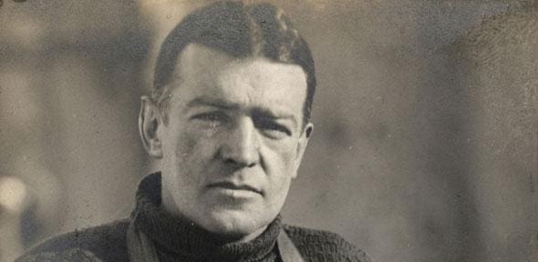
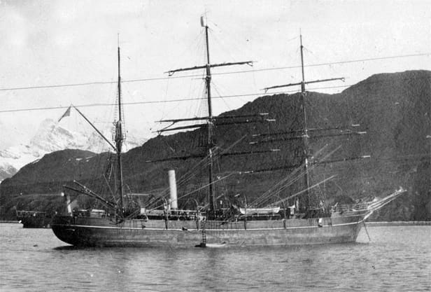
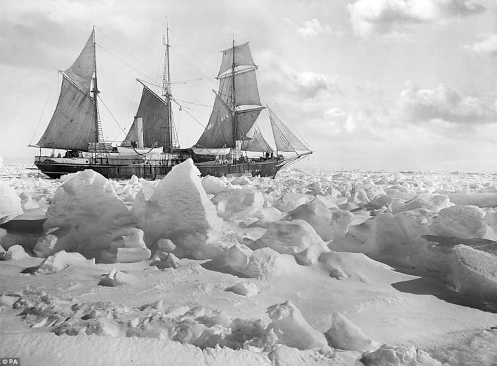
On 5 December 1914, the HMS Endurance left South Georgia for Antarctica, carrying 27 men (plus one stowaway who became the ship’s steward), 69 puppies, and a tomcat named, Mrs. Chippy. The goal of expedition leader Shackleton, who had once agonizingly fallen short of reaching the South Pole twice, was to establish a base on Antarctica’s Weddell Sea coast.

From there, on the first crossing of the continent, a small party, including himself, would eventually arrive at the Ross Sea, south of New Zealand, where another group would be waiting for them, having set up food and fuel depots along the way. Endurance joined the pack ice two days after leaving South Georgia, the barrier of dense sea ice standing guard across the Antarctic continent. The ship pushed its way through leads in the ice for several weeks, gingerly working its way south, but on 18 January, a northern gale jammed the pack hard against the ground and tightly squeezed the floes against each other. There was suddenly no way forward, nor any way back.

They were sailing from their landing place within a day; now, with each passing day, the ice’s drift was slowly moving them farther south. Nothing else could’ve been done but to create a routine and wait for the winter.

The crew saved as many provisions as they could in the time that passed between abandoning Resilience and watching the ice swallow it up entirely while sacrificing anything and anything that added weight or consumed valuable resources, including bibles, books, clothes, instruments, and keepsakes.

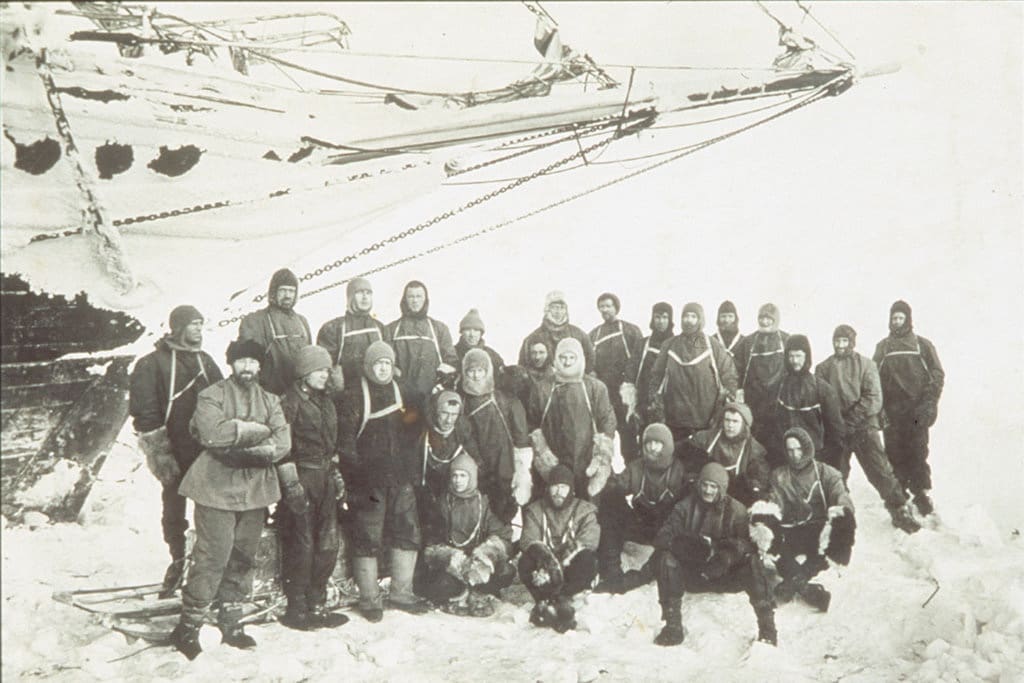
The original plan was to march toward the land through the ice, but that was abandoned after the men accomplished just seven and a half miles in seven days. There was no alternative,” Shackleton wrote, “except to camp on the floe again and to possess our souls with what patience we could until conditions would become more favorable for a revival of the attempt to escape.” The ice drifted further north slowly and steadily, and the snow-capped peaks of Clarence and Elephant Islands came into view on 7 April 1916, flooding them with hope.”

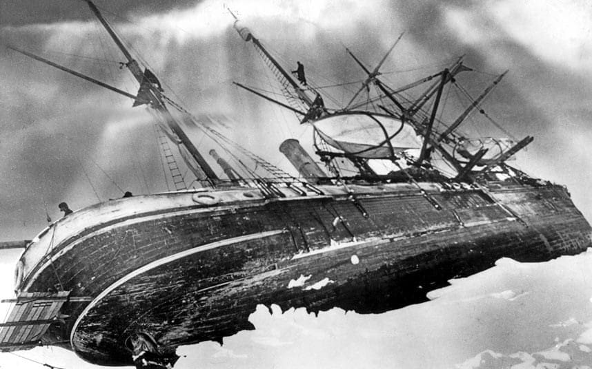
“The floe was a good friend to us,” Shackleton wrote in his diary, “but it has reached the end of its journey and is now obliged to break up at any moment.”

It did precisely that on 9 April, breaking with an almighty crack underneath them. Shackleton gave the order to break camp and launch the ships, and all of a sudden, they were finally free of the ice that had alternately surrounded them and supported them.

Now they had to deal with a new foe: the open ocean. It poured icy spray on their faces and threw cold water over them, beating the boats from side to side, and as they fought the elements and seasickness, it took brave men to the fetal position.

Captain Worsley navigated through the spray and the squalls through all of it before Clarence and Elephant Islands emerged just 30 miles ahead after six days at sea. The men had become tired. Worsley had not slept for 80 hours by that time. And although some have been crippled by seasickness, some have been wracked by dysentery. Frank Wild, the second-in-command of Shackleton, wrote that “at least half the party was insane.” But they rowed resolutely toward their target, and they clambered ashore on Elephant Island on 15 April.

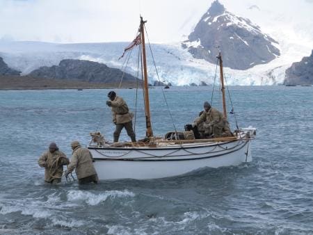
They were on dry land for the first time since leaving South Georgia 497 days ago. Their ordeal was far from over, however. After nine days of healing and training, Shackleton, Worsley, and four others set out on one of the lifeboats, the James Caird, to seek aid from a whaling station in South Georgia, more than 800 miles away. The chance of someone coming across them was vanishingly slight.

They fought monstrous swells and furious winds for 16 days, blowing water out of the ships and beating ice out of the sails. Shackleton recorded, “The boat tossed endlessly at the great waves under grey, threatening skies.” Each surge of the sea was an adversary to be watched and circumvented.” The elements hurled their worst at them even as they were within touching distance of their goal: “The wind  screamed as it ripped the tops off the waves,” Shackleton wrote.” “Our little boat swung down into valleys, up to tossing heights, straining till her seams opened.”

The wind eased off the next day, and they made it ashore. Help was nearly at hand, but this was not the end, either. The winds had driven the James Caird off course, and from the whaling station, they had landed on the other side of the island. And so Shackleton, Worsley, and Tom Crean set out to reach it by foot, scrambling over mountains and sliding down glaciers, forging a route that no human being had ever forged before they stumbled into the station at Stromness after 36 hours of desperate hiking.

In no possible circumstances could three strangers possibly arrive at the whaling station from nowhere, definitely not from the mountains’ direction. And yet here they were: their stringy and matted hair and beards, their faces blackened with blubber stove soot, and creased from almost two years of tension and deprivation.

And the old Norwegian whaler remembered the scene when the three men stood in front of Thoralf Sørlle, the station manager:

The boss would say, “Who the hell are you?” ‘And in the middle of the three, the awful bearded man says very quietly:’ My name is Shackleton.’ I turn away and weep.’

Once the other three James Caird members were rescued, attention turned to the rescue of the remaining 22 men on Elephant Island. Yet, despite all that had gone before, this final mission proved to be the most challenging and time-consuming of all in many respects. Although attempting to cross the pack ice, the first ship on which Shackleton set out ran dangerously low on fuel and was forced to turn back to the Falkland Islands. The government of Uruguay provided a vessel that came within 100 miles of Elephant Island before being beaten back by the ice.

Every morning on Elephant Island, Frank Wild, left in charge by Shackleton, issued an appeal for everyone to “lash up and stow up” their belongings. Might the boss come today! “He proclaimed every day. His friends became increasingly bleak and questionable. Macklin reported on 16 August 1916, “Eagerly on the lookout for the relief ship.” “The hope of her coming was quite abandoned by some of the party.” Orde-Lees was one of them. “There is no longer any good in deceiving ourselves,” he wrote.

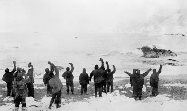
But Shackleton acquired from Chile a third ship, the Yelcho; eventually, on 30 August 1916, the Endurance saga and its crew came to an end. When they spied the Yelcho just off the shore, the men on the island were settling down to a lunch of boiled seal’s backbone. It had been 128 days since James Caird’s departure; everyone ashore had broken camp within an hour of the Yelcho emerging and left Elephant Island behind. Every one of the Endurance crew was alive and healthy twenty months after setting out for the Antarctic.

Never did Ernest Shackleton reach the South Pole or traverse the Antarctic. Another expedition to the Antarctic was initiated, but the Endurance veterans who accompanied him found that he seemed smaller, more timid, drained from the spirit that kept them alive. On 5 January 1922, he had a heart attack on a ship in South Georgia and died in his bunk. He was a mere 47.

Wild took the ship to Antarctica with his death, but it proved inadequate to the task, and he set course for Elephant Island after a month spent futilely trying to penetrate the pack. He and his comrades, from the safety of the deck, peered through binoculars at the beach where so many of them had been living in fear and hope.

“Once again, I see old faces and hear old voices, old friends scattered all over,” Macklin wrote. “It is impossible, however, to express all I feel.”

And with that, one last time, they turned north and went home.

Lifeline Tactical Rescue Tools – JAWZ Titanium

Friday, February 12th, 2021

The JAWZ Titanium from Lifeline is a maritime tool designed for underwater and surface emergencies. The tool features easy one-handed access for low visibility and restricted movement emergency situations. The device effectively cuts rope, monofilament line, netting, webbing, and other materials encountered underwater. The tool is made from Grade 38 ATI 425 Titanium Alloy with handles and sheath made from the latest in phosphorescent technology to dramatically increase underwater visibility with its glow-in-the-dark properties.

shop.lifelinerescuetools.com/lifeline-jawz-ti

Garmin – Descent Mk2i

Wednesday, February 3rd, 2021

The Descent Mk2i is Garmin’s latest watch-style dive computer. It pairs with Garmin’s Descent T1 transmitter via Garmin SubWave, which is a sonar-based communication protocol, to send tank pressure data right to the diver’s wrist.

The Mk2i can accept data from up to five paired Descent T1 transmitters, offering tank pressure, air time remaining, gas consumption rate to monitor other divers or additional tanks within a 10-meter range.

The dive computer function supports multiple dive modes for single and multiple gas dives (including nitrox, trimix and 100% O2), gauge, apnea, apnea hunt and closed circuit rebreather. It also features an underwater 3-axis compass and display depth, dive time, temperature, NDL/TTS, ascent/descent rates, gas mix, PO2, N2 loading, decompression/safety stop information, and time.

You can also share and review up to 200 dives via the Garmin Dive app.

Featuring a 1.4-inch sunlight-readable color display, it’s also a GPS watch for use on the surface. Garmin’s GPS watch features are well known. Anymore, it’s more a matter of what it won’t do rather than talking about what it does. However, we’ll quickly review.

First off is Global Navigation Satellite System connectivity which includes GOS, GLONASS and Galileo. You get position data, turn by turn navigation and round trip routing. There are also Garmin’s classic ABC sensors, including an altimeter for elevation data, barometer to monitor weather and 3-axis compass.

You also get advanced training metrics which include running dynamics, heat- and altitude-adjusted VO2 max, recovery advisor and more. There are also preloaded activity profiles for trail running, swimming, running, biking, hiking, rowing, skiing, and golfing.

Your watch will also guide your workout with animated workouts for cardio, strength, yoga and Pilates. Additionally, PacePro technology helps keep you on pace with grade-adjusted guidance as you run a course.

Respiration, pulse ox and heart rate monitors are all embedded in the Descent Mk2i. And, there are always more apps being added.

What’s more, the Descent Mk2i can be connected to a Garmin inReach satellite communicator at the surface so you can send and receive messages from watch and even trigger an interactive SOS.

Expect about 16 days of battery life from the Descent Mk2i in smartwatch mode and up to 80 hours in dive mode. It has a battery life of up to 32 hours when paired with a Descent T1. The T1 transmitter is depth rated to 11 ATM10 and has a battery life of up to 110 hours of diving with a user-replaceable CR123 battery.

Offered in two versions, Stainless Steel with Black Band and Titanium Carbon Gray DLC with Black Band.

If you’re looking for a Garmin product, I’ve got to recommend Strohman Enterprise, particularly if you’re military or LE.

SCUBAPRO Sunday – Underwater Contour Navigation

Sunday, January 31st, 2021

No matter what you are doing, you should have as many tools stacked in your favor or in your toolbox as you can to help back up your gauges and also make it easier on you. If all else fails, you can use your depth gauge and the depth around the target to find out where you are and where you need to go. It can be as simple as swimming with a reef on one side on the way out and the other on the way back.

Contour lines are used on charts and maps to represent the shape of the land and the ocean’s bottom. By using these lines, you can get a three-dimensional picture of what the bottom should look like.  It is hard to overstate the importance of contours when it comes to navigating. This can also be said about using the background from the water looking towards the land as a form of contour navigation. Knowing things that can help you tell where you are, like the piers’ compass heading, what direction does it go. What will the background look like behind your target, even the silhouette of the buildings? The movement of the moon will be in front or behind the target. If you have to use contour navigation, what would that look like?

You can also use the direction of the waves to find your way back to shore (along shorelines, waves will usually move in the direction of the shore) or using the contours of the bottom to make sure you’re moving in the right direction.

Good navigation begins long before you get into the water. You and your dive buddy should do a target and map/chart study to become very familiar with the target and surrounding area. Valuable information about the site, its features, depths, currents, moon phases, and surrounding features will help build a good dive plan. Discuss constitutes for your profile and which safety precautions you’ll take and agree on a primary route—lastly, walking thru what the dive will be like and what to do if you are lost or come up to different points.

Search for landmarks so you can reset yourself. Distinct underwater features can be found, including coral formations, objects, or differences in the bottom contour. Make sure to note any insights that stand out, and make sure to document every detail. Use what you have learned from the harbor’s contour or where you are diving as you pass through one of the following thresholds: 10 feet, 15 feet, or 20 feet, also. How is the bottom running? Remember to look for landmarks also along your dive route. Follow the light, look for lights, and even the moon if it is out. Check the angle of the moon at the start of your dive or if it hasn’t come up yet, which way will it raise and try to confirm this when you begin your descent. Before you go under, if you are turtle backing, you can use the moon or stars to help you navigate, so you don’t have to look at your navigation board continually. Before I went to BUD’S, I was a boat guy, and I learned to use the stars and moon to help me navigate, many times in the water and on land; this helped because I didn’t always have to be taking my compass out to make sure I was going the right way.

Depending on your dive computer, some like the SCUBAPRO Galileo 2 (G2) allows you to store pictures, so you can store a route card or a picture of the bottom, you can look at what the bottom should be looking like or have a picture of other things around the target to help. The G2 can also be used as a navigation/ attack board. Lastly, don’t be afraid to slow down a little. There is no reason to rush to be further lost than you are. Stop, and come up with a plan and then work that plan.

Inflatable Design – The Mustang Survival RATIS

Monday, January 25th, 2021

Mustang Survival’s RATIS is a Life Preserving Unit (LPU) for SOF operators. Due to its low bulk and weight, it can be attached directly to an armor vest, or worn with its own harness, depending on the application. Additionally, RATIS rights wearers into a face-up position while the system is inflated and offers a buoyancy to weight ratio 40:1.

But the biggest innovation is in the inflator. They use the Hammar COR Electronic Inflator; a single inflator that uses an electronic control unit to enable 4 inflation modes that respond to various depths and/or immersion times. Mustang Survival also introduced a new bladder material which is more pliable, and can be packed smaller, yet when inflated, is still large enough give the buoyancy required. Between the new inflator and bladder material, Mustang Survival changed the PFD game.

Above, you can compare the RATIS on the left to the old, tried and true UDT Vest. Sure, they’re currently used for different applications, but there was a time, not that long ago I might add, that the only solution was the UDT Vest. We’ve come a long way in reducing weight and bulk thanks to Mustang Survival.

Read the entire article at mustangsurvival.com/blogs/blog/inflatable-innovation

SCUBAPRO Sunday – BMCM (MDV) Carl Brashear

Sunday, January 24th, 2021

Master Diver Carl Brashear was born on January 19, 1931, in Tonieville, Kentucky. He joined the Navy in Feb 1948. A 31-year Navy veteran, Brashear retired in 1979 as a Master Chief Boatswain’s Mate, the highest enlisted rank in the U.S. Navy. In 1966 while diving to recover a lost nuclear weapon off Spain’s coast, Brashear was severely injured in an accident. As a result, surgeons amputated his left leg below the knee. He refused to submit to a medical board’s attempt to retire him as unfit for duty. After demonstrating that he could still dive and perform his other duties, he was assigned to Harbor Clearance Unit 2, Naval Air Station Norfolk, Experimental Diving Unit. He was the first person to be returned to full service as a Navy diver after losing a limb in a diving salvage accident. There was a movie made about him in 2000 called Men of Honor. Master Chief Brasher was everything a good senior leader should be; he led from the front, he didn’t take no for an answer when he knew he was right, took care of the people below him, and left the Navy a better place then he found it.

Below, Carl training after he lost his leg, getting back to full active duty status.

usnhistory.navylive.dodlive.mil/2018/01/16/overcoming-hurdles-the-legacy-of-master-chief-carl-brashear

Aqua Lung Names Katie Roberts Director of Military & Professional, North America

Thursday, January 21st, 2021

VISTA, Calif. (January 21, 2021) – Aqua Lung, the celebrated pioneer, designer, manufacturer and distributor of dive and watersports equipment for 75 years, today announced it has appointed Katie Roberts as Director of Military & Professional, North America.

Serving as a key member of Aqua Lung’s North American management group, Roberts will lead the Military & Professional team across the United States and Canada with a focus on driving sales and business development activities for the brand’s channels and customers. Located in the Vista, Calif. office, Roberts reports to Andrew Gritzbaugh, General Manager, North America for Aqua Lung.

“Aqua Lung has a rich history of creating innovative, life-saving products that have sought to push the boundaries of what is possible. I look forward to working with our talented team to meet the needs of Military and Professional customers in North America,” said Roberts.

Most recently, Roberts led government sales and business development in North America for Gerber, the top direct supplier of knives and multitools to the U.S. Military. She is a graduate of the University of Wisconsin-Madison.

“Katie brings a unique skill set to the Aqua Lung team with over a decade of sales and business development experience with the U.S. military, international governments, and institutions,” said Gritzbaugh. “Her specific experience building close relationships with military leadership, navigating complex distribution environments, and organizing internal teams towards shared goals will be great assets in enabling the growth of our business into the future.”

For more information about Aqua Lung, visit www.AquaLung.com.

SCUBAPRO SUNDAY – Dive Gloves

Sunday, January 17th, 2021

Having the right pair of gloves will make your life so much better when working in the water, whether you are doing a two-hour dive in Norway or driving a zodiac for a long-range OTB. The right pair of gloves will depend on what you are doing and how long you are doing it. One of the other factors is the water temperature/ weather. Suppose you need to use your hands a lot during a dive, like pushing a button on a Navigation board, or be able to use your hand right after the dive, like climbing a ladder, shooting a gun. Lastly, how is your tolerance to the cold?  

These will be the main factors to take into account when choosing the thickness of the gloves. The colder the water, the thicker you might need to go.

1-3mm: water between 60- 75 ° F (16-24 ° C)

5-7mm: water between 45-60° F (8-16 ° C)

Here are the two main things you might want to think about when choosing a pair of gloves for military use. 

• Freedom of movement with a minimum amount of thickness that allows you the thermal comfort and protection you will need.

• What is material is on the palm and fingers? Can the gloves be used to grab and hold metal or plastic?

Make sure when you are trying them out to grab different things to make sure they will work. If I am in a store, I will always grab the medal racks to see how they work. They need to be suitable for everything for climbing, shooting, and holding onto different things.

Dive gloves come in a variety of thickness levels between 0.5mm to 7mm. A pair of 1.5mm Tropical gloves that have a leather palm is an excellent place to start. Gloves are like booties because even in warm water, you can have a thicker bootie on, and your feed will not get hot. Always have a warmer glove on without is being that much of a pain. Some tactical gear companies are making gloves designed for being in a wet environment that are also good for diving. The WETWORX gloves from S&S Precision come in two styles. One is thinner for warmer water, and one is a little thinker (2mm) for colder. I know they have put a lot of work into them, and they are nice gloves as more units get back into the water.

That said, S&S makes all their stuff to be used in the water as the owners come from a water background. I like gloves that can hold onto something medal, like if you have to climb a caving ladder or hold onto a gun—also holding plastic like a navigation board or working plastic buckles. Many dive gloves have small plastic beads on them that are not the best for working in the water. It is hard to find a good pair of thick dive gloves that meet the above requirements. If you have to be on a boat or mostly about the water, you can get a pair of dive gloves that are a couple sizes bigger than you usually would wear and put wool gloves on as a base layer. Even when wet, Wool will still hold heat in, and the dive gloves will help keep your hands warm and dry. The same trick works with gloves you will see fisherman use. You can also bring a thinner set of gloves like 1.5mm with you and change them out a couple of minutes before hitting the target. You can try with a thinker pair of gloves to put a set of work gloves on over them. That way, you always have the right grip.

When choosing the right glove, they should fit well enough to avoid water circulation inside as much as possible this will help keep the heat. They should not be so tight because that will cut off circulation to your hands. The thicker the gloves, the more insulated you have, but the tradeoff is this might give you less mobility. So, it will be difficult to manipulate the equipment and also to done and doff them. Choose the gloves that you think will protect you enough for the type of water you will perform most dives. You will want gloves to fit your wrist close to reducing the bulge that can happen if there is too much material between your sleeves and gloves. If you don’t do this right, just moving your hands will let water in, and it will make your hands and you cold.

Dive Gloves Maintenance Tips

Treat dive gloves like you treat anything you want to last. It would help if you cared for gloves like you treat your wetsuit. They should be soaked in freshwater after each dive and not just rinsed. You want to force the salt out. Please do not put them in the washing machine or use detergents to clean your wetsuits or gloves. Allow them to dry in a ventilated place until completely dry. Textile gloves take longer to dry. Do not dry them in the sun, as with all neoprene, it will cause them to age faster.

Images by Paul Wildman (@builtbywildman) ©Paul Wildman