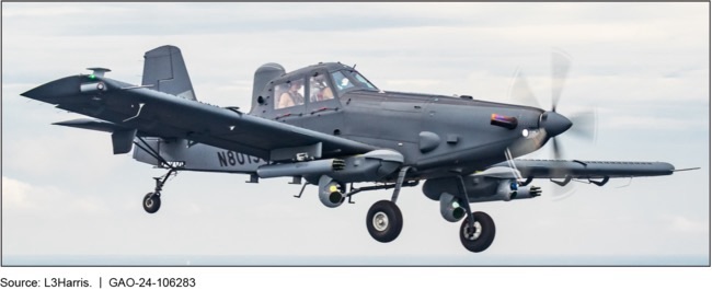
FirstSpear TV

Archive for the ‘ISR’ Category

OverWatch by Aries Defense

Monday, February 14th, 2022

SupplyCore has been out looking for novel C5ISR* technologies and showed me the Overwatch System from a company right in my backyard. Aries Defense is based here in the Tidewater of Virginia and was founded by a small team of coders who specialize in rapid integration of existing systems into distributed networks.

OverWatch began service with the USMC but has rapidly been spread to other services. It is a TLR9 system which is a LOW voltage edge deployable video surveillance platform used to gain close-in situational awareness.  OverWatch will present a “live” view of the battlespace from a fixed and/or concealed position and provides live full motion video over any network.

OverWatch is network agnostic. They have integrated with LTE, SATCOM, Ethernet, and any Tactical radio such as Trellisware, Harris, DTC, Thales, Silvus, Persistent, etc.

OverWatch is also camera agnostic.  It will ingest any digital or analog video stream.  Aries Defense provides Canon/Nikon lens adaptors which allow maximum compatibility with existing lens kits.

Finally OverWatch is integrated into ATAK, WinTAK, and MCH as well as Aries Defense’s own StandAlone App.

Aries Defense products are available for unit and agency purchase through SupplyCore.

*Command, Control, Communications, Computers, Combat Systems, Intelligence, Surveillance, and Reconnaissance

Portable Servers Enhance Army Geospatial Intelligence Training

Saturday, February 12th, 2022

FORT KNOX, Ky. — The Army Geospatial Center has assisted in further modernizing the 412th Theater Engineer Command’s Engineer-Focused Intelligence Training, or ENFIT, geospatial intelligence procedures with two portable high speed imagery servers.

The OPTIA-produced “ammo can” and smaller-sized portable imagery server from TerraMaster provide Engineers with rapid access global map data without reliance on network speeds or bandwidth limitations. The unit connects a laptop to either device and pulls what they need directly from it, cutting down research and product development by as much as 50 percent.

Jorge Morales, Team Lead Geographer with the AGC Warfighter Support Directorate, stated that the AGC integrated both portable systems into the ENFIT program as of the third quarter of 2021, so the AGC anticipated units to send in results of their use shortly.

“The ‘ammo can’ has about 25 terabytes in storage,” he said. “That fits all of the geospatial maps with space to spare for more.”

Morales explained that the maps already on the devices varied depending on what engineers needed, but each were as detailed down to as much as half a meter. He said they provided a “hybrid solution” with both three dimensional and simulation capabilities.

Armed with comprehensive imagery of the entire world, regardless of depth or height, Army Engineers can precisely direct and reinforce U.S. military efforts for assured mission success. Further, at an estimated five pounds each, the servers prove an easy, more than acceptable burden for any unit.

ENFIT is a specialized course where Soldiers use updated geospatial analytic tools with rapid terrain analysis — geospatial data being facts about occurrences, objects and events that are associated with a particular location on Earth’s surface. These give engineer commanders proper foundational, geographical knowledge to make the right decisions as to where operations should take place.

Maj. Gen. Stephen Strand, 412th TEC Commander, emphasized that ENFIT provides new methods to improve top-tier planning for the Army Reserve.

“The ENFIT program significantly enhances the geospatial engineering capabilities of the [412th Theater Engineer Command],” said Strand. “It’s a great program to develop the bench needed to maintain proficiency for years to come.”

Col. Steven Hayden, 412th Theater Engineer Command Chief of Staff, concurred on Strand’s assessment, adding that ENFIT allows Soldiers to use geospatial analytic tools to provide commanders with terrain analysis that shape the battlefield and drive decision.

ENFIT continues in Alexandria, Virginia throughout 2022 with more classes that include these and more modernizing devices.

By MAJ William Allred and SFC Tony Foster, 412th Theater Engineer Command

Counting Elephants – The Hark-1 Radio

Saturday, January 1st, 2022

As Vietnam heated up, the Agency’s need for eyes on the Laotian panhandle increased beyond the support that could be provided by Thai PARU and RTSF advisors. As a result, the CIA was forced to look for other solutions to communicate with its illiterate Lao Theung road watching teams targeting the Ho Chi Minh Trail.

To tackle this problem, the Agency came up with a radio that used pictograms to communicate what a team saw. Crafted from a modified USAF survival unit, the Hark-1 or Hark Box was released early in 1967.

Note the depictions of armor, artillery, AAA, trucks, porters, soldiers, time of day, and direction of travel. The circular button at the center was used to transmit the tally of what was seen moving north and southbound on the trail to an airborne relay station. While the radio doesn’t appear to have a pictogram for elephants, it was given the affection moniker “the Elephant Counter” by Paramilitary Officers involved in the project. To avoid detection, the Hark road watching teams – sometimes numbering up to twenty-four road watchers on a target like the Mu Gia Pass – would be inserted via unmarked “Pony Express” CH-3s very far from their objective.

On the third slide you can see the Hark-1 with antenna deployed in front of Case Officer, Gene Norwinski during a briefing in Savannakhet. The project was wrapped up in 1969 having been overshadowed by a variety of Pentagon projects and new sensors and night vision capabilities like those present on the AC-130.

Written by @Immurement

Edgar Brothers to Deliver Fused Target Locator Solution to British Armed Forces

Wednesday, December 22nd, 2021

After a stringent tender process, Edgar Brothers are proud to announce the award of the multi-year contract by the UK Ministry of Defence to provide and support the British Armed Forces with the Fused Target Locator (FTL) solution for light reconnaissance operations.

The successful system put forward by the Edgar Brothers team includes a carefully selected collaboration of industry leading partners utilising SAFRANs JIM COMPACT Lightweight, multifunctional, long-range binocular system, supported by Forsberg’s MANTIS® Battle Management System, integrated applying EXSEL Groups extensive expertise.

The system integrates to optimise operation of the JIM Compact. This world-leading sensor is remotely controlled on the masthead or tripod from the operator’s MANTIS® software loaded end user device. Providing a lightweight, low signature, multi-sensor surveillance and target acquisition system; that is man portable, vehicle mountable and will detect, recognise and identify likely adversaries at range, which enables timely and effective decision making.

“We are immensely proud to have been selected to supply the FTL system to UK MoD. Along with our industry partners Safran, Forsberg and EXSEL we feel we have created a system that will give our troops the edge in the battlespace for many years to come. The award of this contract enables us to create more jobs “ here in the UK as part of our continued growth strategy.

Mike Newman – Director at Edgar Brothers

For more information, please contact pmd@edgarbrothers.com

TacJobs – USAF Special Reconnaissance

Friday, November 19th, 2021

Special reconnaissance Airmen are special tactics operators with unique training to conduct multi-domain reconnaissance and surveillance across the spectrum of conflict with focus on lethal and non-lethal air-to-ground integration of airpower.

Learn more at www.airforce.com/careers/detail/special-reconnaissance.

AeroVironment’s New Mantis i45 N Multi-Sensor Imaging Payload Delivers Advanced ISR for Nighttime Operations

Wednesday, November 17th, 2021

• Mantis i45 N provides maximum visibility during low-light or nighttime intelligence, surveillance, and reconnaissance (ISR) operations

• All-environment rated payload maintains similar footprint to battle proven Mantis i45, for fast in-field change-out of payloads between day and night operations

• No software updates required to Puma UAS avionics or ground control stations for legacy system compatibility


AeroVironment’s Mantis i45 N provides maximum visibility during low-light or nighttime intelligence, surveillance and reconnaissance (ISR) operations. (Image: AeroVironment, Inc.)

ARLINGTON, Va., Nov. 16, 2021 –AeroVironment, Inc. (NASDAQ: AVAV), a global leader in intelligent, multi-domain robotic systems, today introduced the Mantis™ i45 N, a multi-sensor nighttime imaging payload compatible with Puma™ 2 AE, Puma™ 3 AE and Puma™ LE small unmanned aircraft systems (UAS). Lightweight (905 g) and compact, the new Mantis i45 N joins AeroVironment’s expansive Mantis product line of micro-gimbals delivering high-quality video and imagery downlink to UAS operators.

Mantis i45 N is a dual-axis, gyro-stabilized, multi-sensor nighttime imaging payload designed for maximum visibility during low-light or nighttime intelligence, surveillance and reconnaissance (ISR) operations. The next-generation imaging system features improved long-wave IR (LWIR) thermal cameras with narrow-angle 32 mm and wide-angle 9.2 mm IR with 7.6x electronic zoom, allowing operators to capture high-resolution video at extended range. Designed for both superior night and low-light performance, the new imaging system also includes an upgraded 5-megapixel monochrome low-light camera sensor and high-powered 860 nm laser illuminator. Through its advanced suite of sensors, the Mantis i45 N payload allows Puma UAS operators to extend aircraft standoff distance for covert operations.

“Today’s battlefield is dynamic and UAS operators increasingly rely on multiple payloads to successfully complete their missions,” said Charles Dean, AeroVironment vice president for global business development and sales of UAS. “The new Mantis i45 N is a game changer during low-light or nighttime ISR operations, delivering increased situational awareness and advanced threat detection in any environment.”

Built on the trusted and battlefield proven Mantis i45, the enhanced night variant Mantis i45 N maintains the same housing form-factor, allowing for a quick and simple change-out of payloads between day and night operations. Plug and play operational, no software updates are required for Puma UAS avionics or ground control stations for legacy system compatibility. Mantis i45 N is also natively compatible with AeroVironment’s Crysalis™ next generation ground control solution. To learn more, visit: www.avinc.com/uas/payloads

Marine Corps Establishes the Information Development Institute

Saturday, October 30th, 2021

ARLINGTON, Va. —

The Deputy Commandant for Information established the Information Development Institute, the IDI Portal and available learning and development resources for information technology, cyber and intelligence civilian Marines reflected in MARADMIN 457/21 released on Aug. 31.

Recruiting, developing and training top talent with the right skills needed to fight and win in the information environment is a top priority for DC I.

Since the inception of the program to the beginning of FY22, more than 350 individuals, stationed in the US and aboard, assigned to various units have leveraged resources available to refine their skills and capability in support of the Marine Corps Team.

“As described in the Force Design Annual Update, we need to seek new approaches in training and education that will serve as a force multiplier,” stated Lt. Gen. Matthew Glavy, Deputy Commandant for Information. “Success starts with people. Developing and managing talent is a top priority for the Marine Corps. Information Development Institute is just one way DC I is enabling our civilian workforce to learn the skills needed in support of Force Design.”

The IDI provides a program for continuous development of Marine Corps civilians who deliver information systems, services, and products critical to the Fleet Marine Force. In practice, the IDI provides a centralized one stop shop for training and education opportunities for all Information Civilian Marines at scale.

Within the IDI, information civilian Marines have access to a learning network to include the IDI Pluralsight learning platform, technical training, learning partnerships and learning opportunities.

The newly established learning network is comprised of the IDI Pluralsight learning platform enabling unlimited access to over 10,000 on-demand technology courses and skill-based learning content organized specifically for work roles.

“Information Development Institute is just one way DC I is enabling our civilian workforce to learn the skills needed in support of Force Design.”

Lt. Gen. Matthew Glavy, Deputy Commandant for Information

“The learning platform has provided me with the flexibility to participate in both lecture format training and practical labs without the restrictions of a rigid schedule or location. It is this flexibility, mixed with the short lessons, that let me continue to learn when there are lulls in my daily work,” said Andrew Kosakowski, Information Systems Security Manager assigned to Marine Corps Information Operations Center, DC I. “Overall, I believe this learning platform is a good resource for developing new, refreshing old, and retaining current technical skills I do not use daily.”

Also part of the learning network is Marine Credentialing Opportunities On-Line to supporting credentialing voucher support for IT and cybersecurity civilians.

The IDI learning network is a centralized platform, accessed via the MarineNet eLearning Ecosystem.

Learning experiences and partnerships within the IDI enables industry exchanges and rotational opportunities that encourage cross training. Additionally, the IDI enables collaboration with academic institutions to bring degree-based programs of instruction.

In support of certification and technical training in security, networking, and applications skillsets, IDI has partnered with Naval Information Warfare Center and General Services Administration to provide courses.

“Our IT, cyber and intel civilian Marines are vital to the mission at DC I and enabling the force to operationalize information as a warfighting function,” said Jennifer Edgin, Assistant Deputy Commandant for Information. “We value the diverse skills our civilian force brings to the team and I am proud that we can provide them access to additional training and opportunities to continue to equip them with the skills for the future.”

All IT, Cyber and Intel Civilian Marines who would like to request access to an IDI course or Pluralsight subscription should request via the link: portal.marinenet.usmc.mil/IDI, or email IDI_Team@usmc.mil.

The referenced published MARADMIN: 457/21 can be found at the following link: www.marines.mil/News/Messages/Messages-Display/Article/2759437/announcement-of-the-information-development-institute-idi-learning-resources-fo

By Maj Gregory Carroll, Headquarters Marine Corps

Rampart Range Day 21 – Fischer Connectors

Friday, October 1st, 2021

Fischer Connectors has introduced the Rapid Deploy Camera Pole (RDCP) System featuring quick disconnect camera heads which can be swapped from lowlight EO to IR. The lightweight, extendable carbon fiber pole, facilitates visual inspection and assessment of inaccessible and hard-to-reach areas.

Fischer Connectors products are available for unit and agency orders within Canada from Rampart International.